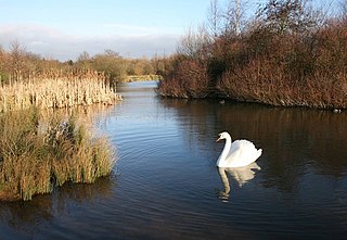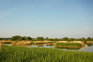
Ouse Washes is a linear 2,513.6-hectare (6,211-acre) biological Site of Special Scientific Interest stretching from near St Ives in Cambridgeshire to Downham Market in Norfolk. It is also a Ramsar internationally important wetland site, a Special Protection Area for birds, a Special Area of Conservation and a Nature Conservation Review site, Grade I. An area of 186 hectares between March and Ely is managed by the Wildlife Trust for Bedfordshire, Cambridgeshire and Northamptonshire and another area near Chatteris is managed by the Royal Society for the Protection of Birds. The Wildfowl & Wetlands Trust manages another area near Welney.

Sandwell Valley RSPB reserve is a nature reserve, run by the RSPB, in Sandwell Valley, to the north of West Bromwich, in the Sandwell borough of West Midlands in England. It is adjacent to, and shares its main lake with, Sandwell Valley Country Park and near the settlement of Hamstead.

The River Tame is a river in the West Midlands of England, and one of the principal tributaries of the River Trent. The Tame is about 95 km (59 mi) long from the source at Oldbury to its confluence with the Trent near Alrewas, but the main river length of the entire catchment, i.e. the Tame and its main tributaries, is about 285 km (177 mi).

The River Rother, a waterway in the northern midlands of England, gives its name to the town of Rotherham and to the Rother Valley parliamentary constituency. It rises in Pilsley in Derbyshire and flows in a generally northwards direction through the centre of Chesterfield, where it feeds the Chesterfield Canal, and on through the Rother Valley Country Park and several districts of Sheffield before joining the River Don at Rotherham in Yorkshire. Historically, it powered mills, mainly corn or flour mills, but most had ceased to operate by the early 20th century, and few of the mill buildings survive.

Warragamba Dam is a heritage-listed dam in the outer South Western Sydney suburb of Warragamba, Wollondilly Shire in New South Wales, Australia. It is a concrete gravity dam, which creates Lake Burragorang, the primary reservoir for water supply for the city of Sydney. The dam wall is located approximately 65 kilometres (40 mi) W of Sydney central business district, 4½ km SW of the town of Wallacia, and 1 km NW of the village of Warragamba.

Sandwell Valley is an area of green belt in the county of West Midlands, England, on the border of Birmingham and West Bromwich, with Walsall at its northern end.

Sandwell Valley Country Park is a country park, run by Sandwell Metropolitan Borough Council, in Sandwell Valley, on the River Tame in the middle of the urban conurbation between Birmingham and West Bromwich in West Midlands, England.

Lake Vyrnwy is a reservoir in Powys, Wales, built in the 1880s for Liverpool Corporation Waterworks to supply Liverpool with fresh water. It flooded the head of the Vyrnwy valley and submerged the village of Llanwddyn.

RSPB Dearne Valley Old Moor is an 89-hectare (220-acre) wetlands nature reserve in the Dearne Valley near Barnsley, South Yorkshire, run by the Royal Society for the Protection of Birds (RSPB). It lies on the junction of the A633 and A6195 roads and is bordered by the Trans Pennine Trail long-distance path. Following the end of coal mining locally, the Dearne Valley had become a derelict post-industrial area, and the removal of soil to cover an adjacent polluted site enabled the creation of the wetlands at Old Moor.

Rainham Marshes is an RSPB nature reserve in the east of London, adjacent to the Thames Estuary in Purfleet, Thurrock and the London Borough of Havering.

Ingrebourne Valley is a local nature reserve (LNR) in Hornchurch in the London Borough of Havering. It is owned and managed by Havering Council, and has a visitor centre managed by the Essex Wildlife Trust. Most of it is in Hornchurch Country Park west of the River Ingrebourne, but there are also areas north and south of the park which are part of the LNR. It has a wide range of habitats, including woodland, grassland, the river and marshes. It is an important site for a range of species of plants, animals and birds, including great crested newts, slow worms, the harvest mouse and the water vole.

Brotherton Park and Dibbinsdale Local Nature Reserve informally known as Dibbinsdale is a combined park and local nature reserve managed by the Metropolitan Borough of Wirral and located in Bromborough, Merseyside, England.

Hamstead railway station serves the Hamstead, Great Barr and Handsworth Wood areas of Birmingham, England. It is located at the junction of Rocky Lane and Old Walsall Road, Hamstead, at Birmingham's border with the borough of Sandwell. It is situated on the Chase Line, part of the former Grand Junction Railway, opened in 1837. The station, and all trains serving it, are operated by West Midlands Trains.

Sheepwash Urban Park is a Local Nature Reserve (LNR), situated in Sandwell Metropolitan Borough, in the West Midlands conurbation of the United Kingdom. It forms part of the Black Country Urban Forest.
Middleton Lakes RSPB reserve is a 160 hectares nature reserve, formally opened on 19 May 2011, created and run by the Royal Society for the Protection of Birds at Middleton, Warwickshire, England, just south of Tamworth. The Northern part of the reserve lies in Staffordshire, yet the reserve is only a few minutes from the outskirts of Birmingham.

Ham Wall is an English wetland National Nature Reserve (NNR) 4 kilometres (2.5 mi) west of Glastonbury on the Somerset Levels. It is managed by the Royal Society for the Protection of Birds (RSPB). Since the last Ice Age, decomposing plants in the marshes of the Brue valley in Somerset have accumulated as deep layers of peat that were commercially exploited on a large scale in the twentieth century. Consumer demand eventually declined, and in 1994 the landowners, Fisons, gave their old workings to what is now Natural England, who passed the management of the 260 hectares Ham Wall section to the RSPB.

Bumble Hole Local Nature Reserve is situated in the Netherton area of Dudley Metropolitan Borough in the county of West Midlands, England. This former industrial area now features canals, ponds, grassland and wooded areas. The reserve lies adjacent to the Warren's Hall Local Nature Reserve. It was declared a local nature reserve in 1996.

Walthamstow Wetlands is a 211-hectare nature reserve in Walthamstow, east London, adjacent to the River Lea in the London Borough of Waltham Forest. It is focused on the Walthamstow Reservoirs, built by the East London Waterworks Company between 1853 and 1904 as part of the Lee Valley Reservoir Chain. The site is one of the largest urban wetland nature reserves in Europe and is particularly important for wildlife due to its position within the Lee Valley. It serves as a byway for migrating, wintering and breeding birds. Visitors can freely access the site's natural, industrial and social heritage in one of the capital's most densely populated urban areas.

Sot's Hole is a local nature reserve in West Midlands, England. It is on the west side of Sandwell Valley, and north-east of West Bromwich.


