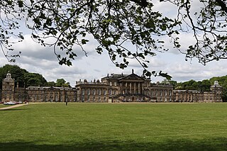
Wentworth Woodhouse is a Grade I listed country house in the village of Wentworth, in the Metropolitan Borough of Rotherham in South Yorkshire, England. It is currently owned by the Wentworth Woodhouse Preservation Trust. The building has more than 300 rooms, with 250,000 square feet (23,000 m2) of floorspace, including 124,600 square feet (11,580 m2) of living area, and was – until it ceased to be privately owned – often listed as the largest private residence in the United Kingdom. It covers an area of more than 2.5 acres (1.0 ha), and is surrounded by a 180-acre (73 ha) park, and an estate of 15,000 acres (6,100 ha).

Richmond is a market town and civil parish in North Yorkshire, England. It is located at the point where Swaledale, the upper valley of the River Swale, opens into the Vale of Mowbray. The town's population at the 2011 census was 8,413. The town is 13 miles (21 km) north-west of Northallerton, the county town, and 41 miles (66 km) north-west of York.

Stamford Bridge is a village and civil parish on the River Derwent in the East Riding of Yorkshire, England, approximately 5 miles (8 km) east of York and 22 miles (35 km) west of Driffield. The village sits astride an ancient ford on the River Derwent.

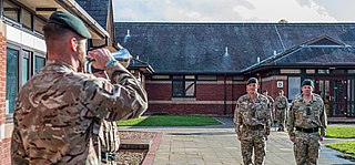
Catterick Garrison is a major garrison and military town 3 miles (5 km) south of Richmond, North Yorkshire, England. It is the largest British Army garrison in the world, with a population of around 13,000 in 2017 and covering over 2,400 acres.

Catterick is a village, civil parish and electoral ward in North Yorkshire, England. Historically part of the North Riding of Yorkshire, it is 8.5 miles (13.7 km) north-west of the county town of Northallerton just to the west of the River Swale. It lends its name to nearby Catterick Garrison and the nearby hamlet of Catterick Bridge, the home of Catterick Racecourse where the village Sunday market is held. It lies on the route of the old Roman road of Dere Street and is the site of the Roman fortification of Cataractonium.

Brompton-on-Swale is a village and civil parish in the Richmondshire district of North Yorkshire, England. The village is located three miles east of Richmond and 10 miles (16 km) north-west of the county town of Northallerton on the northern bank of the River Swale.

Brough with St Giles is a village and a civil parish in North Yorkshire, England. The civil parish also includes the settlements of Catterick Bridge and Walkerville, and Catterick Racecourse and the site of the Roman town of Cataractonium. According to the 2001 Census the parish had a population of 338, increasing to 801 at the 2011 census.

Leeming Bar railway station is a railway station in Leeming Bar, North Yorkshire, England. It is the penultimate eastern rail passenger station of the Wensleydale Railway, though the line continues towards Northallerton. Trains are timed to link in with Dales and District service buses to Northallerton to connect with the National Rail network.

Duncombe Park is the seat of the Duncombe family who previously held the title Earls of Feversham. The title became extinct on the death of the 3rd Earl in 1963, since when the family have continued to hold the title Baron Feversham. The park is situated one mile south-west of Helmsley, North Yorkshire, England and stands in 300 acres (120 ha) of parkland. The estate has a commanding location above deeply incised meanders of the River Rye within the North York Moors National Park.

Hipswell is a village and civil parish in the North Yorkshire (district) of the county of the same name. The civil parish mainly comprises the northern part of Catterick Garrison. The village of Hipswell is at the eastern end of the civil parish, and effectively forms a suburb of Catterick Garrison.

Richmond railway station was a railway station that served the town of Richmond in North Yorkshire, England. The station was the terminus of a branch line that connected with what would become the East Coast Main Line.

Aldershot Garrison, also known as Aldershot Military Town, is a major garrison in South East England, between Aldershot and Farnborough in Hampshire. The garrison was established when the War Department bought a large area of land near the village of Aldershot, with the objective of establishing a permanent training camp for the Army. Over time, this camp grew into a military town and continues to be used by the Army to the present day. It is home to the headquarters of the Army's Regional Command and Home Command, and it is also the headquarters for the Army Special Operations Brigade. The garrison plays host to around 70 military units and organisations.

The A6108 road is an A road in North Yorkshire, England. It runs from the south of Scotch Corner to Ripon going via Richmond and Leyburn across the moors and the valleys of Swaledale and Wensleydale. The road is 37 miles (60 km) long, but through traffic between the two destinations will find a shorter route of 26 miles (42 km) by going south on the A1. The route is single carriageway for its entire length.

The A6136 is a 4 digit A road in North Yorkshire, England. It runs between the A6108 Queen's Road, in the market town of Richmond, before terminating on the A6055 in Catterick, near the A1(M) Junction 52.

Foxholes is a village in North Yorkshire, England, part of the civil parish of Foxholes with Butterwick. It lies where the B1249 road crosses the Great Wold Valley, 9 miles (14.5 km) south from Scarborough, 11 miles (17.7 km) north-west from Bridlington, and 7 miles (11.3 km) north-east from Sledmere. The course of the winterbourne stream the Gypsey Race passes to the south of the village.

St Martin's is a civil parish in North Yorkshire, England. It is located south of the town of Richmond, covering the residential areas south of the River Swale, including the former Richmond railway station and Holly Hill.
Brough with St Giles is a civil parish in the former Richmondshire district of North Yorkshire, England. It contains twelve listed buildings that are recorded in the National Heritage List for England. Of these, one is listed at Grade I, the highest of the three grades, two are at Grade II*, the middle grade, and the others are at Grade II, the lowest grade. The parish contains the village of Brough with St Giles, the hamlet of Catterick Bridge, and the surrounding area. The listed buildings include houses and associated structures, a farmhouse, a hotel, bridges, and a church with associated buildings.

Catterick Bridge is a historic bridge over the River Swale in North Yorkshire, in England.
Catterick is a civil parish in the former Richmondshire district of North Yorkshire, England. It contains 36 listed buildings that are recorded in the National Heritage List for England. Of these, one is listed at Grade I, the highest of the three grades, and the others are at Grade II, the lowest grade. The parish contains the village of Catterick and the surrounding area. To the south of the village is Marne Barracks, formerly RAF Catterick, which contains five listed buildings. Most of the other listed buildings are houses and associated structures, shops and cottages, and the others include a church, a tombstone in the churchyard and its northern gateway, public houses, and a war memorial.
Colburn is a civil parish in the former Richmondshire district of North Yorkshire, England. It contains seven listed buildings that are recorded in the National Heritage List for England. Of these, one is listed at Grade I, the highest of the three grades, one is at Grade II*, the middle grade, and the others are at Grade II, the lowest grade. The parish contains the village of Colburn and the surrounding area, including part of Catterick Garrison to the south of the village. Two of the buildings are in the garrison, and the others are to the north of the village, consisting of a former manor house and an associated courthouse and barn, a cottage, and farm buildings.


