Fort Dale

Last updated

Fort Dale
Greenville, Alabama in United States
The Palings.jpg
"The Palings" stage stop in 1933 as documented during the Historic American Buildings Survey
USA Alabama location map.svg
Red pog.svg
Fort Dale
Usa edcp location map.svg
Red pog.svg
Fort Dale
Coordinates 31°53′33″N86°38′58″W / 31.89250°N 86.64944°W / 31.89250; -86.64944
TypeStockade fort
Site information
OwnerPrivate
Controlled byPrivate
Open to
the public
No
Site history
BuiltMarch 1818
Built byAlabama Territory settlers
In use1818
Events
DesignatedJanuary 29, 1980 [1]

Fort Dale was a stockade fort built in present-day Butler County, Alabama by Alabama Territory settlers. The fort was constructed in response to Creek Indian attacks on settlers in the surrounding area. [2]

Contents

Background

After the Creek War, a number of hostile Creeks (known as Red Sticks) remained in the area surrounding present-day Butler County. The Red Sticks were indignant over the large number of settlers who began traveling down the Federal Road and soon began attacking them. [3] Settlers in the area began building protective stockades such as the one built by Thomas Gary near present-day Greenville. Gary had built a blockhouse and charged residents a fee to stay in it. On March 13, 1818, members of the Ogly and Stroud families were killed by Red Stick warriors under the command of Uchee Tom in what became known as the Ogly-Stroud Massacre. [4] After the massacre, settlers petitioned territorial governor William Wyatt Bibb over the fees Gary was charging. In response, Bibb dispatched Captain Samuel Dale and a number of troops from Fort Claiborne to strengthen Fort Bibb and construct a new fort on the Federal Road. [5]

History

Fort

While under construction, the builders decided to name the fort in honor of Dale. The fort was built on the Federal Road and encompassed a settler's cabin. The fort's defenses consisted of a wooden stockade and two blockhouses. [6] Lieutenant Colonel Gilbert C. Russell described the blockhouses as being built at diagonal angles. [7] Seven days after the Ogly-Stroud Massacre, Captain William Butler, William Gardender, James Saffold, Daniel Shaw, and John Hinson left Fort Bibb towards Fort Dale with a message for Dale. En route, the party was attacked and killed by Reds Sticks under the command of Savannah Jack. This incident became known as the Butler Massacre and added to the settlers' fear. [8] In response, additional troops were sent from Fort Claiborne to reinforce Fort Dale. [4] Soldiers and allied Choctaw warriors were also sent from Fort Crawford to assist in the pursuit of the Red Sticks. [9] Fort Dale was garrisoned from April to June 1818, [7] but some sources indicate it was garrisoned until the end of 1818. [10] Members of the Choctaw tribe served with the 8th U.S. Infantry at Fort Dale during the summer of 1818. [10] Captain W. F. Ware commanded a detachment of cavalry and a Captain Motley commanded infantry at Fort Dale in September 1818. [10] Lieutenant Samuel Riddle of the U.S. Army was also stationed at Fort Dale in the fall of 1818. [10]

An inn and stagecoach stop was built near the site of Fort Dale and was known as "The Palings" (so named due to the palisade of Fort Dale). [5] English merchant Adam Hodgson stayed at "The Palings" on his North American tour, describing it as a "flourishing plantation". [11]

Fort Dale (located in the center) as portrayed in Henry Schenck Tanner's 1830 The Traveler's Pocket Map of Alabama. Fort Dale map.jpg
Fort Dale (located in the center) as portrayed in Henry Schenck Tanner's 1830 The Traveler's Pocket Map of Alabama.

Community

Once the fort was no longer needed for protection, a community grew up around the fort site. The community was originally known as Poplar Spring but later known as Fort Dale. [12] Fort Dale served as the county seat for Butler County from 1819 to 1822. [13] A post office first began operating at Fort Dale in October 1818, with John Herbert serving as the first postmaster. [6] Fort Dale was also a stop on a postal road from Greenville to Hayneville. [14] Fort Dale also had the first school and church in Butler County and served as one of the first voting sites. [5]

Naturalist William Bartram passed by the site of Fort Dale on his four-year journey through the Southern United States. [15]

Present site

Nothing remains of Fort Dale today. The Fort Dale Cemetery lies along Alabama State Route 185 and is near the site of Fort Dale. The cemetery was documented in the 1935 Historic American Buildings Survey and the earliest marked burial in Butler County is located in the cemetery. The cemetery and former fort site are listed on the Alabama Register of Landmarks and Heritage. [16]

Related Research Articles

<span class="mw-page-title-main">Fort Mims massacre</span> Part of the Creek War (1813)

The Fort Mims massacre took place on August 30, 1813, during the Creek War, when a force of Creek Indians belonging to the Red Sticks faction, under the command of head warriors Peter McQueen and William Weatherford, stormed the fort and defeated the militia garrison. Afterward, a massacre ensued and almost all of the remaining mixed Creek, white settlers, and militia at Fort Mims were killed. The fort was a stockade with a blockhouse surrounding the house and outbuildings of the settler Samuel Mims, located about 35 miles directly north of present-day Mobile, Alabama.

Creek Stand is an unincorporated community in Macon County, Alabama, United States.

<span class="mw-page-title-main">Fort Strother</span> United States historic site

Fort Strother was a stockade fort at Ten Islands in the Mississippi Territory, in what is today St. Clair County, Alabama. It was located on a bluff of the Coosa River, near the modern Neely Henry Dam in Ragland, Alabama. The fort was built by General Andrew Jackson and several thousand militiamen in November 1813, during the Creek War and was named for Captain John Strother, Jackson's chief cartographer.

<span class="mw-page-title-main">Fort Crawford (Alabama)</span> United States historic site

Fort Crawford was a fort that once provided defense for settlers in what is today East Brewton, Alabama.

<span class="mw-page-title-main">Canoe Fight (Creek War)</span> Skirmish with Native Indians

The Canoe Fight was a skirmish between Mississippi Territory militiamen led by Captain Samuel Dale and Red Stick warriors that took place on November 12, 1813 as part of the Creek War. The skirmish was fought largely from canoes and was a victory for the militiamen, who only had one member wounded. The victory held little military value in the overall Creek War but its participants gained widespread notoriety for their actions during the fight. The fight has been depicted in multiple illustrations, but only a historical marker currently exists near the site of the fight.

<span class="mw-page-title-main">Fort Claiborne</span> United States historic site in Alabama

Fort Claiborne was a stockade fort built in 1813 in present-day Monroe County, Alabama during the Creek War.

Snowdoun is an unincorporated community in Montgomery County, Alabama, United States. Snowdoun is located on U.S. Highway 331 9.5 miles (15.3 km) south of Montgomery.

Pintlala, also known as Pint Lala or Colquitt, is an unincorporated community in Montgomery County, Alabama, United States, located on U.S. Route 31, 15.6 miles (25.1 km) south of Montgomery.

<span class="mw-page-title-main">Fort Bainbridge</span> United States historic site in Alabama

Fort Bainbridge was an earthen fort located along the Federal Road on what is today the county line between Macon and Russell counties in Alabama. Fort Bainbridge was located twenty-five miles west of Fort Mitchell.

Bermuda is an unincorporated community in Conecuh County, Alabama, United States.

<span class="mw-page-title-main">Fort Armstrong (Alabama)</span> United States historic site

Fort Armstrong was a stockade fort built in present-day Cherokee County, Alabama during the Creek War. The fort was built to protect the surrounding area from attacks by Red Stick warriors but was also used as a staging area and supply depot in preparation for further military action against the Red Sticks.

Fort Bibb was a stockade fort built in present-day Butler County, Alabama during the First Seminole War.

<span class="mw-page-title-main">Chinnabee, Alabama</span> Unincorporated community in Alabama, United States

Chinnabee, also spelled Chinneby or Chinnibee, is an unincorporated community in Talladega County, Alabama, United States.

<span class="mw-page-title-main">Fort Easley</span> United States historic site in Alabama

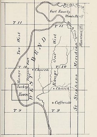
Fort Easley was a stockade fort built in 1813 in present-day Clarke County, Alabama during the Creek War.

<span class="mw-page-title-main">Fort Glass</span> United States historic site in Alabama

Fort Glass was a stockade fort built in July 1813 in present-day Clarke County, Alabama during the Creek War.

<span class="mw-page-title-main">Fort Hull</span> American historical site in Alabama

Fort Hull was an earthen fort built in present-day Macon County, Alabama in 1814 during the Creek War. After the start of hostilities, the United States decided to mount an attack on Creek territory from three directions. The column advancing west from Georgia built Fort Mitchell and then clashed with the Creeks. After a pause in operations, the column from Georgia continued its march and built Fort Hull. The fort was used as a supply point and was soon abandoned after the end of the Creek War.

<span class="mw-page-title-main">Fort Leslie</span> American historical site in Alabama

Fort Leslie was a stockade fort built in present-day Talladega County, Alabama, in 1813 during the Creek War. After the Creek War began, protective stockades were built by settlers and Creeks who were allied with the United States to protect themselves from hostile Creek attacks. Fort Leslie was the focal point of the Battle of Talladega but was soon abandoned after the end of the Creek War.

<span class="mw-page-title-main">Fort Madison (Alabama)</span> United States historic site in Alabama

Fort Madison was a stockade fort built in August 1813 in present-day Clarke County, Alabama, during the Creek War, which was part of the larger War of 1812. The fort was built by the United States military in response to attacks by Creek warriors on encroaching American settlers. The fort shared many similarities to surrounding stockade forts in its construction but possessed a number of differences in its defenses. The fort housed members of the United States Army and settlers from the surrounding area, and it was used as a staging area for raids on Creek forces and supply point on further military expeditions. Fort Madison was subsequently abandoned at the conclusion of the Creek War and only a historical marker exists at the site today.

Fort Montgomery was a stockade fort built in August 1814 in present-day Baldwin County, Alabama, during the Creek War, which was part of the larger War of 1812. The fort was built by the United States military in response to attacks by Creek warriors on encroaching American settlers and in preparation for further military action in the War of 1812. Fort Montgomery continued to be used for military purposes but in less than a decade was abandoned. Nothing exists at the site today.

Fort Pierce, was two separate stockade forts built in 1813 in present-day Baldwin County, Alabama, during the Creek War, which was part of the larger War of 1812. The fort was originally built by settlers in the Mississippi Territory to protect themselves from attacks by Creek warriors. A new fort of the same name was then built by the United States military in preparation for further action in the War of 1812, but the fort was essentially abandoned within a few years. Nothing exists at the site today.

References

  1. "Alabama Register of Landmarks & Heritage Listings as of April 7, 2023" (PDF). ahc.alabama.gov. Retrieved February 4, 2024.
  2. Harris 1977, pp. 40.
  3. Morton, Patricia. "Butler County". Encyclopedia of Alabama. Retrieved February 16, 2021.
  4. 1 2 Little 1885, pp. 25–33.
  5. 1 2 3 "The Federal Road and The Palings/Fort Dale". Historical Marker Database. Retrieved February 17, 2021.
  6. 1 2 Braund, Waselkov & Christopher 2019, pp. 42.
  7. 1 2 Waselkov & Christopher 2012, pp. 150.
  8. "Butler County". Alabama Historical Association. Retrieved February 17, 2021.
  9. Pickett 1878, pp. 621.
  10. 1 2 3 4 Brannon, Peter A. (January 3, 1932). "The Days of Fort Dale". The Montgomery Advertiser. Montgomery, Alabama. Retrieved September 6, 2021.
  11. Braund, Waselkov & Christopher 2019, pp. 71.
  12. "Fort Dale". United States Geological Survey. Retrieved February 16, 2021.
  13. Foscue 1989, pp. 58.
  14. United States Congress 1836, pp. xxxix.
  15. "Alabama". Bartram Trail Conference. Retrieved February 16, 2021.
  16. "Alabama Register of Landmarks and Heritage Nomination Form" (PDF). Alabama Historical Commission. Retrieved February 16, 2021.

Sources