Fort Hunter, New York

Last updated

Fort Hunter is a hamlet in the Town of Florida in Montgomery County, New York, United States, west of the capital at Albany, on the south bank of the Mohawk River and on the northeast bank of Schoharie Creek.

Contents

The hamlet, developed around a fort of the same name, was built by English colonists in 1712 near the Mohawk village of Tionondoroge for their defense. Queen Anne ordered the fort built at the request of the Mohawk, in exchange for their allowing her to settle German Palatines in their territory. The English called the Mohawk settlement the Lower Mohawk Castle. Within a few years, the fort included an Anglican chapel, first built in logs and replaced by a stone church in 1741. It was a mission church for the Mohawk in addition to English settlers. The fort survived the wars in the region; it was taken down in 1820 to make way for construction of the Erie Canal.

History

Land deed

The Fort Hunter land, approximately 80 acres on both sides of the mouth of the Schoharie, was deeded in 1697 to Jan Peterse Mabee. He had an advantage because his wife, Anna Borsboom, apparently of mixed race, was "something related to the Indian castle". [1] The deed was signed by Sachem Rode of the Wolf Clan. In order to build the fort, there was a land swap, with the Mabee family receiving land further south on Schoharie Creek. Copies of the deed are held both in the Albany State Archives and at the shrine of Saint Kateri Tekakwitha in nearby Auriesville, New York.

Palatine settlement

Fort Hunter and Queen Anne's Chapel around 1711 SCFort Hunter.gif
Fort Hunter and Queen Anne's Chapel around 1711

The future site of Fort Hunter was on Schoharie Creek, near the easternmost of the two primary Mohawk settlements of the time. It was in part for defense of the nearby Mohawk village against the French and their Indian allies.

The Mohawk name for their village was rendered variously in English as Tionondoroge, Teantontalago, Thienderego, Tionondorage, and Tiononderoga. The European colonists also called it the Lower Mohawk Castle, referring to its relative position near the Mohawk River, which flows east. Canajoharie , the other primary Mohawk village, was known as the Upper Mohawk Castle and was located further west upriver, also on the south side of the river. By the Dongan Charter, the city of Albany acquired the right to own 1,000 acres (4.0 km2) at the Lower Mohawk Castle.

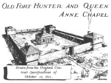
Hendrick Tejonihokarawa of the Wolf Clan, a Mohawk sachem also known by the English as Hendrick Peters, was one of the "Four Mohawk Kings" who went to London in 1710 to meet with Queen Anne. The chiefs asked her for Anglican missionaries to help offset French Catholic influence in the Iroquois Confederacy, as well as for defenses against French soldiers. In 1711, the Crown authorized the construction of Fort Hunter near Tionondorage for such defense. The fort contained a chapel and mission house. Queen Anne donated a set of communion silver and sent two missionaries to the colony.

In return, she asked Tejonihokarawa for help in settling Palatine Germans, Protestant refugees then working at English camps in the Hudson Valley in present-day Dutchess County. They had left the Palatine because of French invasions related to religious wars. Through Governor Hunter, the sachem made some Mohawk land available to settlers near Schoharie Creek, where some of the Palatines eventually settled. [2]

Fort Hunter

Fort Hunter was constructed by English colonists in 1712.

In 1723, some 100 heads of German households were granted land in what was known as the Burnetsfield Patent, west of the rapids at Little Falls. They were a buffer between the French and Iroquois, and the English settlements.

A log cabin was erected for use as a chapel, and at one time there were 30 houses for Mohawk within the fort. The log structure was replaced with a stone church in 1741 and a parsonage was later built outside the fort; it still stands. The fort was used by area residents for defense in the French and Indian War, and during the American Revolution.

Erie Canal

Erie Canal aqueduct at Fort Hunter, NY Erie Canal Aqueduct Schoharie Crossing State Historical Site, Fort Hunter NY 2774 (4029213681).jpg
Erie Canal aqueduct at Fort Hunter, NY

In 1820, the fort and church were taken down to make way for construction of the Erie Canal, which dramatically increased trade and traffic through the valley.

Today

Today, the hamlet of Fort Hunter is the location of the Schoharie Crossing State Historic Site. It includes the remains of the Schoharie Crossing, a navigable aqueduct over the creek, and part of a lock from the early nineteenth-century development of the Erie Canal along the Mohawk River.

Related Research Articles

<span class="mw-page-title-main">Montgomery County, New York</span> County in New York, United States

Montgomery County is a county in the U.S. state of New York. As of the 2020 census, the population was 49,532. The county seat is Fonda. The county was named in honor of Richard Montgomery, an American Revolutionary War general killed in 1775 at the Battle of Quebec. The county is part of the Mohawk Valley region of the state.

<span class="mw-page-title-main">Schoharie County, New York</span> County in New York, United States

Schoharie County is a county in the U.S. state of New York. As of the 2020 census, the population was 29,714, making it the state's fifth-least populous county. The county seat is Schoharie. "Schoharie" comes from a Mohawk word meaning "floating driftwood." Schoharie County is part of the Albany-Schenectady-Troy, NY Metropolitan Statistical Area. The county is part of the Mohawk Valley region of the state.

The Mohicans are an Eastern Algonquian Native American tribe that historically spoke an Algonquian language. As part of the Eastern Algonquian family of tribes, they are related to the neighboring Lenape, whose indigenous territory was to the south as far as the Atlantic coast. The Mohican lived in the upper tidal Hudson River Valley, including the confluence of the Mohawk River and into western New England centered on the upper Housatonic River watershed. After 1680, due to conflicts with the powerful Mohawk to the west during the Beaver Wars, many were driven southeastward across the present-day Massachusetts western border and the Taconic Mountains to Berkshire County around Stockbridge, Massachusetts.

<span class="mw-page-title-main">Danube, New York</span> Town in New York, United States

Danube is a town in Herkimer County, New York, United States. The population was 801 at the 2020 census, down from 1,039 in 2010. Early Palatine German immigrants in the eighteenth century named the town after the Danube River in Europe.

<span class="mw-page-title-main">Florida, Montgomery County, New York</span> Town in New York, United States

Florida is a town south of the Mohawk River in Montgomery County, New York, United States. The population was 2,696 in the 2010 United States Census. The town was named after the state of Florida. It is located in the eastern end of Montgomery County and is south of the City of Amsterdam, which it borders.

<span class="mw-page-title-main">Herkimer (village), New York</span> Village in Herkimer County, New York, US

Herkimer is a village on the north side of the Mohawk River and the county seat of Herkimer County, New York, United States, about 15 miles (24 km) southeast of Utica. As of the 2020 Census, it had a population of 7,234, and a predicted population of 7,283 on July 1, 2022. It was part of the Burnetsfield Patent and the first colonial settlement this far west in the Mohawk Valley.

<span class="mw-page-title-main">Canajoharie (village), New York</span> Village in New York, United States

Canajoharie is a village in the Town of Canajoharie in Montgomery County, New York, United States. As of the 2010 census, the village had a population of 2,229. The name is said to be a Mohawk language term meaning "the pot that washes itself," referring to the "Canajoharie Boiling Pot," a circular gorge in the Canajoharie Creek, just south of the village.

<span class="mw-page-title-main">Canajoharie, New York</span> Town in New York, United States

Canajoharie is a town in Montgomery County, New York, United States. The population was 3,730 in 2010. Canajoharie is located south of the Mohawk River on the southern border of the county. The Erie Canal passes along the northern town line. There is also a village of Canajoharie in the town. Both are east of Utica and west of Amsterdam.

<span class="mw-page-title-main">Schoharie, New York</span> Town in New York, United States

Schoharie is an incorporated town in and the county seat of Schoharie County, New York. The population was 3,107 at the 2020 census.

<span class="mw-page-title-main">Mohawk River</span> River in the U.S. state of New York

The Mohawk River is a 149-mile-long (240 km) river in the U.S. state of New York. It is the largest tributary of the Hudson River. The Mohawk flows into the Hudson in Cohoes, New York, a few miles north of the state capital of Albany. The river is named for the Mohawk Nation of the Iroquois Confederacy. A major waterway, in the early 19th century, the river's east-west valley provided the setting and water for development of the Erie Canal, as a key to developing New York. The largest tributary, the Schoharie Creek, accounts for over one quarter (26.83%) of the Mohawk River's watershed. Another main tributary is the West Canada Creek, which makes up for 16.33% of the Mohawk's watershed.

<span class="mw-page-title-main">Mohawk people</span> Indigenous First Nation of North America

The Kanien'kehá:ka are in the easternmost section of the Haudenosaunee, or Iroquois Confederacy. They are an Iroquoian-speaking Indigenous people of North America, with communities in southeastern Canada and northern New York State, primarily around Lake Ontario and the St. Lawrence River. As one of the five original members of the Iroquois League, the Mohawk are known as the Keepers of the Eastern Door – the traditional guardians of the Iroquois Confederation against invasions from the east. The Mohawk are federally recognized in the United States as the Saint Regis Mohawk Tribe.

<span class="mw-page-title-main">Beaver Wars</span> 17th c. wars between Hurons and Iroquois

The Beaver Wars, also known as the Iroquois Wars or the French and Iroquois Wars were a series of conflicts fought intermittently during the 17th century in North America throughout the Saint Lawrence River valley in Canada and the Great Lakes region which pitted the Iroquois against the Hurons, northern Algonquians and their French allies. As a result of this conflict, the Iroquois destroyed several confederacies and tribes through warfare: the Hurons or Wendat, Erie, Neutral, Wenro, Petun, Susquehannock, Mohican and northern Algonquins whom they defeated and dispersed, some fleeing to neighbouring peoples and others assimilated, routed, or killed.

<span class="mw-page-title-main">Mohawk Valley</span> Six-county region in New York, United States

The Mohawk Valley region of the U.S. state of New York is the area surrounding the Mohawk River, sandwiched between the Adirondack Mountains and Catskill Mountains, northwest of the Capital District. As of the 2010 United States Census, the region's counties have a combined population of 622,133 people. In addition to the Mohawk River valley, the region contains portions of other major watersheds such as the Susquehanna River.

<span class="mw-page-title-main">Schoharie Creek</span> River in New York, United States

Schoharie Creek is a river in New York that flows north 93 miles (150 km) from the foot of Indian Head Mountain in the Catskills through the Schoharie Valley to the Mohawk River. It is twice impounded north of Prattsville to create New York City's Schoharie Reservoir and the Blenheim-Gilboa Power Project.

<span class="mw-page-title-main">Hendrick Theyanoguin</span> Mohawk leader (c. 1691–1755)

Hendrick Theyanoguin, whose name had several spelling variations, was a Mohawk leader and member of the Bear Clan. He resided at Canajoharie or the Upper Mohawk Castle in colonial New York. He was a Speaker for the Mohawk Council. Hendrick formed a close alliance with Sir William Johnson, the Superintendent of Indian affairs in North America.

<span class="mw-page-title-main">Mohawk Upper Castle Historic District</span> Historic church in New York, United States

Mohawk Upper Castle Historic District is a historic district in Herkimer County, New York that was declared a National Historic Landmark in 1993. Located south of the Mohawk River, it includes the Indian Castle Church, built in 1769 by Sir William Johnson, British Superintendent of Indian Affairs, as a missionary church for the Mohawk in the western part of their territory; the Brant Family Barn, a rare surviving example of Dutch colonial barns in the Mohawk Valley; as well as important archaeological site areas revealing life in Nowadaga, as the western part of the Mohawk village of Canajoharie was known. The fortified village was called the Upper Castle by European colonists.

<span class="mw-page-title-main">Schoharie Crossing State Historic Site</span> United States historic place

Schoharie Crossing State Historic Site, also known as Erie Canal National Historic Landmark, is a historic district that includes the ruins of the Erie Canal aqueduct over Schoharie Creek, and a 3.5-mile (5.6 km) long part of the Erie Canal, in the towns of Glen and Florida within Montgomery County, New York. It was the first part of the old canal to be designated a National Historic Landmark, prior to the designation of the entire New York State Barge Canal as an NHL in 2017.

<span class="mw-page-title-main">History of Troy, New York</span>

The history of Troy, New York extends back to the Mohican Indians. Troy is a city on the east bank of the Hudson River about 5 miles (8.0 km) north of Albany in the US State of New York.

<span class="mw-page-title-main">Hendrick Tejonihokarawa</span> Mohawk Sachem (1660–c. 1735)

Hendrick Tejonihokarawa, also known as Tee Yee Neen Ho Ga Row and Hendrick Peters was a pro-English leader of the Mohawk in the Province of New York in the early 18th century. He was one of the "Four Mohawk Kings" who went to London in 1710 to meet with Queen Anne of Great Britain and her court to mark a treaty with her. The chiefs requested the Queen's help in controlling French influence in New York and asked for English missionaries to help their people offset French Catholic influence. The Mohawk diplomacy helped the Iroquois preserve their power through the colonial years.

Tionondogen was the westernmost and most important of the three large palisaded towns of the Mohawk Nation of Iroquois. These towns were termed "castles" by the Europeans. Because of its position as the farthest upstream on the Mohawk River Tionondogen is often referred to as the "Upper Castle".

References

  1. "Genealogies of the Descendants of the First Settlers of Schenectady: McIntosh to Ogden (s.v. "Mebie")". www.schenectadyhistory.org. Retrieved 2020-09-20.
  2. Snow, Dean R. "Searching for Hendrick: Correction of a Historic Conflation" Archived 2008-12-06 at the Wayback Machine . New York History, Summer 2007

Further reading

42°56′32″N74°17′06″W / 42.94222°N 74.28500°W / 42.94222; -74.28500