
Flanders is the Dutch-speaking northern portion of Belgium and one of the communities, regions and language areas of Belgium. However, there are several overlapping definitions, including ones related to culture, language, politics, and history, and sometimes involving neighbouring countries. The demonym associated with Flanders is Fleming, while the corresponding adjective is Flemish, which can also refer to the collective of Dutch dialects spoken in that area, or more generally the Belgian variant of Standard Dutch. The official capital of Flanders is the City of Brussels, although the Brussels-Capital Region that includes it has an independent regional government. The powers of the government of Flanders consist, among others, of economic affairs in the Flemish Region and the community aspects of Flanders life in Brussels, such as Flemish culture and education.

For most of its history, what is now Belgium was either a part of a larger territory, such as the Carolingian Empire, or divided into a number of smaller states, prominent among them being the Duchy of Lower Lorraine, the Duchy of Brabant, the County of Flanders, the Prince-Bishopric of Liège, the County of Namur, the County of Hainaut and the County of Luxembourg. Due to its strategic location as a country of contact between different cultures, Belgium has been called the "crossroads of Europe"; for the many armies fighting on its soil, it has also been called the "battlefield of Europe" or the "cockpit of Europe".

West Flanders is the westernmost province of the Flemish Region, in Belgium. It is the only coastal Belgian province, facing the North Sea to the northwest. It has land borders with the Dutch province of Zeeland to the northeast, the Flemish province of East Flanders to the east, the Walloon province of Hainaut in the south and the French department of Nord to the west. Its capital is Bruges (Brugge). Other important cities are Kortrijk in the south and Ostend (Oostende) on the coast, Roeselare and Ypres (Ieper). The province has an area of 3,197 km2 (1,234 sq mi) which is divided into eight administrative districts (arrondissementen) containing 64 municipalities. As of January 2024, West Flanders has a population of over 1.22 million.

The Yser is a river that rises in French Flanders, enters the Belgian province of West Flanders and flows through the Ganzepoot and into the North Sea at the town of Nieuwpoort.

The 63rd Division was a United Kingdom infantry division of the First World War. It was originally formed as the Royal Naval Division at the outbreak of the war, from Royal Navy and Royal Marine reservists and volunteers, who were not needed for service at sea. For RN personnel, the designation HMS Victory IV was used. The division fought at Antwerp in 1914 and at Gallipoli in 1915. In 1916, following many losses among the original naval volunteers, the division was transferred to the British Army as the 63rd Division, re-using the number from the disbanded second-line 63rd Division Territorial Force. As an Army formation, it fought on the Western Front for the remainder of the war.

The Siege of Antwerp was an engagement between the German and the Belgian, British and French armies around the fortified city of Antwerp during World War I. German troops besieged a garrison of Belgian fortress troops, the Belgian field army and the British Royal Naval Division in the Antwerp area, after the German invasion of Belgium in August 1914. The city, which was ringed by forts known as the National Redoubt, was besieged to the south and east by German forces.
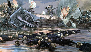
The Battle of the Yser was a battle of the First World War that took place in October 1914 between the towns of Nieuwpoort and Diksmuide, along a 35 km (22 mi) stretch of the Yser River and the Yperlee Canal, in Belgium. The front line was held by a large Belgian force, which halted the German advance in a costly defensive battle.

SMS Hindenburg was a battlecruiser of the German Kaiserliche Marine, the third ship of the Derfflinger class, built to a slightly modified design. She carried the same battery of eight 30.5 cm (12 in) guns, but in improved turrets that allowed them to fire further. The ship was also slightly larger and faster than her two sister ships. She was named in honor of Field Marshal Paul von Hindenburg, the victor of the Battle of Tannenberg and the Battle of the Masurian Lakes, as well as Supreme Commander of the German armies from 1916. The ship was the last capital ship of any type built for the German navy during World War I.

Loppem Castle is a mansion situated in Loppem in the municipality of Zedelgem, near Bruges in West Flanders, in the Flemish Region of Belgium.
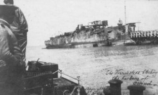
The Second Ostend Raid was the later of two failed attempts made during the spring of 1918 by the United Kingdom's Royal Navy to block the channels leading to the Belgian port of Ostend as a part of its conflict with the German Empire during World War I. Due to the significant strategic advantages conferred by the Belgian ports, the Imperial German Navy had used Ostend as a base for the U-boat campaign during the Battle of the Atlantic since 1915.

The 3rd Cavalry Division was a division of the British Army in the First World War. It was formed at Ludgershall, Wiltshire England in September 1914 under the command of Major-General the Hon. Julian Byng. The division moved to Belgium in the first week of October 1914, landing at Ostend, although its third Brigade was only formed there once. During the war the division took part in most of the major actions where cavalry were used as a mounted mobile force, and also many where the troops were dismounted and effectively served as infantry.
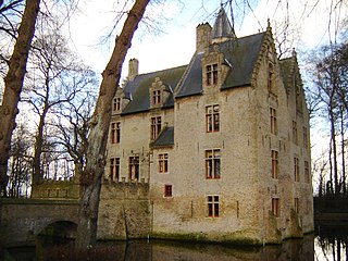
Beauvoorde Castle is a castle in Wulveringem, which since 1977 has been part of the municipality of Veurne, West Flanders, Belgium.

Beschermd erfgoed is the official term to describe Flemish National Heritage Sites listed by law to protect and spread awareness of Belgian cultural heritage, specifically in Flanders. The term is also used nationwide to refer to national heritage sites. Because Belgium is officially a tri-lingual country, the other nationwide terms used in the rest of the country are the French term Bien classé and the German term Kulturdenkmal.

Haasdonk is a village and deelgemeente (sub-municipality) of Beveren in East Flanders, Belgium. Haasdonk was an independent municipality until 1 January 1977, when it merged with Beveren as part of the fusion of municipalities in Belgium. It is located about 12 kilometres (7.5 mi) west of Antwerp.

The history of Belgium in World War I traces Belgium's role between the German invasion in 1914, through the continued military resistance and occupation of the territory by German forces to the armistice in 1918, as well as the role it played in the international war effort through its African colony and small force on the Eastern Front.
Fort Knokke or Fort de Cnocke or Fort de la Knocque or Fort de Knocke was an important fortification that defended western Flanders from the 1580s until it was demolished in the 1780s. During its 200 year history, the place was held by the Spanish Empire, Kingdom of France, Habsburg Austria and the Dutch Republic. The existing defenses were improved in 1678 by the famous military engineer Sébastien Le Prestre de Vauban. The fort was attacked by the Grand Alliance in 1695 during the Nine Years' War but the French garrison successfully held out. It was captured from the French by a ruse in 1712 during the War of the Spanish Succession. Control of the fort and other strong places in the Austrian Netherlands was a key feature of the so-called Barrier Treaty in 1713. The French captured the fort after a two-month siege in 1744 during the War of the Austrian Succession. Emperor Joseph II had the citadel demolished in 1781. The site is on the Yser River about 8 kilometres (5 mi) southwest of Diksmuide, Belgium.
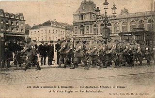
The German occupation of Belgium of World War I was a military occupation of Belgium by the forces of the German Empire between 1914 and 1918. Beginning in August 1914 with the invasion of neutral Belgium, the country was almost completely overrun by German troops before the winter of the same year as the Allied forces withdrew westwards. The Belgian government went into exile, while King Albert I and the Belgian Army continued to fight on a section of the Western Front. Under the German military, Belgium was divided into three separate administrative zones. The majority of the country fell within the General Government, a formal occupation administration ruled by a German general, while the others, closer to the front line, came under more repressive direct military rule.

The Lange Max Museum (LMM) is devoted to the German 38 cm SK L/45 "Max" gun and the German occupation of Koekelare and the nearby area in World War I. The focus on the German side of the war makes it a unique museum in Belgium. The museum is named after the nickname of the German gun "Lange Max", which was one of the biggest guns in the world in 1917, and is located in Koekelare.
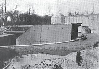
Batterie Pommern, also known as Lange Max, was the world's biggest gun in 1917, during World War I. The German gun was of type 38 cm SK L/45 "Max" and had a modified design by Krupp compared to earlier German 38 cm gun types. The modification allowed the gun to shoot from Koekelare to Dunkirk, which is about 50 km away.

Wulpen is a village in the municipality of Koksijde in the Belgian province of West Flanders. The village can be reached via the N39. Until 1970, Wulpen was an independent municipality.


