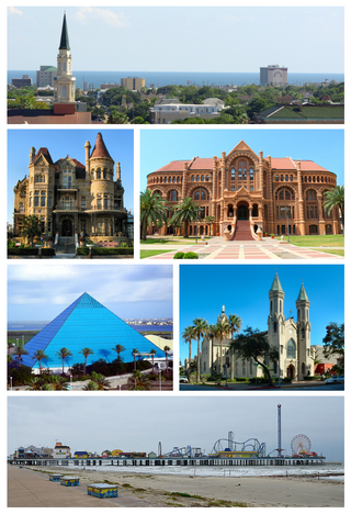
Galveston is a coastal resort city and port off the Southeast Texas coast on Galveston Island and Pelican Island in the U.S. state of Texas. The community of 211.31 square miles (547.3 km2), with a population of 53,695 at the 2020 census, is the county seat of surrounding Galveston County and second-largest municipality in the county. It is also within the Houston–The Woodlands–Sugar Land metropolitan area at its southern end on the northwestern coast of the Gulf of Mexico.

Galveston County is a county in the U.S. state of Texas, located along the Gulf Coast adjacent to Galveston Bay. As of the 2020 census, its population was 350,682. The county was founded in 1838. The county seat is the City of Galveston, founded the following year, and located on Galveston Island. The most-populous municipality in the county is League City, a suburb of Houston at the northern end of the county, which surpassed Galveston in population during the early 2000s.

Bacliff is a census-designated place (CDP) in north-central Galveston County, Texas, United States, 16 miles (26 km) northwest of Galveston. The population was 9,677 at the 2020 census, up from 8,619 at the 2010 census. Bacliff, originally called Clifton-by-the-Sea, began as a seaside resort town. Located on the western shore of Galveston Bay, Bacliff, along with San Leon and Bayview, are the largest unincorporated communities on the Galveston County mainland.

Baytown is a city in the U.S. state of Texas, within Harris and Chambers counties. Located in the Houston–The Woodlands–Sugar Land metropolitan statistical area, it lies on the northern side of the Galveston Bay complex near the outlets of the San Jacinto River and Buffalo Bayou. It is the sixth-largest city within this metropolitan area and seventh largest community. Major highways serving the city include State Highway 99, State Highway 146 and Interstate 10. At the 2020 U.S. census, Baytown had a population of 83,701, and it had an estimated population of 84,324 in 2022.

Texas City is a city in Galveston County, Texas, United States. Located on the southwest shoreline of Galveston Bay, Texas City is a busy deepwater port on Texas's Gulf Coast, as well as a petroleum-refining and petrochemical-manufacturing center. The population was 51,898 at the 2020 census, making it the third-largest city in Galveston County, behind League City and Galveston. It is a part of the Houston metropolitan area. It is notable as the site of a major explosion in 1947 that demolished the port and much of the city.

League City is a city in the U.S. state of Texas, in Galveston County, within the Greater Houston metropolitan area. The population was 114,392 at the 2020 census.

Greater Houston, designated by the United States Office of Management and Budget as Houston–The Woodlands–Sugar Land, is the fifth-most populous metropolitan statistical area in the United States, encompassing nine counties along the Gulf Coast in Southeast Texas. With a population of 7,510,253 in 2023, Greater Houston is the second-most populous metropolitan area in Texas after the Dallas–Fort Worth metroplex.

Clear Lake City is a master-planned community located in southeast Harris County, Texas, within the Bay Area of Greater Houston. It is the second-largest master-planned community in Houston – behind Kingwood. The majority of the community lies in the corporate limits of Houston, and a small eastern portion within the city limits of Taylor Lake Village.

Galveston Bay is a bay in the western Gulf of Mexico along the upper coast of Texas. It is the seventh-largest estuary in the United States, and the largest of seven major estuaries along the Texas Gulf Coast. It is connected to the Gulf of Mexico and is surrounded by sub-tropical marshes and prairies on the mainland. The water in the bay is a complex mixture of sea water and fresh water, which supports a wide variety of marine life. With a maximum depth of about 10 feet (3 m) and an average depth of only 6 feet (2 m), it is unusually shallow for its size.

Galveston Island is a barrier island on the Texas Gulf Coast in the United States, about 50 miles (80.5 km) southeast of Houston. The entire island, with the exception of Jamaica Beach, is within the city limits of the City of Galveston in Galveston County.
Texas A&M University at Galveston (TAMUG) is an ocean-oriented branch campus of Texas A&M University offering both undergraduate and graduate degrees. Students enrolled at Texas A&M University at Galveston, known affectionately as 'Sea Aggies', share the benefits of students attending Texas A&M University (TAMU) campus in College Station. TAMUG is located on Pelican Island, offering benefits for its maritime focused majors.
Fort Crockett is a government reservation on Galveston Island overlooking the Gulf of Mexico originally built as a defense installation to protect the city and harbor of Galveston and to secure the entrance to Galveston Bay, thus protecting the commercial and industrial ports of Galveston and Houston and the extensive oil refineries in the bay area. The facility is now managed by the US NOAA National Marine Fisheries Service, and hosts the Bureau of Commercial Fisheries Laboratory, the Texas Institute of Oceanography, as well as some university facilities. The area still contains several historical buildings and military fortifications.

The Galveston Bay Area, also known as Bay Area Houston or simply the Bay Area, is a region that surrounds the Galveston Bay estuary of Southeast Texas in the United States, within Houston–The Woodlands–Sugar Land metropolitan area. Normally the term refers to the mainland communities around the bay and excludes Galveston as well as most of Houston.

San Luis Pass is a passage of water on the Texas Gulf Coast of the United States. It connects the sheltered waters of West Bay to the open Gulf of Mexico between Galveston Island and San Luis Island.

Hurricane Ike caused major destruction in Texas with crippling and long-lasting effects, including death, widespread damage, and impacts to the price and availability of oil and gas. Hurricane Ike also had a long-term impact on the U.S. economy. Making landfall over Galveston as a Category 2 hurricane, at 2:10 a.m. CDT on September 13, 2008, Hurricane Ike caused extensive damage in Texas, with sustained winds of 110 mph (180 km/h), a 22 ft (6.7 m) storm surge, and widespread coastal flooding.

The Free State of Galveston was a satirical name given to the coastal city of Galveston in the U.S. state of Texas during the early-to-mid-20th century. Today, the term is sometimes used to describe the culture and history of that era.

The history of Galveston, Texas, begins with the archaeological record of Native Americans who used the island. The first European settlements on the island were constructed around 1816. The Port of Galveston was established in 1825 by the Congress of Mexico following its successful revolution from Spain. The city served as the main port for the Texas Navy during the Texas Revolution. Galveston was founded in 1836 by Michel Menard, Samuel May Williams, and Thomas F. McKinney, and briefly served as the capital of the Republic of Texas. The Battle of Galveston was fought in Galveston Bay during the American Civil War when Confederate forces under Major General John B. Magruder attacked and expelled occupying Union troops from the city.
For a period of over 7000 years, humans have inhabited the Galveston Bay Area in what is now the United States. Through their history the communities in the region have been influenced by the once competing sister cities of Houston and Galveston, but still have their own distinct history. Though never truly a single, unified community, the histories of the Bay Area communities have had many common threads.

East Bay also known as East Galveston Bay, is the eastern extension of Galveston Bay found in Chambers County, Texas. The bay is oriented northeast to southwest, and is approximately five miles wide and twenty miles in length. It covers the area north of the entire Bolivar Peninsula, and south of mainland Texas, including the small community of Smith Point at the western extreme. The bay's one extension is Rollover Bay, which is found to the extreme east near the town of Gilchrist.

Christmas Bay is a small bay located on the Texas Gulf Coast in Brazoria County, Texas, immediately southwest of West Bay, near the Galveston Bay system's southwest corner. It is a minor estuary, one of a series of estuaries along the Gulf Coast of Texas, and receives the discharge from Bastrop Bayou, along with the adjacent coastal watershed. The bay is separated from the Gulf of Mexico by Follet's Island and connects with it through San Luis Pass and Cold Pass. Its minor extensions are Bastrop Bay to the north and Drum Bay to the southwest. The nearest city is Freeport, about 10 miles (16 km) to the southwest at the mouth of the Brazos River.
