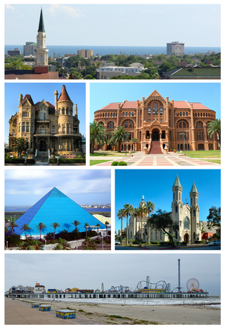
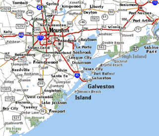
Galveston is a coastal resort city and port off the Southeast Texas coast on Galveston Island and Pelican Island in the U.S. state of Texas. The community of 209.3 square miles (542 km2), with a population of 53,695 in 2020, is the county seat of surrounding Galveston County and second-largest municipality in the county. It is also within the Houston–The Woodlands–Sugar Land metropolitan area at its southern end on the northwestern coast of the Gulf of Mexico.

Galveston County is a county in the U.S. state of Texas, located along the Gulf Coast adjacent to Galveston Bay. As of the 2020 census, its population was 350,682. The county was founded in 1838. The county seat is the City of Galveston, founded the following year, and located on Galveston Island. The most-populous municipality in the county is League City, a suburb of Houston at the northern end of the county, which surpassed Galveston in population during the early 2000s.

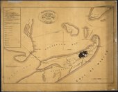
Bolivar Peninsula is a census-designated place (CDP) in Galveston County, Texas, United States. The population was 2,417 at the 2010 census. The communities of Port Bolivar, Crystal Beach, Caplen, Gilchrist, and High Island are located on Bolivar Peninsula.
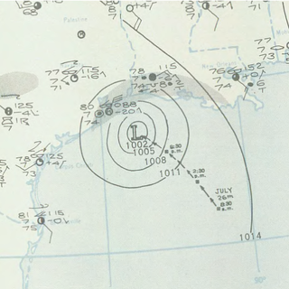
The 1943 Surprise Hurricane was the first hurricane to be entered by a reconnaissance aircraft. The first tracked tropical cyclone of the 1943 Atlantic hurricane season, this system developed as a tropical storm while situated over the northeastern Gulf of Mexico on July 25. The storm gradually strengthened while tracking westward and reached hurricane status late on July 26. Thereafter, the hurricane curved slightly west-northwestward and continued intensifying. Early on July 27, it became a Category 2 hurricane on the modern-day Saffir–Simpson hurricane wind scale and peaked with winds of 105 mph (165 km/h). The system maintained this intensity until landfall on the Bolivar Peninsula in Texas late on July 27. After moving inland, the storm initially weakened rapidly, but remained a tropical cyclone until dissipating over north-central Texas on July 29.

Galveston Island is a barrier island on the Texas Gulf Coast in the United States, about 50 miles (80.5 km) southeast of Houston. The entire island, with the exception of Jamaica Beach, is within the city limits of the City of Galveston in Galveston County.

Port Bolivar is an unincorporated community located on the northern shore of the western tip of the Bolivar Peninsula, separated from Galveston Island by the entrance to Galveston Bay. The Bolivar Peninsula itself is a census-designated place, in Galveston County, Texas, and part of the Houston–Sugar Land–Baytown metropolitan area. The entire peninsula was severely damaged during Hurricane Ike on September 13, 2008; re-building efforts were still continuing as late as 2013.

The Strand Historic District, also known as the Strand District, in downtown Galveston, Texas (USA), is a National Historic Landmark District of mainly Victorian era buildings that now house restaurants, antique stores, and curio shops. The area is a major tourist attraction for the island city and also plays host to two very popular seasonal festivals. It is widely considered the island's shopping and entertainment center. The district includes properties along the south side of Harborside Drive and both sides of The Strand and Mechanic Street from 20th Street westward to 26th Street.

High Island is an unincorporated community located in the Bolivar Peninsula census-designated place, Galveston County, Texas, United States. The community is located in the extreme eastern part of the county on Bolivar Peninsula, less than one mile from Chambers County and less than two miles from Jefferson County. As of 2000, 500 people resided in High Island. The 2010 census did not record a population for High Island.
Cape Elizabeth Light is a lighthouse in Cape Elizabeth, at the southwestern entrance to Casco Bay in Maine.

The Balinese Room was a famous nightclub in Galveston, Texas, United States built on a pier stretching 600 feet (183 m) from the Galveston Seawall over the waters of the Gulf of Mexico. For decades a dance hall and illegal casino, the Balinese Room was remodeled and reopened in 2001 without the gambling.

The Galveston Seawall is a seawall in Galveston, Texas, that was built after the Galveston hurricane of 1900 for protection from future hurricanes. Construction began in September 1902, and the initial segment was completed on July 29, 1904. From 1904 to 1963, the seawall was extended from 3.3 miles (5.3 km) to over 10 miles (16 km).

The Bishop's Palace, also known as Gresham's Castle, is an ornate 19,082 square feet (1,772.8 m2) Victorian-style house, located on Broadway and 14th Street in the East End Historic District of Galveston, Texas.
Gilchrist, Texas is an unincorporated residential community and beachfront resort along State Highway 87, located seventeen miles east of Bolivar Point in the Bolivar Peninsula census-designated place, in Galveston County, Texas, United States.

St. Mary Cathedral Basilica, also known as St. Mary's Cathedral Basilica, is a Roman Catholic place of worship situated in Galveston, Texas. It is the primary cathedral of the Archdiocese of Galveston-Houston and the mother church of the Catholic Church in Texas, as well as a minor basilica. Along with the Co-Cathedral of the Sacred Heart in Houston, St. Mary's serves more than 1.5 million Catholics living in the archdiocese.
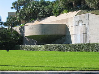
Fort Crockett is a government reservation on Galveston Island overlooking the Gulf of Mexico originally built as a defense installation to protect the city and harbor of Galveston and to secure the entrance to Galveston Bay, thus protecting the commercial and industrial ports of Galveston and Houston and the extensive oil refineries in the bay area. The facility is now managed by the US NOAA National Marine Fisheries Service, and hosts the Bureau of Commercial Fisheries Laboratory, the Texas Institute of Oceanography, as well as some university facilities. The area still contains several historical buildings and military fortifications.

The George and Cynthia Mitchell Memorial Causeway is a set of causeways in Galveston, Texas, United States. Two of the routes carry the southbound and northbound traffic of Interstate 45, while the original causeway is restricted to rail traffic. It is the main roadway access point to Galveston Island. The second access point is Bolivar Ferry.

The United States Customs House and Court House, also known as Old Galveston Customhouse, in Galveston, Texas, is a former home of custom house, post office, and court facilities for the United States District Court for the Eastern District of Texas, and later for the United States District Court for the Southern District of Texas. Completed in 1861, the structure is now leased by the General Services Administration to the Galveston Historical Foundation. The courthouse function was replaced in 1937 by the Galveston United States Post Office and Courthouse.

Ashton Villa is a fully restored, historic home located on the corner of 24th and Broadway in Galveston, Texas, United States. Constructed in 1859, it was one of the first brick structures in Texas built by slaves.

The Halfmoon Reef Light is one of the many screw-pile type lighthouses built on the Texas Gulf Coast, but the only one that still stands. To distinguish it from the nearby Matagorda Island Light it was given a red glass chimney to be used with the oil lantern to give it its red beam. Though originally constructed on the bay, the current resting place for the light is on Port Lavaca, alongside Highway 35.
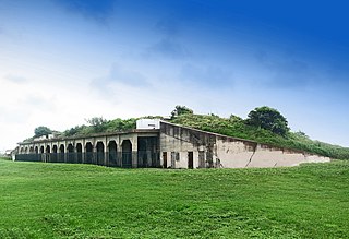
Fort Travis Seashore Park is also the historic Fort Travis, a 60 acres (24 ha) military site with bunkers. The park is located in an area known as Bolivar Point, on the extreme west side of the Bolivar Peninsula in Galveston County, Texas.