Fort Totten State Historic Site

Last updated
Fort Totten
The Fort Totten State Historic Site includes17 original buildings, including one used as an officers quarters during the site's military period.jpg
Buildings at Fort Totten in 2021
USA North Dakota location map.svg
Red pog.svg
Usa edcp location map.svg
Red pog.svg
LocationSouth of Fort Totten off ND 57
Nearest city Fort Totten, North Dakota
Coordinates 47°58′39″N98°59′35″W / 47.97750°N 98.99306°W / 47.97750; -98.99306 Coordinates: 47°58′39″N98°59′35″W / 47.97750°N 98.99306°W / 47.97750; -98.99306
Area9.81 acres (3.97 ha)
Built1868
Website Official website
NRHP reference No. 71000629 [1]
Added to NRHPDecember 9, 1971

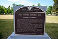
Fort Totten State Historic Site is a historic fort that sits on the shores of Devils Lake near Fort Totten, North Dakota. During its 13 years of operation as a fort, Fort Totten was used during the American Indian wars to enforce the peace among local Native American tribes and to protect transportation routes. After its closing in 1890, it operated until 1959 as a Native American boarding school, called the Fort Totten Indian Industrial School. It was added to the National Register of Historic Places in 1971; in its nomination form, the State Historical Society of North Dakota called it "one of the best preserved military posts... in the Trans-Mississippi West for the Indian Wars period". [2]

Contents

History

Fort Totten

Fort Totten was one of nearly 150 forts constructed across the American western frontier during the American Indian wars. Following the conclusion of the Dakota War of 1862, several displaced Dakota people (who now form the Spirit Lake Tribe) had been relocated to the area around Devils Lake. During the mid-1860s, Major General John Pope had put forth plans to create a line of forts across the newly formed Dakota Territory. One of these was to be located on the shores of Devils Lake. Although Pope canceled his plans for this fort in the fall of 1864, efforts to establish a military foothold there were revitalized in early 1867. This was due to a new treaty signed by the Sissetons and Wahpetons that established two new reservations in Dakota Territory: Lake Traverse Indian Reservation to the south and Devils Lake Indian Reservation (now the Spirit Lake Indian Reservation) in the north. [3] The latter was to be a 240,000-acre (97,000 ha) reservation encompassing the southern shore of Devils Lake. [4] Fort Totten was officially established by the Secretary of War on July 17, 1867. It was named for United States Army Corps of Engineers head Joseph Gilbert Totten. [5]

Early Fort Totten, 19th century LIBI 00007 04955; AN ALBUMEN PHOTOGRAPH (MOUNTED ON CARD) OF FORT TOTTEN; PRODUCED BY UNKNOWN PHOTOGRAPHER, AND ON UNKNOWN DATE (3fcbf43078504e359e4da296316cc1ec).tif
Early Fort Totten, 19th century

The Spirit Lake Tribe had faced severe hardship since arriving in the region, and the winter of 1866–1867 had been particularly difficult. As such, the first missions of the fort were to support the tribe and offer protection from raids. [3] The initial fort was meant to be temporary and was quickly constructed out of oak logs surrounded by an 18-foot-tall (5.5 m) log stockade [2] and spanned about 600 by 400 feet (180 by 120 m). [3] This lumber was provided by a sawmill at nearby Fort Stevenson. [3] By 1868, soldiers—United States Army infantrymen who were garrisoned there—were already constructing more permanent buildings, although official authorization from Congress to do this was not granted until April 6, 1869. The new main building was placed about 800 yards (730 m) south of the original log structure and was completed in 1871. The following decade saw a boom of new construction, expanding in a square pattern around a central plaza. This center yard was used for drills and military parades. New buildings included a hospital, mess hall, four barracks, storehouses, and multiple other stores and offices. All of these additions, including the main building, cost about $100,000. Most were built from bricks crafted from locally sourced clay and lime quarried at Devils Lake and placed on stone foundations. Later additions included corrals and stables for horses and livestock, a brewery, and a sutler. Besides one barracks building that was razed by fire, most buildings from this period are still standing and are maintained. [2] In 1873, Companies D and I of the 7th Cavalry Regiment joined the Fort Totten garrison and remained there until the fort's eventual closing; and until its closing, the fort was continuously manned. Soldiers here oversaw the 1874 establishment of the nearby St. Michael's Mission school. [2] Fort Totten was also the gathering point for an expedition to survey the border between the United States and British Canada in the 1870s.[ citation needed ]

As war waned and the threat of raids dwindled, the army struggled to justify its upkeep of a strong military presence across the American frontier. At Fort Totten specifically, the area was so rural that it almost never saw combat. Additionally, the Spirit Lake Tribe had long since become self-sufficient. Indeed, as historian Heather Mulliner writes, "the army’s presence at Totten had become more a nuisance than a source of support." [3] :325 The Spirit Lake Tribe had established their own government and police force, who often clashed with the soldiers at Fort Totten. At the fort, more and more idle soldiers were turning to alcohol and beginning to become unruly. With the army unable to justify its presence on Devils Lake any longer, Fort Totten was decommissioned and abandoned on December 20, 1890. [3]

Boarding school and later history

After its decommissioning, Congress turned over Fort Totten to the Bureau of Indian Affairs, who repurposed it into a Native American boarding school. The new Fort Totten Indian Industrial School focused on assimilating local Native American children into white American society, introducing them to desired ways of life, and cutting them off from their indigenous cultures. [3] Alongside their regular academic studies, additional classes for practical skills were segregated by gender; girls learned homemaking skills, such as cooking and cleaning, while boys were taught industrial skills such as carpentry, woodworking, agriculture, and other trades. [6] Most pupils were from western North Dakota and Montana; most local families, especially those at Spirit Lake, favored St. Michael's Mission due to Fort Totten's rigid structure and English-only curriculum. [3] Meanwhile, classes at St. Michael's Mission were bilingual until 1887. [6] Additionally, Fort Totten imposed harsh punishments on its students for rulebreaking. By 1910, Fort Totten had introduced a system that allowed local students to commute and live at home, rather than boarding. Although this increased enrollments and as such improved the school's revenue, due to financial struggles, the school briefly closed from 1917 to 1919. [3] At its height, Fort Totten Indian Industrial School had as many as 400 pupils enrolled. [7]

By the time the boarding school was founded, the buildings were in dire need of maintenance. Due to the cold but humid climate, the brick buildings had to be frequently painted to keep the structures from crumbling, and the school's pupils supplied most of the manual labor to upkeep the physical school. [3] Several of the original fort buildings were demolished during the boarding school period: the dead house, well house, a guardhouse, and half of one of the mess halls. A gymnasium was constructed over the spot where the destroyed barracks and mess hall had once stood. Hallways were constructed to connect two of the former barracks to two former officers' quarters. [2] A water tower was also built. [3] The Fort Totten Little Theater, built during this time period, also still stands today. [7]

The Fort Totten Little Theater The Fort Totten Little Theater.jpg
The Fort Totten Little Theater

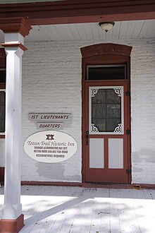
By the time the Great Depression started, the school had partially converted into a day school, with dormitories still maintained for boarding students. [3] Between 1935 and 1939, it hosted a preventorium for Dakota children suffering from tuberculosis. [7] Its financial situation never recovered after the Great Depression, and in 1959, a new campus opened east of the Fort Totten location. On March 6, 1959, [3] Fort Totten ceased operations and the BIA turned the property over to the State Historical Society of North Dakota; its ownership began in 1960. Fort Totten became a North Dakota State Historic Site later that year and was listed on the National Register of Historic Places on December 9, 1971, and the State of North Dakota allocated funds for renovations. Only the buildings and area immediately surrounding the central square are included in the listing, and nothing of the original fort remains outside this area. [2] One of the former officers' quarters was restored and converted into the Totten Trail Historic Inn in 2001 and 2002, which functions both as a hotel and also as a conference and event venue. [7] In 2015, the State of North Dakota and the State Historical Society of North Dakota jointly allocated and raised $600,000 for renovations to the cafeteria/hospital building. [3]

Original First Lieutenant's quarters, now the Totten Trail Historic Inn The Totten Trail Inn at The Historic Fort Totten offers guests the opportunity to immerse themselves in the ambiance of a bygone era.jpg
Original First Lieutenant's quarters, now the Totten Trail Historic Inn

Museum

Visitors can access an interpretive center, take a walking tour of 16 original buildings, visit the Pioneer Daughter's Museum, take in a show at the Fort Totten Little Theatre, and stay at the Totten Trail Historic Inn bed and breakfast. School children often attend the "Fort Totten Living History Field Day" in September.[ citation needed ]

Further reading

Related Research Articles

<span class="mw-page-title-main">Sioux</span> Native American and First Nations ethnic group

The Sioux or Oceti Sakowin are groups of Native American tribes and First Nations peoples in North America. The modern Sioux consist of two major divisions based on language divisions: the Dakota and Lakota; collectively they are known as the Očhéthi Šakówiŋ. The term "Sioux" is an exonym created from a French transcription ("Nadouessioux") of the Ojibwe term "Nadowessi", and can refer to any ethnic group within the Great Sioux Nation or to any of the nation's many language dialects.

<span class="mw-page-title-main">Benson County, North Dakota</span> County in North Dakota, United States

Benson County is a county in the U.S. state of North Dakota. As of the 2020 census, the population was 5,964. Its county seat is Minnewaukan. The county was created on March 9, 1883 by the Dakota Territory legislature, and was named for Bertil W. Benson, a Dakota Territory legislator at the time. The county government was organized on June 4, 1884, and its boundary lines were altered by two legislative actions in 1885.

<span class="mw-page-title-main">Fort Totten, North Dakota</span> CDP in North Dakota, United States

Fort Totten is a census-designated place (CDP) in Benson County, North Dakota, United States. The population was 1,243 at the 2010 census. Fort Totten is located within the Spirit Lake Reservation and is the site of tribal headquarters. The reservation has a total population estimated at 6,000. Although not formally incorporated as a city, Fort Totten has the largest population of any community in Benson County.

<span class="mw-page-title-main">Devils Lake, North Dakota</span> City in North Dakota, United States

Devils Lake is a city in Ramsey County, North Dakota, United States. It is the county seat of Ramsey County. The population was 7,192 at the 2020 census. It is named after the nearby body of water called Devils Lake. The first house in Devils Lake was built in 1882. It was surveyed in 1883 and named Creelsburg and later Creel City, after the surveyor, Heber M. Creel. In 1884 it was renamed Devils Lake.

<span class="mw-page-title-main">Fort Larned National Historic Site</span> National Historic Site of the United States

Fort Larned National Historic Site preserves Fort Larned which operated from 1859 to 1878. It is approximately 5.5 miles (8.9 km) west of Larned, Kansas, United States.

<span class="mw-page-title-main">Fort Tejon</span> United States historic place

Fort Tejon in California is a former United States Army outpost which was intermittently active from June 24, 1854, until September 11, 1864. It is located in the Grapevine Canyon between the San Emigdio Mountains and Tehachapi Mountains. It is in the area of Tejon Pass along Interstate 5 in Kern County, California, the main route through the mountain ranges separating the Central Valley from the Los Angeles Basin and Southern California. The fort's location protected the San Joaquin Valley from the south and west.

<span class="mw-page-title-main">Fort Abraham Lincoln</span> North Dakota state park

Fort Abraham Lincoln State Park is a North Dakota state park located 7 miles (11 km) south of Mandan, North Dakota, United States. The park is home to the replica Mandan On-A-Slant Indian Village and reconstructed military buildings including the Custer House.

Cankdeska Cikana Community College is a public tribal land-grant community college in Fort Totten, North Dakota, on the Spirit Lake Reservation. The college is accredited by the Higher Learning Commission. The college is named after Paul "Little Hoop" Yankton, a Dakota man who fought and died in World War II; his Dakota name was Cankdeska Cikana.

<span class="mw-page-title-main">Crow Creek Indian Reservation</span> Indian reservation in South Dakota, United States

The Crow Creek Indian Reservation, home to Crow Creek Sioux Tribe is located in parts of Buffalo, Hughes, and Hyde counties on the east bank of the Missouri River in central South Dakota in the United States. It has a land area of 421.658 square miles (1,092.09 km2) and a 2000 census population of 2,225 persons. The major town and capital of the federally recognized Crow Creek Sioux Tribe is Fort Thompson.

<span class="mw-page-title-main">Fort Buford</span> United States historic place

Fort Buford was a United States Army Post at the confluence of the Missouri and Yellowstone rivers in Dakota Territory, present day North Dakota, and the site of Sitting Bull's surrender in 1881.

<span class="mw-page-title-main">Wanata</span> 19th century Yanktonai Dakota chief

Wa-na-ta or Waneta was a chief of the Yanktonai, a tribe of the Dakota. Chief Wa-na-ta, also known as Wanata and Wanataan I, was born around 1795. The Yanktonai were located near the St. Peter River, which is today known as the Minnesota River, in present day Minnesota. The Yanktonai were said to have a population between five and six thousand individuals with 1,300 warriors. Wanata was a very influential chief, as evidenced by his ability to lead his tribes' 1,300 warriors into battle.

<span class="mw-page-title-main">Fort Hays</span>

Fort Hays, originally named Fort Fletcher, was a United States Army fort near Hays, Kansas. Active from 1865 to 1889 it was an important frontier post during the American Indian Wars of the late 19th century. Reopened as a historical park in 1929, it is now operated by the Kansas Historical Society as the Fort Hays State Historic Site.

<span class="mw-page-title-main">Spirit Lake Tribe</span> Native American tribal organization in North Dakota

The Spirit Lake Tribe is a federally recognized tribe based on the Spirit Lake Dakota Reservation located in east-central North Dakota on the southern shores of Devils Lake. It is made up of people of the Pabaksa (Iháŋkthuŋwaŋna), Sisseton (Sisíthuŋwaŋ) and Wahpeton (Waȟpéthuŋwaŋ) bands of the Dakota tribe. Established in 1867 in a treaty between Sisseton-Wahpeton Bands and the United States government, the reservation, at 47°54′38″N98°53′01″W, consists of 1,283.777 square kilometres (495.669 sq mi) of land area, primarily in Benson and Eddy counties. Smaller areas extend into Ramsey, Wells and Nelson counties.

<span class="mw-page-title-main">James McLaughlin (Indian agent)</span>

James McLaughlin was a Canadian-American United States Indian agent and inspector, best known for having ordered the arrest of Sitting Bull in December 1890, which resulted in the chief's death and contributed to the Wounded Knee Massacre. Before this event, he was known for his positive relations with several tribes. His memoir, published in 1910, was entitled, My Friend the Indian.

<span class="mw-page-title-main">Sisseton Wahpeton Oyate</span>

The Sisseton Wahpeton Oyate of the Lake Traverse Reservation, formerly Sisseton-Wahpeton Sioux Tribe/Dakota Nation, is a federally recognized tribe comprising two bands and two subdivisions of the Isanti or Santee Dakota people. They are on the Lake Traverse Reservation in northeast South Dakota.

Mission Township is a civil township in Benson County, North Dakota, United States. As of the 2000 census, its population was 1,077. It is the most populous township in the county.

<span class="mw-page-title-main">American Indian boarding schools</span> Residential schools established to assimilate Native American children into a white American society

American Indian boarding schools, also known more recently as American Indian residential schools, were established in the United States from the mid-17th to the early 20th centuries with a primary objective of "civilizing" or assimilating Native American children and youth into European American culture. In the process, these schools denigrated Native American culture and made children give up their languages and religion. At the same time the schools provided a basic Western education. These boarding schools were first established by Christian missionaries of various denominations. The missionaries were often approved by the federal government to start both missions and schools on reservations, especially in the lightly populated areas of the West. In the late 19th and early 20th centuries especially, the government paid religious orders to provide basic education to Native American children on reservations, and later established its own schools on reservations. The Bureau of Indian Affairs (BIA) also founded additional off-reservation boarding schools based on the assimilation model. These sometimes drew children from a variety of tribes. In addition, religious orders established off-reservation schools.

<span class="mw-page-title-main">Bureau of Indian Education</span> United States government agency

The Bureau of Indian Education (BIE), headquartered in the Main Interior Building in Washington, D.C., and formerly known as the Office of Indian Education Programs (OIEP), is a division of the U.S. Department of the Interior under the Assistant Secretary for Indian Affairs. It is responsible for the line direction and management of all BIE education functions, including the formation of policies and procedures, the supervision of all program activities, and the approval of the expenditure of funds appropriated for BIE education functions.

<span class="mw-page-title-main">Fort McKinney (Wyoming)</span> United States historic place

Fort McKinney (1877–1894) was a military post located in North Eastern Wyoming, near the Powder River.

<span class="mw-page-title-main">Fort Apache Historic Park</span> Historic place in Gila County, Arizona

Fort Apache Historic Park is a tribal historic park of the White Mountain Apache, located at the former site of Fort Apache on the Fort Apache Indian Reservation. The park interprets the rich and troubled history of relations between the Apache and other Native American tribes at the fort, which was converted into a Bureau of Indian Affairs boarding school after its military use ended. The park, which covers 288 acres (117 ha) of the former fort and school, as well as a nearby military cemetery, form the National Historic Landmark Fort Apache and Theodore Roosevelt School historic district.

References

  1. "National Register Information System". National Register of Historic Places . National Park Service. March 13, 2009.
  2. 1 2 3 4 5 6 Sperry, James E. (October 28, 1971). "National Register of Historic Places Inventory/Nomination: Fort Totten". National Park Service . Retrieved January 19, 2022. With accompanying pictures
  3. 1 2 3 4 5 6 7 8 9 10 11 12 13 14 Mulliner, Heather (December 2019). "Two Posts, Two Pasts: Preserving Forts Sisseton and Totten". South Dakota History. 49 (4): 308–333.
  4. Hansen, Karen V.; Osterud, Grey; Grim, Valerie (Summer 2018). ""Land Was One of the Greatest Gifts": Women's Landownership in Dakota Indian, Immigrant Scandinavian, and African American Communities". Great Plains Quarterly. 38 (3): 251–272. doi:10.1353/gpq.2018.0041. JSTOR   26535381. S2CID   165570837 . Retrieved January 20, 2022.
  5. Robert W. Frazer: Forts of the West, Military Forts and Presidios and Posts Commonly Called Forts West of the Mississippi River to 1898, University of Oklahoma Press, Norman, Okla., 1965, p. 115.
  6. 1 2 Carroll, James T. (Winter 2009). "The Smell of the White Man Is Killing Us: Education and Assimilation among Indigenous Peoples". Comparative Studies of Native American Catholics. 27 (1): 21–48. JSTOR   27671173 . Retrieved January 20, 2020.
  7. 1 2 3 4 Bonham, Kevin (January 4, 2016). "Fort Totten, deemed one of the best-preserved frontier military forts in the nation, continues to tell its story". Grand Forks Herald. Forum Communications. Retrieved January 19, 2022.
HABS—Historic American Buildings Survey of Fort Totten