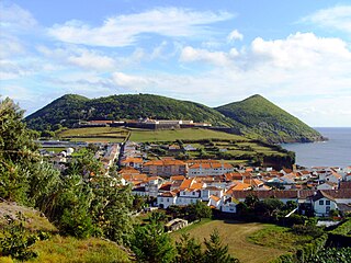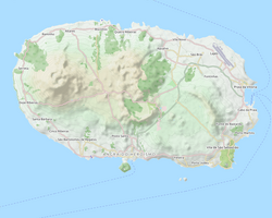
Angra do Heroísmo, or simply Angra, is a city and municipality on Terceira Island, Portugal, and one of the three capital cities of the Azores. Founded in 1478, Angra was historically the most important city in the Azores, as seat of the Bishop of the Azores, government entities, and having previously served as the capital city of Portugal during the Liberal Wars. The population in 2011 was 35,402, in an area of 239.00 km². It was classified as a World Heritage site by UNESCO in 1983.

São Mateus da Calheta is a civil parish within the municipality of Angra do Heroísmo in the Portuguese archipelago of the Azores. The population in 2011 was 3,757, in an area of 5.98 km2. It is located on the periphery of the urbanized area of the city of Angra do Heroísmo, and developed from a small fishing port in a bay along the volcanic coast of the island.

The Fortress of São João Baptista, also known as the Fort of São Filipe or Fort of Monte Brasil is a historic fortress and defensive emplacement, located in the civil parish of Sé, municipality of Angra do Heroísmo in the Portuguese island of Terceira, archipelago of the Azores.

The Castle of Moinhos, officially known as the Castle of São Cristóvão, or Castle/Fort of São Luís is the name of the ruins of 16th-century fortification in city of Angra, on the Portuguese island of Terceira in the archipelago of the Azores. It is primarily known as the Castle of Moinhos, owing to the popular name given to the site for the number of mills that dotted the hilltop, on which the castle was erected.

The Fort of Negrito is a 16th-century maritime fort situated in the civil parish of São Mateus da Calheta, in the municipality of Angra do Heroísmo on the island of Terceira, Azores, Portugal.

Fortress of São Mateus da Calheta is a fort in the civil parish of São Mateus da Calheta, in the municipality of Angra do Heroísmo, island of Terceira, in the Portuguese archipelago of the Azores.

The Fort of the Maré, ruins of a 16th-century fortification located in the civil parish São Mateus da Calheta, in the municipality of Angra do Heroísmo, along the southern coast of Terceira, Portuguese archipelago of the Azores.

The Fort of Má Ferramenta, near the port of the civil parish of São Mateus da Calheta, municipality of Angra do Heroísmo, along the southern coast of the Portuguese island of Terceira, in the archipelago of the Azores. Located in a dominant position over this coastal stretch of coast that sheltered anchored ships, it was a fortification used as a defence against attacks from pirates and corsairs, that frequented the waters of the mid-Atlantic.

Fort of São João, also known as Fort of Biscoitinho, is a medieval fort, in the civil parish of São Mateus da Calheta, in the municipality of Angra do Heroísmo, on the Portuguese archipelago of the Azores.

The Fort of Cinco Ribeiras, also known as the Fort of Nossa Senhora do Pilar or Fort of São Bartolomeu, ruins of a 16th-century fortification located in the municipality of Angra do Heroísmo, along the southeast coast of Terceira, Portuguese archipelago of the Azores.
The Fort of the Açougue, ruins of a 16th-century fortification located in the municipality of Angra do Heroísmo, along the southern coast of Terceira, Portuguese archipelago of the Azores.

The Fort of Santo António, also known as the Redoubt of Santo António, is located on the peninsula of Monte Brasil, in the civil parish Sé, in the municipality of Angra do Heroísmo, along the southern coast of Terceira, Portuguese archipelago of the Azores. It is part of the complex of defensive structures of the Fort of São João Baptista, that crossed-fire with the Fort of São Sebastião in the defense of the Bay of Angra.
The Fort of the Caninas, is a medieval fort situated in the Portugueses civil parish of Porto Judeu, municipality of Angra do Heroísmo, in the archipelago Azores.
Fort of the Cavalas is a fort situated in the civil parish of São Sebastião in the municipality of Angra do Heroísmo, in the Portuguese archipelago of the Azores.

The Dois Paus redoubt is a redoubt fortification situated on the peninsula of Monte Brasil, in the civil parish of Sé, in the municipality of Angra do Heroísmo, in the Porutguese archipelago of the Azores. It was part of the fortified defenses of the Fortress of São João Baptista.

The Três Paus redoubt is a redoubt fortification situated on the peninsula of Monte Brasil, in the civil parish of Sé, in the municipality of Angra do Heroísmo, in the Portuguese archipelago of the Azores. Part of the fortified defenses of the Fortress of São João Baptista, it was also known as the Fort/Redoubt of Benedict the Moor.

Fort of Santa Cruz, is a 16th-century fortification located in the civil parish of Angústias, municipality of Horta, on the island of Faial in the Portuguese Azores. Occasionally referred to as the Castelo de Santa Cruz by locals, it is situated in the historic centre of the city, on the edge of Horta Bay. It was constructed to work in conjunction with the Fort of Bom Jesus at the mouth of the Ribeira da Conceição and Fort of Greta along the coast of the extinct spatter cone Monte da Guia, to defend the entrance to the harbour and southern access to the Bay.

The Fort of Greta is a medieval fortification, whose remnants are located on the cinder cone of Monte da Guia, along the southern coast of the civil parish of Angústias, in Horta, island of Faial, in the Portuguese Azores.

The Fort of the Espírito Santo is the remains of a 16th-century fortification located on the extreme northern edge of the Bay of Praia da Vitória, in the Portuguese civil parish of Santa Cruz, municipality of Praia da Vitória, on the island of Terceira, in the Azores.
The Fort of Greta is a fort along the promontory of Santa Catarina, on the western edge of the Bay of Mós, in the civil parish of Vila de São Sebastião, in the municipality of Angra do Heroísmo, on the Portuguese archipelago of the Azores.


