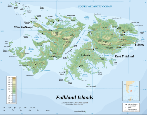
The Falkland Sound is a sea strait in the Falkland Islands. Running southwest-northeast, it separates West and East Falkland.

UTC−03:00 is an identifier for a time offset from UTC of −03:00.
No Man's Land is an area on East Falkland island, in the Falkland Islands. It probably derives its name from its extremely rough ground, and is partly co-extensive with the Wickham Heights. It lies to the north-west of RAF Mount Pleasant, on the northern half of East Falkland.

Fox Bay is the second largest settlement on West Falkland in the Falkland Islands. It is located on a bay of the same name, and is on the south east coast of the island. It is often divided into Fox Bay East ("FBE") and Fox Bay West ("FBW") making it two settlements: combined, these make the largest settlement on West Falkland, but if separated, Port Howard is the largest. Fox Bay takes its name, like the Warrah River, from the Falkland fox, an animal locally called the warrah and now extinct.

Johnson's Harbour is a settlement on the north east coast of East Falkland in the Falkland Islands. It is on the shore of Berkeley Sound at the head of Chabot Creek on a bay also named Johnson's Harbour. It has a small store but the FIGAS only lands there for emergencies. Surrounding hills include North Lookout, Diamond Mountain and Hawk Hill.
Green Patch is a settlement on East Falkland, in the Falkland Islands, It is on the north east coast, on the south shore of Berkeley Sound, a few miles south east from Port Louis, on Port Louis Harbour. It looks out onto Long Island and Hog Island.

Concordia Bay is on the north shore of East Falkland in the Falkland Islands. It is between Foul Bay and Salvador Water. It is also near Cape Dolphin, and the northern end of the Falkland Sound.
Cape Bougainville is the second–most northerly point on East Falkland, Falkland Islands, after Cape Dolphin, and is the second most northerly point of the two main islands, East and West Falkland. Many of the smaller islands, such as the Jason Islands are further north.

Mount Kent is a mountain on East Falkland, Falkland Islands, It is north of Mount Challenger and saw action in the Falklands War during the Battle of Mount Harriet – some of the area is still mined. The mountain's top is occupied by the RRH Mount Kent of the British Forces South Atlantic Islands (BFSAI), part of an early warning and airspace control network including also RRH Mount Alice and RRH Byron Heights on West Falkland.
Pleasant Peak is a location on the Falkland Islands, East Falkland, two miles (3.2 km) north of RAF Mount Pleasant.
New Haven is an inlet in the Falkland Islands. It is situated on the west coast of East Falkland, facing Falkland Sound, the stretch of water which divides East Falkland from West Falkland.

Bertha's Beach Important Bird Area comprises 3300 ha of coastal wetlands at the entrance to Choiseul Sound, on the east coast of East Falkland, in the Falkland Islands. It lies about 8 km south-east of Mount Pleasant Airport and 40 km south-west of Stanley. It has been identified by BirdLife International as an Important Bird Area (IBA) because of its significancer for a variety of migratory waders and other waterbirds. Overlapping it is the 4000 ha Bertha's Beach Ramsar site, recognising it as a wetland of international importance.
Seal Bay is a bay, about 1 km across, on the rugged and exposed north coast of East Falkland in the Falkland Islands of the South Atlantic Ocean. It lies some 40 km north-west of Stanley.

Swan Point is the point on the southwest side of the entrance to Queen Charlotte Bay, forming the northeast extremity of Weddell Island in the Falkland Islands.
Weddell Settlement is the only settlement on Weddell Island in the Falkland Islands, situated on the east coast of the island at the head of the sheltered Gull Harbour, part of Queen Charlotte Bay. It is located at 51°53′46″S60°54′27″W, which is 12.15 kilometres (7.55 mi) northeast of Race Point, 15 kilometres (9.3 mi) south by west of Swan Point, 212 kilometres (132 mi) west-southwest of Stanley and 56.6 kilometres (35.2 mi) west of Fox Bay on West Falkland.
Chatham Harbour is the large bay indenting the central part of Weddell Island in the Falkland Islands. It is entered east of Beacon Point and west of Loop Head. The 3 km wide bay extends 5 km in southeast direction, this part of the feature forming an anchorage named Bald Road, and north of Clay Point turning for 10 km in southwest direction. Chatham Harbour is centred at 51°50′16″S60°57′32″W.
French Harbour is the 500 m wide bay indenting for 3.1 km the west coast of Weddell Island in the Falkland Islands. It is entered 5.5 km north of Weddell Point, and centred at 51°51′03″S61°06′50″W.
Gull Harbour is the 1.3 km wide bay indenting for 2.8 km the east coast of Weddell Island in the Falkland Islands. It is entered north of Gull Point and south of Mark Point, and is centred at 51°53′56″S60°53′20″W. The principal settlement of the island, Weddell Settlement, is situated at the head of the bay. Until the mid-nineteenth century Gull Harbour was known as Great Harbour.
Quaker Harbour is the irregularly shaped bay indenting for 3.7 km the north coast of Weddell Island in the Falkland Islands. It is centred at 51°49′00″S61°04′35″W, and has its head fed by Pitt Creek. The bay takes its name from nearby Quaker Island.
New Year Cove is the 1.7 km wide bay indenting for 2.45 km the southeast coast of Weddell Island in the Falkland Islands. It is entered north of Hadassah Point and south of Circum Point and centred at 51°56′30″S60°54′30″W.