
Denali is the highest mountain peak in North America, with a summit elevation of 20,310 feet (6,190 m) above sea level. It is the tallest mountain in the world from base-to-peak on land, measuring 18,000 ft (5,500 m), With a topographic prominence of 20,194 feet (6,155 m) and a topographic isolation of 4,621.1 miles (7,436.9 km), Denali is the third most prominent and third-most isolated peak on Earth, after Mount Everest and Aconcagua. Located in the Alaska Range in the interior of the U.S. state of Alaska, Denali is the centerpiece of Denali National Park and Preserve.

The Saint Elias Mountains are a subgroup of the Pacific Coast Ranges, located in southeastern Alaska in the United States, Southwestern Yukon and the very far northwestern part of British Columbia in Canada. The range spans Wrangell-St. Elias National Park and Preserve in the United States and Kluane National Park and Reserve in Canada and includes all of Glacier Bay National Park in Alaska. In Alaska, the range includes parts of the city/borough of Yakutat and the Hoonah-Angoon and Valdez-Cordova census areas.
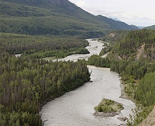
The Matanuska River (Dena'ina: Ch'atanhtnu; Ahtna: Ts'itonhna’) is a 75-mile (121 km) long river in Southcentral Alaska, United States. The river drains a broad valley south of the Alaska Range eponymously known as the Matanuska Valley.

Mount Blackburn is the highest peak in the Wrangell Mountains of Alaska in the United States. It is the fifth-highest peak in the United States and the twelfth-highest peak in North America. The mountain is an old, eroded shield volcano, the second-highest volcano in the U.S. behind Mount Bona and the fifth-highest in North America. It was named in 1885 by Lt. Henry T. Allen of the U.S. Army after Joseph Clay Stiles Blackburn, a U.S. senator from Kentucky. It is located in the heart of Wrangell – St. Elias National Park, the largest national park in the country.
Kennicott Glacier is a glacier in the U.S. state of Alaska. It trends southeast 43 km (27 mi) from Mount Blackburn to its terminus at the head of the Kennicott River in the Wrangell Mountains. It is located in Wrangell-St. Elias National Park near the small town of McCarthy, Alaska and the historic ghost town of Kennecott, Alaska.

The Harvard Glacier is a large tidewater glacier in the Alaska's Prince William Sound. The glacier has a 1.5-mile (2 km) wide face where it calves into the College Fjord. It is 300 ft thick and covers 120,000 acres of Chugach National Forest. The Harvard Glacier is the second largest glacier in the Prince William Sound, after the Columbia Glacier. It is a popular destination of cruise ships in the Prince William Sound.

Regal Mountain is an eroded stratovolcano or shield volcano in the Wrangell Mountains of eastern Alaska. It is located in Wrangell-Saint Elias National Park about 19 mi (31 km) east of Mount Blackburn, the second highest volcano in the United States, and southeast of the massive Nabesna Glacier. Regal Mountain is the third highest thirteener in Alaska, ranking just behind its neighbor, Atna Peaks. Because the mountain is almost entirely covered in glaciers, no geological studies have been done, but published references state and the geological map shows that the mountain is an old eroded volcanic edifice.
The Twin River is a tributary of the Iskut River in the northwest part of the province of British Columbia, Canada. From its source in Twin Glacier the Twin River flows south for about 11 km (6.8 mi), east of Hoodoo Mountain to the Iskut River north of the Craig River watershed. The Twin River's watershed covers 203 km2 (78 sq mi), and its mean annual discharge is an estimated 16.7 m3/s (590 cu ft/s). The river's watershed's land cover is classified as 77.2% snow/glacier, 9.8% barren, 4.5% conifer forest, and small amounts of other cover.
The Hoodoo River is a tributary of the Iskut River in the northwest part of the province of British Columbia, Canada, located west of Hoodoo Mountain and the Twin River in Cassiar Land District. From its source in Hoodoo Glacier the Hoodoo River flows south for about 10 km (6.2 mi) to the Iskut River northwest of the mouth of the Craig River.
Hoodoo Glacier is a glacier in northwestern British Columbia, Canada, located on the western flank of Hoodoo Mountain. It lies at the headwaters of the Hoodoo River. The glacier originates from the Andrei Icefield.
Twin Glacier is a glacier in northwestern British Columbia, Canada, located on the northern and eastern flanks of Hoodoo Mountain. It lies at the headwaters of the Twin River. The glacier originates from the Andrei Icefield.
Robert Phillip Sharp was an American geomorphologist and expert on the geological surfaces of the Earth and the planet Mars. Sharp served as the chairman of the Division of Geological Sciences at California Institute of Technology (Caltech) from 1952 to 1968. He built the modern department and especially recruited new faculty in geochemistry, tectonic geomorphology, planetary science, and field geology.
Caldwell Glacier is a glacier in the Alaska Range of Denali National Park and Preserve in the U.S. state of Alaska. The glacier begins in the Kichatna Mountains at Gurney Peak and Lewis Peak, moving southwest to become a source of the Kichatna River. Named in 1889 by explorer Lt. J.S. Herron, it is 5 miles (8.0 km) long.
Cul-de-sac Glacier is a glacier in the Alaska Range of Denali National Park and Preserve in the U.S. state of Alaska. The glacier begins in the Kichatna Mountains on the side of Kichatna Spire, moving north. Its run-off and that of neighboring Shelf and Shadows glaciers feeds the west fork of the Yentna River.
Tatina Glacier is a glacier in the Alaska Range of Denali National Park and Preserve in the U.S. state of Alaska. The glacier begins in the Kichatna Mountains on the north side of the Cathedral Spires, moving northeast. Its run-off is the source of the Tatina River.
Shelf Glacier is a glacier in the Alaska Range of Denali National Park and Preserve in the U.S. state of Alaska. The glacier begins in the Kichatna Mountains on the side of Kichatna Spire, moving north. It is a tributary to neighboring Shadows Glacier, which with Cul-de-sac Glacier feeds the west fork of the Yentna River.
Shadows Glacier is a glacier in the Alaska Range of Denali National Park and Preserve in the U.S. state of Alaska. The glacier begins in the Kichatna Mountains on the north side of the Cathedral Spires, moving north. It receives neighboring Shelf Glacier as a tributary, and together with Cul-de-sac Glacier feeds the west fork of the Yentna River.
The Polychrome Glaciers are five glaciers in the Alaska Range of Denali National Park and Preserve in the U.S. state of Alaska. The glaciers originate in parallel glaciated north-trending valleys in the Alaska Range, opposite Polychrome Mountain across Polychrome Pass.
Parlung Tsangpo or Parlung Zangbo, also known as Palongzangbu River, is a river in Nyingchi, Tibet, China. It is the largest tributary on the left side of Yarlung Tsangpo. Its source is the Arza Gongla Glacier, at an elevation of 4900m. It first flows north into Ngagung Tso, then turn northwest to Rakwa Tso. It joins Yarlung Tsangpo near Bomê.
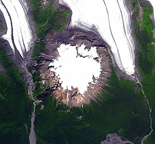
The Andrei Icefield is a large icefield in the Boundary Ranges of the Coast Mountains in northwestern British Columbia, Canada. It is located 130 km (81 mi) northwest of the community of Stewart in Cassiar Land District. The icefield is the source of many valley glaciers, including Hoodoo Glacier and Twin Glacier, which lie at the headwaters of Hoodoo River and Twin River, respectively. Between these two glaciers is Hoodoo Mountain, a flat-topped stratovolcano of the Northern Cordilleran Volcanic Province. Other glaciers originating from the Andrei Icefield include Andrei Glacier, Porcupine Glacier, Johnson Glacier and Choquette Glacier, the latter of which lies at the headwaters of Choquette River.


