The Sweet Auburn Historic District is a historic African-American neighborhood along and surrounding Auburn Avenue, east of downtown Atlanta, Georgia, United States. The name Sweet Auburn was coined by John Wesley Dobbs, referring to the "richest Negro street in the world," one of the largest concentrations of African-American businesses in the United States.

Woodbridge is a historic neighborhood of primarily Victorian homes located in Detroit, Michigan. The district was listed on the National Register of Historic Places in 1980, with later boundary increases in 1997 and 2008. In addition to its historic value, Woodbridge is also notable for being an intact neighborhood of turn-of-the-century homes within walking or biking distance of Detroit's Downtown, Midtown, New Center, and Corktown neighborhoods.

The Occidental Life Building is a historic office building in Albuquerque, New Mexico, in the United States. Featuring an unusual Venetian Gothic Revival architectural style inspired by the Doge's Palace in Venice, the building is one of the city's most recognizable landmarks and has been described as "unique in the country".

This is intended to be a complete list of the properties and districts on the National Register of Historic Places in Fairfield County, Connecticut, United States. The locations of National Register properties and districts for which the latitude and longitude coordinates are included below may be seen in an online map.

Downtown Albuquerque is the central business district of Albuquerque, New Mexico, United States. It is where a significant number of the city's highrise buildings are located, and is the center of government and business for the Greater Albuquerque metropolitan region.

The historic U.S. Route 66 (US 66) ran east–west across the central part of the state of New Mexico, along the path now taken by Interstate 40 (I-40). However, until 1937, it took a longer route via Los Lunas, Albuquerque, and Santa Fe, now roughly New Mexico State Road 6 (NM 6), I-25, and US 84. Large portions of the old road parallel to I-40 have been designated NM 117, NM 118, NM 122, NM 124, NM 333, three separate loops of I-40 Business, and state-maintained frontage roads.

Downtown Santa Ana (DTSA), also called Downtown Orange County, is the city center of Santa Ana, the county seat of Orange County, California. It is the institutional center for the city of Santa Ana as well as Orange County, a retail and business hub.

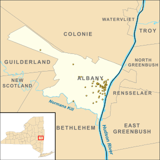
There are 77 properties listed on the National Register of Historic Places in Albany, New York, United States. Six are additionally designated as National Historic Landmarks (NHLs), the most of any city in the state after New York City. Another 14 are historic districts, for which 20 of the listings are also contributing properties. Two properties, both buildings, that had been listed in the past but have since been demolished have been delisted; one building that is also no longer extant remains listed.

The Barelas-South Fourth Street Historic District is a historic district in Albuquerque, New Mexico which encompasses the commercial district along 4th Street in the Barelas neighborhood. The district extends from Stover Avenue in the north to Bridge Boulevard in the south, covering a distance of about 0.6 miles (0.97 km). It contains 45 contributing buildings, mostly automobile-oriented commercial buildings constructed between 1925 and 1956, though some houses which predate the commercial development are also present. The section of 4th Street included in the district was part of U.S. Route 66 from 1926 to 1937 and was also the main commercial area in Barelas.

The McCanna–Hubbell Building, also known as the AG&E Building, is a historic commercial building in downtown Albuquerque, New Mexico. Built in 1915, it is a two-story brick structure with a prominent cornice. From 1917 to the mid-1960s the building was the headquarters of the Albuquerque Gas & Electric Company, which later became the Public Service Company of New Mexico (PNM). During this period the piers and cornice of the building were decorated with hundreds of electric light bulbs, the sockets for which are still in place. PNM later moved two blocks south to the PNM Building on Silver Avenue.

Huning Highlands, also known as EDo or East Downtown, is an inner-city neighborhood in Albuquerque, New Mexico, directly east of Downtown. It is a mostly residential area known for its high concentration of Victorian and early 20th-century houses and is listed on the National Register of Historic Places as the Huning Highlands Historic District. There is also a commercial district along the main thoroughfares, Central Avenue and Broadway Boulevard. Huning Highlands was developed starting in 1880 and is named for Franz Huning, a prominent businessman at the time.

The La Luz Historic District is a 18 acres (7.3 ha) historic district in La Luz, Otero County, New Mexico, which was listed on the National Register of Historic Places in 1980. The district included 27 contributing buildings.

Hoffmantown Baptist Church is a historic church building in the Northeast Heights of Albuquerque, New Mexico. The church was built in 1965 in the New Formalist architectural style. After being outgrown by its original congregation, the building has been home to God's House Church since 1997. It was listed on the New Mexico State Register of Cultural Properties and the National Register of Historic Places in 2019.

The Lembke House is a historic house in Albuquerque, New Mexico, and one of the best examples of residential International Style architecture in the city. It was built in 1937 by Charles H. Lembke (1889–1989), a local construction company owner who was also Chairman of the City Commission during the time he occupied the house. It was one of the earlier houses in the Huning Castle neighborhood, an area of large homes that was mostly developed between the 1930s and 1950s. The house was probably constructed as a speculative venture as Lembke lived there for less than a year before selling it. The house was added to the New Mexico State Register of Cultural Properties in 1976 and the National Register of Historic Places in 1980.

The John Pearce House is a historic house in Albuquerque, New Mexico. It is notable for its architecture and as the only extant house on the Downtown section of Central Avenue, which is otherwise occupied entirely by commercial buildings. The house was built in 1905 by Dr. John F. Pearce, one of the city's first physicians. The contractor, Wallace Hesselden, also built the Henry Mann House the same year. After Pearce moved out of the house in 1933, it was used for various functions including a boarding house and chiropractic clinic. In 1982, the house was renovated and converted to office space. The architect for the renovation was Antoine Predock. The property was added to the New Mexico State Register of Cultural Properties and the National Register of Historic Places in 1980. It is next door to another historic structure, the Skinner Building.

The Huning Highlands Historic District is a historic district in Albuquerque, New Mexico which encompasses the entirety of the Huning Highlands neighborhood. The district is bounded by Dr. Martin Luther King Jr. Avenue to the north, Locust Street to the east, Iron Avenue to the south, and the Burlington Northern Santa Fe railroad tracks to the west, covering an area of about 0.3 square miles (0.78 km2). The neighborhood was Albuquerque's first residential subdivision and was mostly developed between the 1880s and 1920s. It is known for its high concentration of Victorian and early 20th-century houses. The district was added to the New Mexico State Register of Cultural Properties in 1976 and the National Register of Historic Places in 1978.

The Downtown Neighborhood is a neighborhood in Albuquerque, New Mexico, located between Downtown and Old Town. It is sometimes known as the Fourth Ward based on Albuquerque's former system of political wards. The neighborhood is a mostly residential area consisting largely of single-family dwellings in various sizes and styles constructed between the 1880s and 1940s. There is also a commercial district along Central Avenue which has been branded since 2017 as West Downtown.
The Aldo Leopold Neighborhood Historic District is a historic district in Albuquerque, New Mexico, which comprises a single block on the west side of 14th Street immediately south of Central Avenue. It is notable for its Craftsman/Bungalow-style houses and as the residence of noted naturalist Aldo Leopold. The district makes up the northernmost section of the Huning Place addition, which was platted in 1913 from a section of the large estate formerly belonging to merchant Franz Huning. The eight houses in the district, all of which are contributing properties, were built between 1913 and 1920. The district was added to the New Mexico State Register of Cultural Properties and the National Register of Historic Places in 2002. Aldo Leopold's house at 135 14th St. is also individually listed on the State Register with reference number 1786.

The Eighth Street–Forrester Historic District is a historic district in the Downtown Neighborhood of Albuquerque, New Mexico which primarily encompasses the two parallel streets Eighth Street and Forrester Avenue between Lomas Boulevard and Mountain Road. The district is almost entirely residential, consisting mainly of well preserved lower-middle-class homes built between 1905 and 1915. Most of the houses are modest examples of the "Hipped Box" form, while the Queen Anne, Bungalow, and southwest vernacular styles are also represented. The district was added to the New Mexico State Register of Cultural Properties in 1979 and the National Register of Historic Places in 1980.


