
Hereford is a cathedral city and the county town of Herefordshire, England. It lies on the River Wye, approximately 16 miles (26 km) east of the border with Wales, 23 miles (37 km) north-west of Gloucester and 24 miles (39 km) south-west of Worcester. With a population of 53,112 in 2021, it is the largest settlement in Herefordshire.

The River Wye is the fourth-longest river in the UK, stretching some 250 kilometres from its source on Plynlimon in mid Wales to the Severn estuary. For much of its length the river forms part of the border between England and Wales. The Wye Valley is designated an Area of Outstanding Natural Beauty. The Wye is important for nature conservation and recreation, but is affected by pollution.

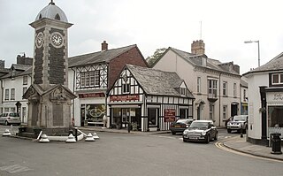
Ross-on-Wye is a market town and civil parish in Herefordshire, England, near the border with Wales. It had a population estimated at 10,978 in 2021. It lies in south-east of the county, on the River Wye and on the northern edge of the Forest of Dean.

Herefordshire is a ceremonial county in the West Midlands of England. It is bordered by Gloucestershire to the south-east, Worcestershire to the east, Shropshire to the north and the Welsh counties of Monmouthshire and Powys to the west. The city of Hereford is the largest settlement and the county town.
Rhayader is a market town and community in Powys, Wales, within the historic county of Radnorshire. The town is 20 miles (32 km) from the source of the River Wye on Plynlimon, the highest point of the Cambrian Mountains, and is located at the junction of the A470 road and the A44 road 13 miles (21 km) north of Builth Wells and 30 miles (48 km) east of Aberystwyth.

Whitchurch is a village in Herefordshire situated on the A40, connecting nearby Ross-on-Wye to Welsh town Monmouth. It is located within the Wye Valley Area of Outstanding Natural Beauty.

Hereford was, until 2010, a constituency of the House of Commons of the Parliament of the United Kingdom. Since 1918, it had elected one Member of Parliament (MP) by the first-past-the-post voting system.

St Briavels, is a medium-sized village and civil parish in the Royal Forest of Dean in west Gloucestershire, England; close to the England-Wales border, and 5 miles (8 km) south of Coleford. It stands almost 800 feet (240 m) above sea level on the edge of a limestone plateau above the valley of the River Wye, above an ancient meander of the river. To the west, Cinder Hill drops off sharply into the valley. It is sheltered behind the crumbling walls of the 12th century St Briavels Castle.

Brockhampton is a village and civil parish in Herefordshire, England. The village is near the River Wye, 14 kilometres (9 mi) south east of Hereford, 13 kilometres (8 mi) north of Ross-on-Wye, and 16 kilometres (10 mi) south west of Ledbury. The Wye Valley Walk passes through Brockhampton. The parish forms part of the Old Gore ward of Herefordshire Council. Prior to 1998, it had been part of the district of South Herefordshire in Hereford and Worcester. The population of the parish in 2011 was 229.

Ganarew is a village and small civil parish in south Herefordshire, England near the River Wye and the border with Wales. The village is located 0.62 miles (1.00 km) southwest of the village of Whitchurch on the main A40 road, and lies within the electoral ward of Kerne Bridge. The village is about 2 miles (3.2 km) from Monmouth and 8 miles (13 km) from Ross-on-Wye. It contains the Church of St Swithin and Ganarew Manor.
Mordiford is a village and civil parish in Herefordshire, England on the B4224 Hereford to Mitcheldean road 4 miles (6 km) east-southeast of the city of Hereford.

Kinnersley is a village and civil parish in Herefordshire, England. The village is about 5 miles (8 km) east of the Wales-England border and 10 miles (16 km) north-west of Hereford.

The Marches Way is a partially waymarked long-distance footpath in the United Kingdom. It runs for 351 kilometres (218 mi) through the Welsh–English borderlands, traditionally known as the Welsh Marches, and links the cities of Chester in the north and Cardiff in the south.

Longtown is a linear village and parish in Herefordshire, England. The parish includes the village of Clodock and had a population in mid-2010 of 543, increasing to 620 at the 2011 Census.

Foy is a hamlet and civil parish in Herefordshire, England. By road, it is 7 kilometres north of Ross-on-Wye, 23 kilometres south east of Hereford and 27 kilometres south west of Ledbury. Foy, and the further Foy parish hamlet of Ingestone, lies in a loop of the River Wye with the nearest vehicle bridges at Ross and Hoarwithy.

Capler Camp is an Iron Age hill fort located 2.5 km south of Fownhope, Herefordshire.

Bridstow is a village and civil parish in Herefordshire, England, 2 km west of Ross-on-Wye and 17 km south-east of Hereford. The parish is bounded to the east and south by the River Wye. The A40 road linking the M50 motorway to South Wales runs through the parish, crossing the Wye at Bridstow Bridge. The parish had a population of 906 in the 2011 UK census, and an estimated population of 941 in 2018.
Little Birch is a hamlet and civil parish in Herefordshire, England. It is approximately 5 miles (8 km) south from the city and county town of Hereford and 7 miles (11 km) north-west from the market town of Ross-on-Wye. The parish is significant for its Grade II* listed church, and Athelstan Wood, formerly anciently managed but now largely coniferised.

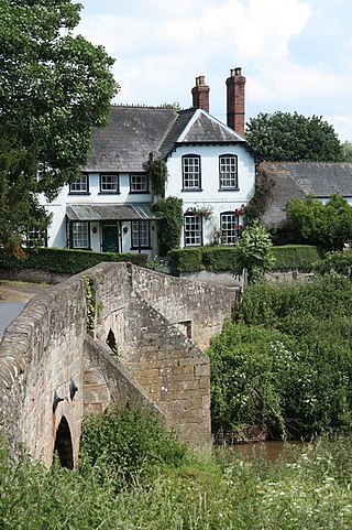
Kerne Bridge was built over the River Wye in the County of Herefordshire, England in 1825–28, on the site of an ancient ford crossing known as Flanesford. It is designated as a Scheduled Monument. Carrying the B4229 road, it connects the parishes of Walford on the river's left bank and Goodrich on the right. It is situated in the heart of the Wye Valley Area of Outstanding Natural Beauty and marks the northern end of the Upper Wye Gorge.

