Admiral Frederick Bullock | |
---|---|
Born | 1788 |
Died | 6 February 1874 |
Allegiance | United Kingdom |
Branch | Royal Navy |
Service years | 1804-1853 |
Rank | Admiral |
Awards | Fellow of the Royal Geographical Society |
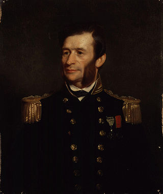
Admiral Frederick Bullock (1788 – 6 February 1874) was a Royal Navy officer noted for his work as a surveyor, particularly in the Thames Estuary.
Bullock entered the Navy on 28 November 1804, serving in HMS Indefatigable under Captains Moore and Rodd in the English Channel. From 1808 he was with HMS Fame in the Mediterranean. He was promoted to Lieutenant on 22 January 1812. [1]
Bullock's first command was HMS Snap, from 1823, surveying the coast of Newfoundland, determining the precise positions of the many headlands that had been well charted by James Cook, but without the aid of chronometers. [2] : 104 He then commanded HMS Echo from 1827 to 1828, surveying in the River Thames. [2] : 195–197 He was promoted to commander in 1829, and served on the yacht William and Mary, on HMS Boxer, and HMS Fearless. [1] He became a Fellow of the Royal Geographical Society in 1830. [1] As commander of Fearless, Bullock was part of the squadron that accompanied Queen Victoria to and from Woolwich on her 1842 visit to Scotland. [3]
Bullock is best-remembered for his surveying of the River Thames and its estuary. A letter from Bullock to Parry, Hydrographer of the Navy in 1828 proposing a detailed survey was rebuffed, but when Francis Beaufort became Hydrographer in 1829 he was much more supportive. Bullock would be engaged on this work until 1847. He started in London, and worked his way down river, using triangulation which connected with the earlier work of the Ordnance Survey. As he moved into the outer estuary, which had been surveyed by Graeme Spence and George Thomas, it became clear that there had been many changes in the shoals and channels, and a new survey of this area was authorised. To obtain accurate positions of shoals and banks out of sight of land, he set up a network of semi-permanent beacons as well as anchored vessels for triangulation, a development of the method earlier used by Thomas. [4]
The changes in the banks and channels of the outer estuary noted by Bullock have continued. In 1839 Bullock surveyed a channel which was named the Bullock Channel. Tizard (1890) reviewed a number of surveys of this channel, including Bullock's and his own. By 1882 it had become wider and deeper, and was buoyed and renamed the Duke of Edinburgh Channel after Alfred, Duke of Saxe-Coburg and Gotha and of Edinburgh, Master of Trinity House. [5] Since that time a shoal has developed that has divided the channel into two, now known as the Edinburgh Channels. [6] [7]
Bullock made a number of technical innovations. On the basis of the temporary beacons he had used in surveying, he designed a more permanent safety beacon which was set up on the dangerous Goodwin Sands, off the Kent coast. [4] In December 1842, during a royal visit to Walmer Castle, Bullmer took Prince Albert in Fearless to visit the beacon. [8] The beacon survived four stormy winters before being demolished by a "careless dutchman" whose ship ran over it at high tide. [9] [4] Bullock was the inventor of an improved form of protractor, [1] and patented a ship's log, for recording a vessel's speed [10]
Bullock retired in 1853, along with several other surveyors, as a result of budget cuts. [2] : 197 He was promoted to admiral on the retired list, and died on 6 February 1874. [1]
The United Kingdom Hydrographic Office (UKHO) is the UK's agency for providing hydrographic and marine geospatial data to mariners and maritime organisations across the world. The UKHO is a trading fund of the Ministry of Defence (MoD) and is located in Taunton, Somerset, with a workforce of approximately 900 staff.
Admiralty charts are nautical charts issued by the United Kingdom Hydrographic Office (UKHO) and subject to Crown Copyright. Over 3,500 Standard Nautical Charts (SNCs) and 14,000 Electronic Navigational Charts (ENCs) are available with the Admiralty portfolio offering the widest official coverage of international shipping routes and ports, in varying detail.
Sir George Henry Richards was Hydrographer of the Royal Navy from 1863 to 1874.
Murdoch Mackenzie, FRS (1712–1797) was a Scottish hydrographer and cartographer. He is known for his survey of the Orkney Islands: the subsequent maps, known as the Mackenzie Charts are still in use. He is also credited with the invention of the station pointer, a navigational and survey tool used to plot the horizontal angle fixes made with a sextant onto charts.
Vice Admiral Sir Henry Mangles Denham was a Royal Navy officer who went on to be Commander-in-Chief, Pacific Station.
Francis Price Blackwood was a British naval officer who while posted at several different locations during his time in the Royal Navy, spent much of his time posted in colonial Australia and was an instrumental pioneer of regions near Australia's east coast and nearby islands.
Thomas Henry Tizard was an English oceanographer, hydrographic surveyor, and navigator.
HMS Vidal was a survey ship of the Royal Navy. She was designed specifically as a surveying vessel, and was the first survey ship to carry a helicopter. In 1955, a group from Vidal formally annexed Rockall in the North Sea to the United Kingdom.
HMS Investigator was a survey brig of the Royal Navy. She performed surveying duties until she was paid off in 1835. She then became a police ship moored on the Thames River. she was broken up in 1857.
Rear-Admiral George Stephen Ritchie CB DSC was a British admiral noted for his cartographic and hydrographic work and as an author of many publications on hydrography. He was Hydrographer of the Navy from 1966 to 1971.
Admiral Jal Cursetji, PVSM was a former Flag Officer in the Indian Navy. He served as the 8th Chief of the Naval Staff (CNS) from 1 March 1976 until 28 February 1979. He was the first hydrographer to serve as the CNS.
John Washington was an officer of the Royal Navy, Hydrographer of the Navy, and a founding member of the Royal Geographical Society of London.
Henry Charles Otter was a Royal Navy officer and hydrographic surveyor, noted for his work in charting Scotland in the mid-19th century. He was active in surveying in the Baltic Sea during the war with Russia (1853-6) and in supporting the laying of the first transatlantic telegraph cable in 1858.
William Hewett was a Royal Navy officer noted for making the first comprehensive survey of the North Sea and for his work on tides.
George Thomas was a Master in the Royal Navy who was one of the early surveyors of the coasts of Great Britain
Vice-Admiral Sir Archibald Day, was an officer in the Royal Navy and Hydrographer of the Navy from 1950-1955. He played an important part in planning the evacuation from Dunkirk in 1940, and wrote a history of the Hydrographic Service.
Rear Admiral Edward James Bedford was a Royal Navy officer noted for his work as a surveyor, particularly in Scotland.
The Edinburgh Channels, formerly a single channel known as the Bullock Channel and then the Duke of Edinburgh Channel are two roughly parallel transverse channels in the Thames Estuary. They used to be important for navigation, providing a deep approach to the River Thames from the south-east through the sandbanks of the estuary. The opening of an alternative channel in 2000 has greatly reduced their use, but having been surveyed and studied extensively over the past two centuries they provide an important example of the processes that shape shallow water landforms.
Edward Killwick Calver was a Captain in the Royal Navy, and hydrographic surveyor. He is particularly noted for his surveying work in the east of Britain, and as the captain of HMS Porcupine, in oceanographic voyages in 1869 and 1870.
Sir Arthur Guy Norris Wyatt KBE CB (1893-1982), often known as Guy Wyatt, was a Royal Navy Officer and Surveyor who was Hydrographer of the Navy in 1945–1950.