Frederiks | |
|---|---|
Town | |
 Frederiks School | |
 Frederiks Location in Denmark  Frederiks Frederiks (Central Denmark Region) | |
| Coordinates: 56°20′23.34″N9°15′9.32″E / 56.3398167°N 9.2525889°E | |
| Country | Denmark |
| Region | Central Denmark (Midtjylland) |
| Municipality | Viborg |
| Founded | 1906 |
| Area | |
| • Urban | 1.36 km2 (0.53 sq mi) |
| Population (2025) [1] | |
| • Urban | 1,803 |
| • Urban density | 1,330/km2 (3,430/sq mi) |
| Time zone | UTC+1 (CET) |
| • Summer (DST) | UTC+2 (CEST) |
| Postal code | 7470 Karup J |
Frederiks is a small Danish town with a population of 1,803 (1 January 2025), [1] on the road between Viborg and Herning. It is located in Viborg Municipality in central Jutland.
Frederiks is located 8 km northeast of Karup, 32 km northeast of Herning, 31 km southeast of Skive and 18 km southwest of Viborg.
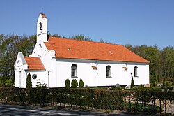
Frederiks Church, built in 1766 as a longhouse, is located on the northwestern outskirts of the town. [2]