Vridsted | |
|---|---|
Village | |
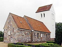 Vridsted Church | |
 Vridsted Location in Denmark  Vridsted Vridsted (Central Denmark Region) | |
| Coordinates: 56°26′32″N9°0′23″E / 56.44222°N 9.00639°E | |
| Country | Denmark |
| Region | Midtjylland |
| Municipality | Viborg |
| Area | |
| • Urban | 0.6 km2 (0.23 sq mi) |
| Population (1. January 2025) [1] | |
| • Urban | 585 |
| • Urban density | 980/km2 (2,500/sq mi) |
| Time zone | UTC+1 (CET) |
| • Summer (DST) | UTC+1 (CEST) |
| Postal code | 7800 |
Vridsted is a village and parish in Viborg Municipality, Central Denmark Region, Denmark. As of 2025, the village has a population of 585. [1] It lies 13 km south of Skive, 23 km west of Viborg and 25 km northeast of Holstebro. The village possesses a primary school, which had 286 students as of 2017, as well as a Min Købmand store and a sports club, Vridsted IF. [2] [3] [4]
Contents
Vridsted is the westernmost town of Viborg Municipality, and borders Holstebro Municipality as well as Karup River (Karup Å). [5]