Related Research Articles

Monroe County Airport is a county-owned public-use airport located three nautical miles (6 km) south of the central business district of Monroeville, in Monroe County, Alabama, United States. According to the FAA's National Plan of Integrated Airport Systems for 2009–2013, it is categorized as a general aviation facility.

Tillamook Airport is a public use airport located 3 miles (4.8 km) south of the central business district of Tillamook, a city in Tillamook County, Oregon, United States. It is owned by the Port of Tillamook Bay. According to the FAA's National Plan of Integrated Airport Systems for 2009–2013, it is categorized as a general aviation facility.
Rock County Airport is a public use airport located two nautical miles southwest of the central business district of Bassett, a city in Rock County, Nebraska, United States. It is owned by the Rock County Airport Authority. According to the FAA's National Plan of Integrated Airport Systems for 2009–2013, it is classified as a general aviation airport.

Marianna Municipal Airport is an airport in Marianna, Jackson County, Florida, 5 miles (8.0 km) northeast of Downtown Marianna. The Federal Aviation Administration (FAA)'s National Plan of Integrated Airport Systems for 2009–2013 categorized it as a general aviation airport. It was formerly Graham Air Base.
Fremont Municipal Airport is a city-owned public-use airport located three nautical miles (6 km) southwest of the central business district of Fremont, a city in Newaygo County, Michigan, United States. The airport is uncontrolled, and is used for general aviation purposes. Skydiving and ultralight activity are also conducted at the field. It is included in the Federal Aviation Administration (FAA) National Plan of Integrated Airport Systems for 2017–2021, in which it is categorized as a local general aviation facility.
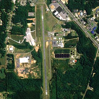
Thomas C. Russell Field is a city-owned public-use airport located two nautical miles (4 km) southwest of the central business district of Alexander City, a city in Tallapoosa County, Alabama, United States.

Weedon Field is a city-owned, public-use airport located three nautical miles north of the central business district of Eufaula, a city in Barbour County, Alabama, United States.

Isbell Field is a city-owned public-use airport located two nautical miles north of the central business district of Fort Payne, a city in DeKalb County, Alabama, United States. According to the FAA's National Plan of Integrated Airport Systems for 2009–2013, it is categorized as a general aviation facility.

Posey Field is a city-owned public-use airport located three nautical miles northeast of the central business district of Haleyville, a city in Winston County, Alabama, United States.

Headland Municipal Airport is a city-owned, public-use airport located two nautical miles northeast of the central business district of Headland, a city in Henry County, Alabama, United States.
Broken Bow Municipal Airport, also known as Keith Glaze Field, is a public use airport located two nautical miles (4 km) north of the central business district of Broken Bow, a city in Custer County, Nebraska, United States. It is owned by the Broken Bow Airport Authority. This airport is included in the National Plan of Integrated Airport Systems for 2011–2015, which categorized it as a general aviation facility.
Shelbyville Municipal Airport is a public use airport located four nautical miles (7 km) northwest of the central business district of Shelbyville, in Shelby County, Indiana, United States. The airport is owned by the city of Shelbyville and is controlled by the mayor and an appointed Board of Commissioners. According to the FAA's National Plan of Integrated Airport Systems for 2009–2013, it was classified as a general aviation airport.
Independence Municipal Airport is a city-owned public-use airport located three nautical miles (6 km) southwest of the central business district of Independence, a city in Buchanan County, Iowa, United States. As per the FAA's National Plan of Integrated Airport Systems for 2009-2013, it is classified as a general aviation airport.
Albion Municipal Airport is a public use airport located three nautical miles (6 km) northwest of the central business district of Albion, in Boone County, Nebraska, United States. It is owned by the Albion Airport Authority. According to the FAA's National Plan of Integrated Airport Systems for 2009–2013, it is classified as a general aviation airport.
Wahoo Municipal Airport is two miles northeast of Wahoo, in Saunders County, Nebraska. It is owned by the Wahoo Airport Authority. The FAA's National Plan of Integrated Airport Systems for 2009–2013 classified it as a general aviation airport.
The O'Neill Municipal Airport is two miles northwest of O'Neill, in Holt County, Nebraska. It is owned by the O'Neill Airport Authority. The FAA's National Plan of Integrated Airport Systems for 2009–2013 categorized it as a general aviation facility.
Russellville Regional Airport is a city-owned public-use airport located two nautical miles (3.7 km) southeast of the central business district of Russellville, a city in Pope County, Arkansas, United States. According to the FAA's National Plan of Integrated Airport Systems for 2009–2013, it is categorized as a general aviation facility. It was formerly known as Russellville Municipal Airport.
Cambridge Municipal Airport is two miles northeast of Cambridge, in Furnas County, Nebraska. The FAA's National Plan of Integrated Airport Systems for 2011–2015 called it a general aviation facility.

Hastings Municipal Airport is two miles northwest of Hastings in Adams County, Nebraska. The National Plan of Integrated Airport Systems for 2011–2015 categorized it as a "general aviation" airport.
York Municipal Airport is a mile northwest of York, in York County, Nebraska. The National Plan of Integrated Airport Systems for 2011–2015 categorized it as a general aviation facility.
References
- 1 2 3 4 FAA Airport Form 5010 for FET PDF , effective 2023-08-10.
- ↑ FAA National Plan of Integrated Airport Systems: 2009-2013