
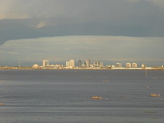
Woodland is the county seat of Yolo County, California, located approximately 15 miles (24 km) northwest of Sacramento, and is a part of the Sacramento - Arden-Arcade - Roseville Metropolitan Statistical Area. The population was 55,468 at the 2010 census.

The Yolo Causeway is a 3.2-mile (5.1 km) long elevated highway viaduct on Interstate 80 that crosses the Yolo Bypass floodplain, connecting the cities of West Sacramento, California and Davis, California. It is officially named the Blecher-Freeman Memorial Causeway after two California Highway Patrol officers who were killed in the line of duty on the causeway.
The Yolo Bypass is one of two flood bypasses in California's Sacramento Valley located in Yolo and Solano Counties. Through a system of weirs, the bypass diverts floodwaters from the Sacramento River away from the state's capital city of Sacramento and other nearby riverside communities.

Cache Creek is an 87-mile-long (140 km) stream in Lake, Colusa and Yolo counties, California.

El Macero is an unincorporated community just outside the city limits of Davis, California, United States, in Yolo County. Until 2006 it had a separate ZIP Code, 95618. In 2006, eastern and southern parts of Davis were added to the 95618 zone. Formerly, a separate post office served El Macero; this is now closed. El Macero was named for Bruce Mace, on whose land it was built. The community is in area code 530. It lies at an elevation of 36 feet. A golf course is in the community.

Capay is an unincorporated community in Yolo County, California. It is located on Cache Creek 2 miles (3.2 km) west-northwest of Esparto, in the Capay Valley, in the northwestern part of the county. Capay's ZIP Code is 95607 and its area code 530. It lies at an elevation of 210 feet. The name Capay comes from the Southern Wintun Indian word for "stream".
Fremont is an unincorporated community in Yolo County, California. It is located on the Sacramento River and Interstate 5 in the east-northeastern portion of the county. Fremont's ZIP Code is 95691 and its area code 530. It is located on the Sacramento Northern and Sacramento and Woodland Railroads 11 miles (18 km) northeast of Davis, at an elevation of 23 feet.
The Golden Empire Council (GEC) is a CA-based nonprofit affiliated with the Boy Scouts of America and it's 'Western Region', 'Area 4'. The council serves a large section of Northern California, primarily the Sacramento Valley and the northern Sierra Nevada mountains. Its boundaries range north to south from Redding, CA to Elk Grove, CA and west to east from Vacaville, CA to Pollock Pines, CA. Its council headquarters and Service Center is located in Sacramento, CA. The council also operates a field office in Chico, CA. Scout Shops selling BSA merchandise are located in both Sacramento and Chico.

The Yolo Bypass Wildlife Area is located within the Yolo Bypass in Yolo County, California. The wildlife area is managed by the California Department of Fish and Wildlife with the intent of restoring and managing a variety of wildlife habitats in the Yolo Basin, a natural basin in the north part of the Sacramento-San Joaquin River Delta. The creation of the wildlife area was spearheaded by the Yolo Basin Foundation. The California Department of Fish and Wildlife and Yolo Basin Foundation are the core partners in the operation of this unique community resource. Located at 38.550515°N 121.626291°W
Cottonwood is a former settlement in Yolo County, California. It was located 2 miles (3.2 km) south of Madison, at an elevation of 164 feet. It still appears on maps as of 1917.
Arcade is an unincorporated community in Yolo County, California. It is located on the Sacramento Northern Railroad 5 miles (8.0 km) Northwest of Clarksburg, at an elevation of 26 feet.
Beatrice is an unincorporated community in Yolo County, California. It is located on the Sacramento Northern Railroad 10.5 miles (17 km) northeast of Davis, at an elevation of 26 feet.
Central is an unincorporated community in Yolo County, California. It is located on the Sacramento Northern Railroad 3 miles (4.8 km) southwest of Clarksburg, at an elevation of 3 feet.
Hershey is an unincorporated community in Colusa and Yolo counties in the U.S. state of California. It is located on the Southern Pacific Railroad 3.25 miles (5.2 km) north-northwest of Dunnigan, at an elevation of 141 feet. It is named after Yolo County's first assemblyman, David N. Hershey.
Norton is an unincorporated community in Yolo County, California. It is located on the Southern Pacific Railroad 4.25 miles (6.8 km) north of Winters, at an elevation of 177 feet.
Riverview is an unincorporated community in Yolo County, California. It lies on the west bank of the Sacramento River, on the Sacramento Northern and the Oakland, Antioch and Eastern Railroads 5 miles (8.0 km) south-southwest of West Sacramento, at an elevation of 16 feet.
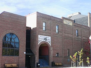
The Woodland Opera House, listed on the National Register of Historic Places and a California Historical Landmark, is one of four fully functioning 19th century opera houses in California. It is a contributing property to the Downtown Historic District of Woodland, California.

Fremont Weir Wildlife Area is 1,461 acres at the north end of the Yolo Bypass floodway along the Sacramento River in Sutter County and Yolo County. It is 6 miles north-east of the city of Woodland and 15 miles north of Yolo Bypass Wildlife Area and the nearby Sacramento Bypass Wildlife Area. Whenever water in the river exceeds the height of the weir the excess flow runs over the weir and down the Yolo Bypass floodway, thereby reducing the risks of flooding in the city of Sacramento and nearby urban areas along the river.


