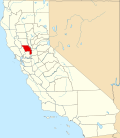
Monument Hills, California

Last updated
Monument Hills
USA California location map.svg
Red pog.svg
Monument Hills
Location in California
Coordinates: 38°39′51″N121°52′32″W / 38.66417°N 121.87556°W / 38.66417; -121.87556 Coordinates: 38°39′51″N121°52′32″W / 38.66417°N 121.87556°W / 38.66417; -121.87556
Country Flag of the United States.svg  United States
State Flag of California.svg  California
County Yolo County
Area
[1]
  Total4.026 sq mi (10.426 km2)
  Land4.026 sq mi (10.426 km2)
  Water0 sq mi (0 km2)  0%
Elevation
[2]
135 ft (41 m)
Population
 (2010)
  Total1,542
  Density380/sq mi (150/km2)

Monument Hills is a census-designated place in Yolo County, California. Monument Hills sits at an elevation of 135 feet (41 m). The 2010 United States census reported Monument Hills's population was 1,542.

Contents

Geography

According to the United States Census Bureau, the CDP covers an area of 4.0 square miles (10.4 km2), all of it land.

Demographics

At the 2010 census Monument Hills had a population of 1,542. The population density was 383.1 inhabitants per square mile (147.9/km2). The racial makeup of Monument Hills was 1,163 (75.4%) White, 20 (1.3%) African American, 32 (2.1%) Native American, 77 (5.0%) Asian, 17 (1.1%) Pacific Islander, 153 (9.9%) from other races, and 80 (5.2%) from two or more races. Hispanic or Latino of any race were 403 people (26.1%). [3]

The whole population lived in households, no one lived in non-institutionalized group quarters and no one was institutionalized.

There were 526 households, 196 (37.3%) had children under the age of 18 living in them, 383 (72.8%) were opposite-sex married couples living together, 30 (5.7%) had a female householder with no husband present, 19 (3.6%) had a male householder with no wife present. There were 23 (4.4%) unmarried opposite-sex partnerships, and 8 (1.5%) same-sex married couples or partnerships. 70 households (13.3%) were one person and 22 (4.2%) had someone living alone who was 65 or older. The average household size was 2.93. There were 432 families (82.1% of households); the average family size was 3.22.

The age distribution was 379 people (24.6%) under the age of 18, 109 people (7.1%) aged 18 to 24, 345 people (22.4%) aged 25 to 44, 552 people (35.8%) aged 45 to 64, and 157 people (10.2%) who were 65 or older. The median age was 42.9 years. For every 100 females, there were 107.3 males. For every 100 females age 18 and over, there were 107.3 males.

There were 575 housing units at an average density of 142.8 per square mile, of the occupied units 451 (85.7%) were owner-occupied and 75 (14.3%) were rented. The homeowner vacancy rate was 3.0%; the rental vacancy rate was 10.7%. 1,302 people (84.4% of the population) lived in owner-occupied housing units and 240 people (15.6%) lived in rental housing units.

Related Research Articles

Bayview, Humboldt County, California Census-designated place in California, United States

Bayview is a census-designated place (CDP) located adjacent to the City of Eureka in Humboldt County, California, United States. Its population is 2,619 as of the 2020 census, up from 2,510 from the 2010 census. Many locals consider this area as part of "Pine Hill."

Tamalpais-Homestead Valley, California Census-designated place in California, United States

Tamalpais-Homestead Valley is a census-designated place (CDP) in Marin County, California, United States. The population was 11,492 at the 2020 census.

El Cerrito, Riverside County, California Census-designated place in Riverside County, California, United States

El Cerrito is a census-designated place (CDP) in Riverside County, California, United States. It is an unincorporated area mostly surrounded by the city of Corona. The population was 5,100 at the 2010 census, up from 4,590 at the 2000 census.

Piñon Hills is a census-designated place in San Bernardino County, California, near the Los Angeles County line. It is located along Pearblossom Highway, 28 miles east of Palmdale, and 15 miles west of the Cajon Pass where Pearblossom Highway meets Interstate 15. The town lies within 25 miles of Hesperia and Victorville. Piñon Hills is in a tri-community that consists of Piñon Hills, Phelan, and Wrightwood. The elevation is 4,173 feet (1,272 m). The population was 7,272 at the 2010 census.

Oak Hills is a census-designated place in the Victor Valley of the Mojave Desert, within San Bernardino County, California.

Minkler is a census-designated place in eastern Fresno County, California. The place is located on Highway 180, 2.25 miles (3.6 km) east-southeast of Centerville and 7.6 miles north of Reedley at an elevation of 397 feet. It has a population of 1,003 people. The town is named for Charles O. Minkler, a local farmer. The current mayor of Minkler is Wyatt Barnett.

Rolling Hills is an unincorporated community and census-designated place (CDP) in Madera County, California, United States, north of Fresno on State Route 41. It lies at an elevation of 371 feet (113 m). The population was 793 at the 2020 census.

Eucalyptus Hills, California Census-designated place in California, United States

Eucalyptus Hills is a census-designated place in San Diego County, California. Eucalyptus Hills sits at an elevation of 627 feet (191 m). The 2010 United States census reported Eucalyptus Hills's population was 5,313.

Kelly Ridge, California Census-designated place in California, United States

Kelly Ridge is a census-designated place in Butte County, northern California.

San Miguel is a census-designated place in Contra Costa County, California. San Miguel sits at an elevation of 249 feet (76 m). The 2010 United States census reported San Miguel's population was 3,392.

Hasley Canyon, California Census-designated place in California, United States

Hasley Canyon is a census-designated place in Los Angeles County, California. Hasley Canyon sits at an elevation of 1,765 feet (538 m). The 2010 United States census reported Hasley Canyon's population was 1,137.

Rose Hills is a census-designated place in Los Angeles County, California. Rose Hills sits at an elevation of 518 feet (158 m) above sea level. The 2010 United States census reported Rose Hills's population was 2,803.

Greeley Hill, California Census-designated place in California, United States

Greeley Hill is a census-designated place in Mariposa County, California, United States. Greeley Hill sits at an elevation of 3,153 feet (961 m) in the foothills of the Sierra Nevada. The 2020 United States census reported Greeley Hill's population as 927.

Indio Hills, California Census-designated place in California, United States

Indio Hills is a census-designated place in Riverside County, California. Indio Hills sits at an elevation of 1,017 feet (310 m). The 2010 United States census reported Indio Hills's population was 972.

Mead Valley is a census-designated place in Riverside County, California. Mead Valley sits at an elevation of 1,663 feet (507 m). The 2010 United States census reported Mead Valley's population was 18,510.

Lemon Hill, California Census-designated place in California, United States

Lemon Hill is a census-designated place in an unincorporated area of Sacramento County, California, south of the city of Sacramento. Lemon Hill sits at an elevation of 30 feet (9.1 m). The 2010 United States census reported Lemon Hill's population was 13,729.

Parkway is a census-designated place in Sacramento County, California. Parkway sits at an elevation of 20 feet (6.1 m). The 2010 United States census reported Parkway's population was 14,670.

Ponderosa is a census-designated place (CDP) in Tulare County, California. Ponderosa sits at an elevation of 7,231 feet (2,204 m). The 2010 United States census reported Ponderosa's population was 16. Ponderosa can be reached from Porterville by 43 curvy miles on a combination of California State Route 190 and the county-maintained Western Divide Highway with an elevation gain of 6,772 feet.

Tonyville is a census-designated place (CDP) in Tulare County, California. Tonyville sits at an elevation of 361 feet (110 m). The 2010 United States census reported Tonyville's population was 316.

Phoenix Lake is a census-designated place (CDP) in Tuolumne County, California. Phoenix Lake sits at an elevation of 2,431 feet (741 m). The 2010 United States census reported Phoenix Lake's population was 4,269. Phoenix lake was created a CDP for the 2010 census; previously, it was part of the Phoenix Lake-Cedar Ridge CDP.

References

  1. "2010 Census U.S. Gazetteer Files – Places – California". United States Census Bureau.
  2. U.S. Geological Survey Geographic Names Information System: Monument Hills, California
  3. "2010 Census Interactive Population Search: CA - Monument Hills CDP". U.S. Census Bureau. Archived from the original on July 15, 2014. Retrieved July 12, 2014.