
Moss Landing is a census-designated place (CDP) in Monterey County, California, United States. Moss Landing is located 15 miles (24 km) north-northeast of Monterey, at an elevation of 10 feet. It is located on the shore of Monterey Bay, at the mouth of Elkhorn Slough, and at the head of the submarine Monterey Canyon.

William John "Pete" Knight was an American aeronautical engineer, politician, Vietnam War combat pilot, test pilot, and astronaut. He was one of twelve pilots who flew the North American X-15, an experimental spaceplane jointly operated by the Air Force and NASA. He was also selected for participation in the X-20 Dyna-Soar program.
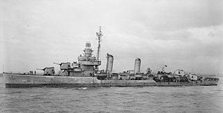
USS Knight (DD-633), a Gleaves-class destroyer, is the only ship of the United States Navy to be named for Admiral Austin M. Knight.

Marine Medium Tilt Rotor Squadron 165 (VMM-165) is a United States Marine Corps Tilt-rotor squadron consisting of MV-22B Osprey transport aircraft. The squadron, known as the "White Knights", is based at Marine Corps Air Station Miramar, California and fall under the command of Marine Aircraft Group 16 (MAG-16) and the 3rd Marine Aircraft Wing.

Grimes is a census-designated place in Colusa County, California on the Southern Pacific Railroad. It lies at an elevation of 46 feet. On the outskirts of Grimes there is wildlife such as jackrabbits and coyotes. The two main roads that run through it are State Route 45 and Grimes-Arbuckle Road. Its ZIP code is 95950, and its area code is 530. Grimes's population was 391 at the 2010 census.

Tyndall Landing is an unincorporated community in Yolo County, California. It is located on the Sacramento River 8 miles (13 km) east of Dunnigan, at an elevation of 36 feet.
Fremont Landing was a former settlement in Yolo County, California, United States. It was located on the Sacramento River 5.5 miles (8.9 km) east-southeast of Knights Landing, at an elevation of 26 feet.
Merrills Landing is an unincorporated community in Butte County, California, on the Sacramento River. It lies at an elevation of 177 feet.
Mowry Landing is an unincorporated community in Alameda County, California. It is located 2 miles (3.2 km) southeast of Newark. It lies at an elevation of 10 feet.
Eastham is a former settlement in Yolo County, California. It was located 2.5 miles (4.0 km) north-northwest of Knights Landing on the Southern Pacific Railroad.
Eden Landing is a former settlement in Alameda County, California. Eden Landing was located west-southwest of Mount Eden. Its site is now located within the corporate limits of Hayward. Eden Landing was established in 1854 by farmers who were dissatisfied with the freight charges at Allen's Landing, which was a quarter of a mile west. The place was bought by Richard Barron in 1855, and renamed Barrons Landing. Henry Louis Petermann and Mary F. Petermann operated their salt works here. Stokes Landing was located east of Eden Landing on Alameda Creek.

Fields Landing is a census-designated place in Humboldt County, California. It is located on Humboldt Bay 6 miles (9.7 km) south-southwest of downtown Eureka, at an elevation of 13 feet. The ZIP Code is 95537. The population was 276 at the 2010 census.
Paymaster Landing is an unincorporated community in Imperial County, California. It is located on the Colorado River 13 miles (21 km) south of Palo Verde, at an elevation of 213 feet.
Sacramento Landing is an unincorporated community in Marin County, California. It is located on the southwest shore of Tomales Bay 6.5 miles (10 km) south of Tomales, at an elevation of 23 feet.
Vincent Landing is an unincorporated community in Marin County, California. It is located on the northeast shore of Tomales Bay 2.5 miles (4 km) southwest of Tomales, at an elevation of 20 feet.
Fish Rock is an unincorporated community in Mendocino County, California. It is located 4 miles (6.4 km) northwest of Gualala, at an elevation of 171 feet.
Union Landing is an unincorporated community in Mendocino County, California. It is located on California State Route 1 near the Pacific Ocean 4.25 miles (6.8 km) north of Westport, at an elevation of 102 feet.
Moss is an unincorporated community in Monterey County, California. It is located near Moss Landing, at an elevation of 3 feet.
Ratto Landing is an unincorporated community in Napa County, California. It lies at an elevation of 3 feet. Ratto Landing is located on the Napa River, 3.5 miles (5.6 km) northwest of Napa Junction.


