The Louisiana Purchase was the acquisition of the territory of Louisiana by the United States from the French First Republic in 1803. This consisted of most of the land in the Mississippi River's drainage basin west of the river. In return for fifteen million dollars, or approximately eighteen dollars per square mile, the United States nominally acquired a total of 828,000 sq mi in Middle America. However, France only controlled a small fraction of this area, most of which was inhabited by Native Americans; effectively, for the majority of the area, the United States bought the preemptive right to obtain Indian lands by treaty or by conquest, to the exclusion of other colonial powers.

North America is a continent in the Northern and Western Hemispheres. North America is bordered to the north by the Arctic Ocean, to the east by the Atlantic Ocean, to the southeast by South America and the Caribbean Sea, and to the west and south by the Pacific Ocean. The region includes the Bahamas, Bermuda, Canada, the Caribbean, Central America, Clipperton Island, Greenland, Mexico, Saint Pierre and Miquelon, Turks and Caicos Islands, and the United States.

The Rocky Mountains, also known as the Rockies, are a major mountain range and the largest mountain system in North America. The Rocky Mountains stretch 3,000 miles in straight-line distance from the northernmost part of western Canada, to New Mexico in the southwestern United States. Depending on differing definitions between Canada and the U.S., its northern terminus is located either in northern British Columbia's Terminal Range south of the Liard River and east of the Trench, or in the northeastern foothills of the Brooks Range/British Mountains that face the Beaufort Sea coasts between the Canning River and the Firth River across the Alaska-Yukon border. Its southernmost point is near the Albuquerque area adjacent to the Rio Grande rift and north of the Sandia–Manzano Mountain Range. Being the easternmost portion of the North American Cordillera, the Rockies are distinct from the tectonically younger Cascade Range and Sierra Nevada, which both lie farther to its west.

The Americas, sometimes collectively called America, are a landmass comprising the totality of North America and South America. The Americas make up most of the land in Earth's Western Hemisphere and comprise the New World.

The term "United States," when used in the geographical sense, refers to the contiguous United States, Alaska, Hawaii, the five insular territories of Puerto Rico, Northern Mariana Islands, U.S. Virgin Islands, Guam, American Samoa, and minor outlying possessions. The United States shares land borders with Canada and Mexico and maritime borders with Russia, Cuba, The Bahamas, and many other countries, mainly in the Caribbeanin addition to Canada and Mexico. The northern border of the United States with Canada is the world's longest bi-national land border.

The Appalachian Mountains, often called the Appalachians, are a mountain range in eastern to northeastern North America. The term "Appalachian" refers to several different regions associated with the mountain range, and its surrounding terrain. The general definition used is one followed by the United States Geological Survey and the Geological Survey of Canada to describe the respective countries' physiographic regions. The U.S. uses the term Appalachian Highlands and Canada uses the term Appalachian Uplands; the Appalachian Mountains are not synonymous with the Appalachian Plateau, which is one of the provinces of the Appalachian Highlands.

The Pyrenean Mountain Dog or Chien de Montagne des Pyrénées is a French breed of livestock guardian dog; in France it is commonly called the Patou. It originates from the eastern or French side of the Pyrenees Mountains that separate France and Spain and is recognised as a separate breed from the Mastín del Pirineo or Pyrenean Mastiff from the Spanish side of the mountains, to which it is closely related.

The St. Francois Mountains in southeast Missouri are a mountain range of Precambrian igneous mountains rising over the Ozark Plateau. This range is one of the oldest exposures of igneous rock in North America. The name of the range is spelled out as Saint Francois Mountains in official GNIS sources, but it is sometimes misspelled in use as St. Francis Mountains to match the anglicized pronunciation of both the range and St. Francois County.

The Green Mountains are a mountain range in the U.S. state of Vermont and are a subrange of the Appalachian Mountains. The range runs primarily south to north and extends approximately 250 miles (400 km) from the border with Massachusetts to the border with Quebec, Canada. The part of the same range that is in Massachusetts and Connecticut is known as The Berkshires or the Berkshire Hills and the Quebec portion is called the Sutton Mountains, or Monts Sutton in French.

A pyramidal peak, sometimes called a glacial horn in extreme cases, is an angular, sharply pointed mountain peak which results from the cirque erosion due to multiple glaciers diverging from a central point. Pyramidal peaks are often examples of nunataks.

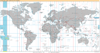
UTC−10:00 is an identifier for a time offset from UTC of −10:00. This time is used in Hawaii, Alaska, French Polynesia, and the Cook Islands.

A show cave—also called tourist cave, public cave, and, in the United States, commercial cave—is a cave which has been made accessible to the public for guided visits.

Pisgah National Forest is a National Forest in the Appalachian Mountains of western North Carolina. It is administered by the United States Forest Service, part of the United States Department of Agriculture. The Pisgah National Forest is completely contained within the state of North Carolina. The forest is managed together with the other three North Carolina National Forests from common headquarters in Asheville, North Carolina. There are local ranger district offices located in Pisgah Forest, Mars Hill, and Nebo.
In art, neorealism refers to a few movements.

The West Indies is a subregion of North America, surrounded by the North Atlantic Ocean and the Caribbean Sea, which comprises 13 independent island countries and 19 dependencies in three archipelagos: the Greater Antilles, the Lesser Antilles, and the Lucayan Archipelago.

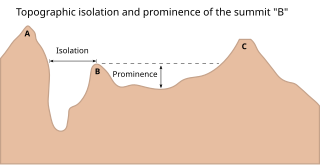
The topographic isolation of a summit is the minimum distance to a point of equal elevation, representing a radius of dominance in which the peak is the highest point. It can be calculated for small hills and islands as well as for major mountain peaks and can even be calculated for submarine summits. Mount Everest, the highest point on Earth, has an undefined isolation, since there are no higher points to reference.

Esther Mountain is a mountain located in Essex County, New York. The mountain is the northernmost of the High Peaks of the Adirondack Mountains and its 28th highest peak. It was the only High Peak named for a woman until 2014, having been named in honor of Esther McComb, who made the first recorded climb to the summit in 1839, at age 15; at the time she was attempting to climb Whiteface Mountain from the north.

Treasure Mountain, elevation 13,535 ft (4,125 m), is a summit in the Elk Mountains of western Colorado. The mountain is in the Raggeds Wilderness southeast of Marble. The massif has been the site of marble mining and a legend of lost French gold.

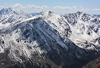
French Mountain is a high mountain summit in the Sawatch Range of the Rocky Mountains of North America. The 13,966-foot (4,257 m) thirteener is located on the Elbert Massif in San Isabel National Forest, 13.0 miles (20.9 km) southwest by west of the City of Leadville in Lake County, Colorado, United States.


