Related Research Articles

Geodesy or geodetics is the science of measuring and representing the geometry, gravity, and spatial orientation of the Earth in temporally varying 3D. It is called planetary geodesy when studying other astronomical bodies, such as planets or circumplanetary systems. Geodesy is an earth science and many consider the study of Earth's shape and gravity to be central to that science. It is also a discipline of applied mathematics.

In geography, latitude is a coordinate that specifies the north–south position of a point on the surface of the Earth or another celestial body. Latitude is given as an angle that ranges from −90° at the south pole to 90° at the north pole, with 0° at the Equator. Lines of constant latitude, or parallels, run east–west as circles parallel to the equator. Latitude and longitude are used together as a coordinate pair to specify a location on the surface of the Earth.

A geographic coordinate system (GCS) is a spherical or geodetic coordinate system for measuring and communicating positions directly on Earth as latitude and longitude. It is the simplest, oldest and most widely used of the various spatial reference systems that are in use, and forms the basis for most others. Although latitude and longitude form a coordinate tuple like a cartesian coordinate system, the geographic coordinate system is not cartesian because the measurements are angles and are not on a planar surface.

A prime meridian is an arbitrarily chosen meridian in a geographic coordinate system at which longitude is defined to be 0°. Together, a prime meridian and its anti-meridian form a great circle. This great circle divides a spheroid, like Earth, into two hemispheres: the Eastern Hemisphere and the Western Hemisphere. For Earth's prime meridian, various conventions have been used or advocated in different regions throughout history. Earth's current international standard prime meridian is the IERS Reference Meridian. It is derived, but differs slightly, from the Greenwich Meridian, the previous standard.

The World Geodetic System (WGS) is a standard used in cartography, geodesy, and satellite navigation including GPS. The current version, WGS 84, defines an Earth-centered, Earth-fixed coordinate system and a geodetic datum, and also describes the associated Earth Gravitational Model (EGM) and World Magnetic Model (WMM). The standard is published and maintained by the United States National Geospatial-Intelligence Agency.

The Greenwich meridian is a prime meridian, a geographical reference line that passes through the Royal Observatory, Greenwich, in London, England. From 1884 to 1974, the Greenwich meridian was the international standard prime meridian, used worldwide for timekeeping and navigation. The modern standard, the IERS Reference Meridian, is based on the Greenwich meridian, but differs slightly from it. This prime meridian was first established by Sir George Airy in 1851, and by 1884, over two-thirds of all ships and tonnage used it as the reference meridian on their charts and maps. In October of that year, at the invitation of the President of the United States, 41 delegates from 25 nations met in Washington, D.C., United States, for the International Meridian Conference. This conference selected the meridian passing through Greenwich as the world standard prime meridian due to its popularity. However, France abstained from the vote, and French maps continued to use the Paris meridian for several decades. In the 18th century, London lexicographer Malachy Postlethwayt published his African maps showing the "Meridian of London" intersecting the Equator a few degrees west of the later meridian and Accra, Ghana.

The National Geodetic Survey (NGS) is a United States federal agency based in Washington, D.C. that defines and manages a national coordinate system, providing the foundation for transportation and communication, mapping and charting, and a large number of science and engineering applications. Since its founding in 1970, it has been part of the National Oceanic and Atmospheric Administration (NOAA), a division within the Department of Commerce.
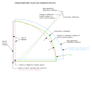
The vertical deflection (VD) or deflection of the vertical (DoV), also known as deflection of the plumb line and astro-geodetic deflection, is a measure of how far the gravity direction at a given point of interest is rotated by local mass anomalies such as nearby mountains. They are widely used in geodesy, for surveying networks and for geophysical purposes.
A geodetic datum or geodetic system is a global datum reference or reference frame for unambiguously representing the position of locations on Earth by means of either geodetic coordinates or geocentric coordinates. Datums are crucial to any technology or technique based on spatial location, including geodesy, navigation, surveying, geographic information systems, remote sensing, and cartography. A horizontal datum is used to measure a horizontal position, across the Earth's surface, in latitude and longitude or another related coordinate system. A vertical datum is used to measure the elevation or depth relative to a standard origin, such as mean sea level (MSL). A three-dimensional datum enables the expression of both horizontal and vertical position components in a unified form. The concept can be generalized for other celestial bodies as in planetary datums.
Geodetic astronomy or astronomical geodesy (astro-geodesy) is the application of astronomical methods into geodetic networks and other technical projects of geodesy.

31 Aquilae is a star in the equatorial constellation of Aquila. 31 Aquilae is its Flamsteed designation though it also bears the Bayer designation b Aquilae. This star has an apparent visual magnitude of 5.16 and is 49.5 light years from Earth. It has no known companions.
The Catalogue of Fundamental Stars is a series of six astrometric catalogues of high precision positional data for a small selection of stars to define a celestial reference frame, which is a standard coordinate system for measuring positions of stars.

The North American Datum (NAD) is the horizontal datum now used to define the geodetic network in North America. A datum is a formal description of the shape of the Earth along with an "anchor" point for the coordinate system. In surveying, cartography, and land-use planning, two North American Datums are in use for making lateral or "horizontal" measurements: the North American Datum of 1927 (NAD 27) and the North American Datum of 1983 (NAD 83). Both are geodetic reference systems based on slightly different assumptions and measurements.

The Earth-centered, Earth-fixed coordinate system, also known as the geocentric coordinate system, is a cartesian spatial reference system that represents locations in the vicinity of the Earth as X, Y, and Z measurements from its center of mass. Its most common use is in tracking the orbits of satellites and in satellite navigation systems for measuring locations on the surface of the Earth, but it is also used in applications such as tracking crustal motion.

The Astronomical Calculation Institute is a research institute in Heidelberg, Germany, dating from the 1700s. Beginning in 2005, the ARI became part of the Center for Astronomy at Heidelberg University. Previously, the institute directly belonged to the state of Baden-Württemberg.
The Bessel ellipsoid is an important reference ellipsoid of geodesy. It is currently used by several countries for their national geodetic surveys, but will be replaced in the next decades by modern ellipsoids of satellite geodesy.
An Earth ellipsoid or Earth spheroid is a mathematical figure approximating the Earth's form, used as a reference frame for computations in geodesy, astronomy, and the geosciences. Various different ellipsoids have been used as approximations.
The IERS Reference Meridian (IRM), also called the International Reference Meridian, is the prime meridian maintained by the International Earth Rotation and Reference Systems Service (IERS). It passes about 5.3 arcseconds east of George Biddell Airy's 1851 transit circle which is 102 metres (335 ft) at the latitude of the Royal Observatory, Greenwich. Thus it differs slightly from the historical Greenwich Meridian.

The Geodetic Observatory Wettzell is located atop the 616 meter-high mountain Wagnerberg, west of the village Wettzell in the German district Cham in the Bavarian Forest.

A planetary coordinate system is a generalization of the geographic, geodetic, and the geocentric coordinate systems for planets other than Earth. Similar coordinate systems are defined for other solid celestial bodies, such as in the selenographic coordinates for the Moon. The coordinate systems for almost all of the solid bodies in the Solar System were established by Merton E. Davies of the Rand Corporation, including Mercury, Venus, Mars, the four Galilean moons of Jupiter, and Triton, the largest moon of Neptune. A planetary datum is a generalization of geodetic datums for other planetary bodies, such as the Mars datum; it requires the specification of physical reference points or surfaces with fixed coordinates, such as a specific crater for the reference meridian or the best-fitting equigeopotential as zero-level surface.
References
- ↑ Gupta, Harsh (ed) (2021) Encyclopedia of Solid Earth Geophysics Springer ISBN 9783030586300 p329
- ↑ NERC Herstmonceux Science and Technology Facilities Council
- ↑ Drewes, Hermann (2009) Geodetic Reference Frames IAG p101
- ↑ Geodetic reference system enables highly accurate positioning Technical University Munich, 2016
- ↑ Goddard Geophysical and Astronomical Observatory NASA
- ↑ Yarragadee: the ‘geodetic supersite’ in the West Australian desert Geoscience Australia, 2023