
The Matterhorn is a mountain of the Alps, straddling the main watershed and border between Switzerland and Italy. It is a large, near-symmetric pyramidal peak in the extended Monte Rosa area of the Pennine Alps, whose summit is 4,478 metres (14,692 ft) high, making it one of the highest summits in the Alps and Europe. The four steep faces, rising above the surrounding glaciers, face the four compass points and are split by the Hörnli, Furggen, Leone/Lion, and Zmutt ridges. The mountain overlooks the Swiss town of Zermatt, in the canton of Valais, to the north-east and the Italian town of Breuil-Cervinia in the Aosta Valley to the south. Just east of the Matterhorn is Theodul Pass, the main passage between the two valleys on its north and south sides, which has been a trade route since the Roman Era.

Zermatt is a municipality in the district of Visp in the German-speaking section of the canton of Valais in Switzerland. It has a year-round population of about 5,800 and is classified as a town by the Swiss Federal Statistical Office (FSO).
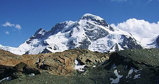
The Breithorn is a mountain range of the Pennine Alps with its highest peak of the same name, located on the border between Switzerland and Italy. It lies on the main chain of the Alps, approximately halfway between the Matterhorn and Monte Rosa and east of the Theodul Pass. Most of the massif is glaciated and includes several subsidiary peaks, all located east of the main summit: the Central Breithorn, the western Breithorn Twin, the Gendarm and the Roccia Nera. The main summit is sometimes distinguished by the name Western Breithorn. The nearest settlements are Zermatt (Valais) and St-Jacques.

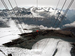
The Klein Matterhorn is a peak of the Pennine Alps, overlooking Zermatt in the Swiss canton of Valais. At 3,883 metres (12,740 ft) above sea level, it is the highest place in Europe that can be reached by aerial tramway or gondola lift, as well as by any other means of transport. The Klein Matterhorn is part of the Breithorn massif and overlooks on its south side the almost equally high flat glacier named Breithorn Plateau, just north of the international border with Italy. The name "Klein Matterhorn" is a reference to its much larger neighbour, the Matterhorn, which lies 7 km (4.3 mi) away across the Theodul Pass.

Monte Rosa is a mountain massif in the eastern part of the Pennine Alps. It is between Italy's and Switzerland's (Valais). Monte Rosa is the second highest mountain in the Alps and western Europe, after Mont Blanc.

The tricable gondola lift, also known as the 3S gondola lift, is a cable car system that was developed by the Swiss company Von Roll transport systems in Thun to unite the benefits of a gondola lift with those of a reversible cable car system. '3S' is an abbreviation of the German word dreiseil, meaning 'tricable'.
Breuil-Cervinia is an alpine resort in the Aosta Valley region of northwest Italy. It is a frazione of the comune of Valtournenche.

The Gornergrat is a rocky ridge of the Pennine Alps, overlooking the Gorner Glacier south-east of Zermatt in Switzerland. It can be reached from Zermatt by the Gornergrat rack railway (GGB), the highest open-air railway in Europe. Between the Gornergrat railway station and the summit is the Kulm Hotel. In the late 1960s two astronomical observatories were installed in the two towers of the Kulmhotel Gornergrat. The project “Stellarium Gornergrat” is hosted in the Gornergrat South Observatory.
The Furgghorn is a mountain of the Pennine Alps, located on the boundary between the canton of Valais (Switzerland) and Aosta Valley. It lies on the range south-east of the Matterhorn, near the Theodul Pass. The closest locality is Breuil-Cervinia on the Italian side. The closest locality on the Swiss side is Zermatt.

Bettmeralp is a municipality in the district of Raron in the canton of Valais in Switzerland. On 1 January 2014 the former municipalities of Betten and Martisberg merged into the municipality of Bettmeralp. Before the merger, Bettmeralp was the name of a village and ski resort in Betten.

The Theodulhorn is a mountain of the Pennine Alps, overlooking the Theodul Pass on the border between Switzerland and Italy. It lies south of Zermatt and east of Breuil-Cervinia. The northern side of the mountain is heavily glaciated and is part of a ski area.

Gobba di Rollin is a mountain of the Pennine Alps, straddling the border between Switzerland and Italy. It is located south of the Breithorn and it is largely covered by ice, the summit area being particularly flat. On the north side is the Breithorn Plateau of the Theodul Glacier, on the east side is the Verraz Glacier and on the south is the Glacier d'Aventine.

Trockener Steg is a minor prominence in the area between the Matterhorn and the Breithorn, south of Zermatt in the canton of Valais. It lies at a height of 2,939 meters (9,642 ft) above sea level, near the front of the Upper Theodul Glacier.

Theodul Pass, elevation 3,295 metres (10,810 ft), is a high mountain pass across the eastern Pennine Alps, connecting Zermatt in the Swiss canton of Valais and Breuil-Cervinia in the Italian region of Aosta Valley. Theodul Pass is the lowest and the easiest pass between the valleys of Zermatt and Valtournanche.
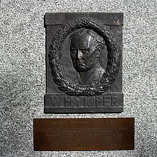
The first ascent of the Matterhorn was a mountaineering expedition made by Edward Whymper, Lord Francis Douglas, Charles Hudson, Douglas Hadow, Michel Croz, and two Zermatt guides, Peter Taugwalder and his son of the same name, on 14 July 1865. Douglas, Hudson, Hadow and Croz were killed on the descent when Hadow slipped and pulled the other three with him down the north face. Whymper and the Taugwalder guides, who survived, were later accused of having cut the rope below to ensure that they were not dragged down with the others, but the subsequent inquiry found no evidence of this and they were acquitted.

Refuge Jean-Antoine Carrel is a refuge in the Alps at an altitude of 3,830m in Aosta Valley, Italy. It is located on the south-west ridge of the Matterhorn, near the Swiss border.
Testa Grigia is a rocky prominence above the Theodul Pass, located on the border between Italy and Switzerland (Valais). It overlooks the Plateau Rosa section of the Theodul Glacier on its east side.
The Theodul Glacier is a glacier of the Alps, located south of Zermatt in the canton of Valais. It lies on the Swiss side of the Pennine Alps, although its upper basin touches the Italian region of the Aosta Valley. The glacier descends from the west side of the Breithorn and splits into two diverging branches above Gandegg: the Upper Theodul Glacier, spilling on a high plateau near Trockener Steg, together with the Furgg Glacier, and the Lower Theodul Glacier, reaching a height of about 2,500 metres (8,202 ft) above the Gorner Glacier. Both branches are part of the Rhone basin, through the rivers Gornera, Mattervispa, and Vispa. Slightly above the glacier splitting is the Theodul Pass, crossing the border between Switzerland and Italy, and connecting Zermatt to Breuil-Cervinia. On the west, the Theodul Glacier is overlooked by the Matterhorn.


