Fès-Boulemane

Last updated • 1 min readFrom Wikipedia, The Free Encyclopedia
Fès-Boulemane
فاس بولمان
Fes-Boulemane in Morocco (de-facto).svg
Location in Morocco
Coordinates: 34°2′N5°0′W / 34.033°N 5.000°W / 34.033; -5.000
CountryFlag of Morocco.svg  Morocco
Capital Fès
Area
  Total19,795 km2 (7,643 sq mi)
Population
 (2014 census)
  Total1,808,295
Time zone UTC+0 (WET)
  Summer (DST) UTC+1 (WEST)
ISO 3166 code MA-05

Fès-Boulemane (Arabic : فاس بولمان) was formerly one of the sixteen regions of Morocco from 1997 to 2015. It was situated in an agricultural region of northern Morocco, and borders Rif Mountains to the north. It covered an area of 19,795 km2 and had a population of 1,808,295 (2014 census). [1] The capital was Fès. In 2015, it expanded Taounate and Taza Provinces (formerly from the Taza-Al Hoceima-Taounate Region); and Meknès Prefecture and El Hajeb and Ifrane Provinces (formerly from the Meknès-Tafilalet Region) to form the Region of Fès-Meknès.

Contents

Administrative divisions

The region was made up of the following provinces and prefectures :

Subdivisions

flagprovince / prefecturecommunitiessurface area
(Km2)
post codepopulation
(2 September 2004)
population
(2 September 2014)
Flag of Boulmane Province.png Boulemane Province (MA-BES)14395 Km 233XXX185.110 ???
White flag with question mark.png Boulemane 330036.910 ???
White flag with question mark.png Imouzzer Marmoucha 331524.001???
White flag with question mark.png Missour (capital of the province)3325220.978???
White flag with question mark.png Outat El Haj 3330413.945???
White flag with question mark.png Ait Bazza 331723.480???
White flag with question mark.png Ait El Mane 331732.243???
White flag with question mark.png Almis Marmoucha 331742.698???
White flag with question mark.png El Mers 331025.891???
White flag with question mark.png Enjil, Morocco 330028.164???
White flag with question mark.png Guigou, Morocco (Almis Guigou)3305319.035???
White flag with question mark.png Serghina ؟؟؟؟؟3.726???
White flag with question mark.png Skoura M'Daz 333528.713???
White flag with question mark.png Talzemt 331763.710???
White flag with question mark.png Ksabi Moulouya 3320210.067???
White flag with question mark.png Ouizeght 332735.509???
White flag with question mark.png Sidi Boutayeb ؟؟؟؟؟9.522???
White flag with question mark.png El Orjane 333247.609???
White flag with question mark.png Ermila ؟؟؟؟؟6.774???
White flag with question mark.png Fritissa 3332226.022???
White flag with question mark.png Oulad Ali Youssef 333026.669???
White flag with question mark.png Tissaf 333239.444???
White flag with question mark.png Prefecture of Fez (MA-FES)312 Km 230XXX977.946 ???
White flag with question mark.png Fes-Agdal (Arrondissement)30000144.064???
White flag with question mark.png Fes-Medina (Arrondissement)3020291.473???
White flag with question mark.png Jnan El Ouard (Arrondissement)30120174.226???
White flag with question mark.png Zouagha (Arrondissement)30020, 30043163.291???
White flag with question mark.png El Mariniyine (Arrondissement)30024191.093???
White flag with question mark.png Saiss (Arrondissement)30022156.590???
White flag with question mark.png Mechouar Fes Jdid (Arrondissement)3000526.078???
White flag with question mark.png Oulad Tayeb 3002319.144???
White flag with question mark.png Ain Bida ؟؟؟؟؟6.854???
White flag with question mark.png Sidi Harazem 302055.133???
White flag with question mark.png Skhinate ؟؟؟؟؟3.317???
Flag of Sefrou Province.png Sefrou Province (MA-SEF)31XXX259.577 ???
White flag with question mark.png Bhalil 3110011.638???
White flag with question mark.png Ribate El Kheir (Ahermoumou prev.)3135012.654???
White flag with question mark.png El Menzel 3120011.484???
White flag with question mark.png Adrej 310032.236???
White flag with question mark.png Ain Timguenai ؟؟؟؟؟5.778???
White flag with question mark.png Bir Tam Tam 311529.714???
White flag with question mark.png Dar El Hamra 310264.022???
White flag with question mark.png Ighzrane 3137211.050???
White flag with question mark.png Mtarnagha 312225.284???
White flag with question mark.png Oulad Mkoudou 312027.821???
White flag with question mark.png Ras Tabouda 313026.516???
White flag with question mark.png Tafajight 310322.047???
White flag with question mark.png Imouzzer Kandar 3125013.745???
White flag with question mark.png Ain Cheggag 3105215.475???
White flag with question mark.png Ait Sebaa Lajrouf 3127217.400???
White flag with question mark.png Sefrou (Capital of the province)3100064.006???
White flag with question mark.png Aghbalou Aqorar 3102315.835???
White flag with question mark.png Ahl Sidi Lahcen 310255.290???
White flag with question mark.png Azzaba 310022.493???
White flag with question mark.png Kandar Sidi Khiar ؟؟؟؟؟8.709???
White flag with question mark.png Laanoussar ؟؟؟؟؟9.343???
White flag with question mark.png Sidi Youssef Ben Ahmed 3102411.292???
White flag with question mark.png Tazouta 310045.745???
White flag with question mark.png Moulay Yacoub Province (MA-MOU)36XXX150.422???
White flag with question mark.png Moulay Yacoub 361503.153???
White flag with question mark.png Ain Chkef 3612236.368???
White flag with question mark.png Mikkes 361256.773???
White flag with question mark.png Sebaa Rouadi 3610420.695???
White flag with question mark.png Sebt Loudaya ؟؟؟؟؟12.232???
White flag with question mark.png Ain Bou Ali ؟؟؟؟؟12.269???
White flag with question mark.png Ain Kansra 3622211.534???
White flag with question mark.png Laajajra 3612413.931???
White flag with question mark.png Louadaine ؟؟؟؟؟11.283???
White flag with question mark.png Oulad Mimoun 361269.393???
White flag with question mark.png Sidi Daoud, Morocco 3617212.791???

Related Research Articles

<span class="mw-page-title-main">Tangier-Tetouan</span> Region in Morocco

Tangier-Tétouan was formerly one of the sixteen regions of Morocco from 1997 to 2015. It covered an area of 11,570 km2 and had a population of 3,157,075. The capital was Tangier. In 2015, Al Hoceïma Province from Taza-Al Hoceima-Taounate was added to it to form the region of Tanger-Tétouan-Al Hoceïma.

<span class="mw-page-title-main">Meknès-Tafilalet</span> Region in Morocco

Meknès-Tafilalt was one of the sixteen former regions of Morocco that existed from 1997 to 2015. It was situated in north-central Morocco, bordering Algeria. It covered an area of 79,210 km² and record a population of 2,316,865 in the 2014 census. The capital was Meknes.

<span class="mw-page-title-main">Taza-Al Hoceima-Taounate</span> Region in Morocco

Taza-Al Hoceima-Taounate was formerly one of the sixteen regions of Morocco from 1997 to 2015. It was situated in northern Morocco. It covered an area of 24,155 km² and had a population of 1,807,036. The capital was Al Hoceima.

<span class="mw-page-title-main">Prefectures and provinces of Morocco</span>

In Morocco, the 75 second-level administrative subdivisions are 13 prefectures and 62 provinces. They are subdivisions of the 12 regions of Morocco. Each prefecture or province is subdivided into arrondissements, municipalities or urban municipalities in other urban areas, and districts in rural areas. The districts are subdivided into rural municipalities. One prefecture (Casablanca) is also subdivided into préfectures d'arrondissements, similar to districts (cercles) except they are grouping a few arrondissements instead of rural municipalities.

Taounate is a province in the Fès-Meknès region. It is situated in northern Morocco, north-east of Fes. It had a population of 668,232 in the 2004 Census.

<span class="mw-page-title-main">Boulemane Province</span> Province of Morocco

Boulemane Province is a province of Morocco, formerly in the Fès-Boulemane Region. The Fès-Boulemane region became part of Fès-Meknès September 2015 by merging Fès-Boulemane with the prefecture of Meknès and the provinces of El Hajeb and Ifrane and the provinces of Taounate and Taza.

<span class="mw-page-title-main">Taza Province</span>

Taza is a province in the Moroccan region of Fès-Meknès. Its population at the 2014 Census was 516,889.

Ras el Oued is a commune in Taounate Province of the Taza-Al Hoceima-Taounate administrative region, Fès-Meknès, Morocco. At the time of the 2004 census, the commune had a total population of 15949 people living in 2438 households.

<span class="mw-page-title-main">Ait Bazza</span> Rural commune and town in Fès-Meknès, Morocco

Ait Bazza is a small town and rural commune in Boulemane Province of the Fès-Meknès region of Morocco. At the time of the 2004 census, the commune had a total population of 3480 people living in 612 households.

Almis Marmoucha is a small town and rural commune in Boulemane Province of the Fès-Meknès region of Morocco. At the time of the 2004 census, the commune had a total population of 2698 people living in 445 households.

El Mers is a small town and rural commune in Boulemane Province of the Fès-Meknès region of Morocco. At the time of the 2004 census, the commune had a total population of 5,891 people living in 1,178 households.

Tissaf

Enjil is a small town and rural commune in Boulemane Province of the Fès-Meknès region of Morocco. At the time of the 2004 census, the commune had a total population of 8164 people living in 1534 households.

<span class="mw-page-title-main">Ksabi Moulouya</span> Rural commune and town in Fès-Meknès, Morocco

Ksabi Moulouya is a small town and rural commune in Boulemane Province of the Fès-Meknès region of Morocco. At the time of the 2004 census, the commune had a total population of 10067 people living in 1759 households.

El Orjane is a small town and rural commune in Boulemane Province of the Fès-Meknès region of Morocco. At the time of the 2004 census, the commune had a total population of 7609 people living in 1179 households.

Fritissa is a small town and rural commune in Boulemane Province of the Fès-Meknès region of Morocco. At the time of the 2004 census, the commune had a total population of 26022 people living in 3314 households.

Tissaf is a small town and rural commune in Boulemane Province of the Fès-Meknès region of Morocco. At the time of the 2004 census, the commune had a total population of 9444 people living in 1455 households.

<span class="mw-page-title-main">Fez-Meknes</span> Region of Morocco

Fez-Meknes is among the twelve Regions of Morocco. It has a population of 4,236,892. Its capital is Fez. Its current president is Abdelouhed El Ansari, and its current wali (governor) is Mouaad Jamai.

<span class="mw-page-title-main">Tangier-Tetouan-Al Hoceima</span> Region of Morocco

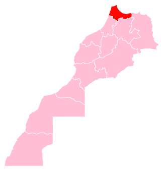
Tangier-Tetouan-Al Hoceima is the northernmost of the twelve regions of Morocco. It covers an area of 15,090 km2 and recorded a population of 3,556,729 in the 2014 Moroccan census. The capital of the region is Tangier.

<span class="mw-page-title-main">Oriental (1997–2015)</span> Region in Morocco

Oriental is one of the sixteen former regions of Morocco. It covers an area of 82,900 km2 and has a population of 1,918,094. The capital and largest city is Oujda, and the second largest city is Nador.

References

  1. "Recensement général de la population et de l'habitat de 2004" (PDF). Haut-commissariat au Plan, Lavieeco.com. Archived from the original (PDF) on 24 July 2012. Retrieved 22 April 2012.