A waypoint is an intermediate point or place on a route or line of travel, a stopping point or point at which course is changed, the first use of the term tracing to 1880. In modern terms, it most often refers to coordinates which specify one's position on the globe at the end of each "leg" (stage) of an air flight or sea passage, the generation and checking of which are generally done computationally.

An automotive navigation system is part of the automobile controls or a third party add-on used to find direction in an automobile. It typically uses a satellite navigation device to get its position data which is then correlated to a position on a road. When directions are needed routing can be calculated. On the fly traffic information can be used to adjust the route.
Since the Global Positioning System (GPS) was introduced in the late 1980s there have been many attempts to integrate it into a navigation-assistance system for blind and visually impaired people.

TomTom N.V. is a Dutch multinational developer and creator of location technology and consumer electronics. Founded in 1991 and headquartered in Amsterdam, TomTom released its first generation of satellite navigation devices to market in 2004. As of 2019 the company has over 4,500 employees worldwide and operations in 29 countries throughout Europe, Asia-Pacific, and the Americas.

A point of interest, or POI, is a specific point location that someone may find useful or interesting. An example is a point on the Earth representing the location of the Eiffel Tower, or a point on Mars representing the location of its highest mountain, Olympus Mons. Most consumers use the term when referring to hotels, campsites, fuel stations or any other categories used in modern automotive navigation systems.

Traffic reporting is the near real-time distribution of information about road conditions such as traffic congestion, detours, and traffic collisions. The reports help drivers anticipate and avoid traffic problems. Traffic reports, especially in cities, may also report on major delays to mass transit that does not necessarily involve roads. In addition to periodic broadcast reports, traffic information can be transmitted to GPS units, smartphones, and personal computers.
GPSBabel is a cross-platform, free software to transfer routes, tracks, and waypoint data to and from consumer GPS units, and to convert between over a hundred types of GPS data formats. It has a command-line interface and a graphical interface for Windows, MacOS, and Linux users.
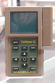
A Satellite navigation device, colloquially called a GPS receiver, or simply a GPS, is a device that is capable of receiving information from GNSS satellites and then to calculate the device's geographical position. Using suitable software, the device may display the position on a map, and it may offer routing directions. The Global Positioning System (GPS) is one of a handful of global navigation satellite systems (GNSS) made up of a network of a minimum of 24, but currently 30, satellites placed into orbit by the U.S. Department of Defense.

Here Technologies is a Netherlands-based company that provides mapping and location data and related services to individuals and companies. It is majority-owned by a consortium of German automotive companies, whilst other companies also own minority stakes. Its roots date back to U.S.-based Navteq in 1985, which was acquired by Finland-based Nokia in 2007. Here is currently based in The Netherlands.

Navit is a free and open-source, modular, touch screen friendly, car navigation system with GPS tracking, realtime routing engine and support for various vector map formats. It features both a 2D and 3D view of map data.
Waze is a GPS navigation software app owned by Google. It works on smartphones and tablet computers that have GPS support. It provides turn-by-turn navigation information and user-submitted travel times and route details, while downloading location-dependent information over a mobile telephone network. Waze describes its app as a community-driven GPS navigation app, which is free to download and use.
GPS Tuner is the name of a software company based in Budapest, Hungary, and of a software product they make. The software is a tool intended for off-road navigation based on the Global Positioning System (GPS), where it is used to determine position while cycling, hiking, geocaching, boating, flying, driving, and many other outdoor sporting activities. It can be used by those with a GPS receiver alone, or in a smartphone, Pocket PC, or iPhone. Recently, the firm released a new version of its navigation software dedicated to electric bicycles named eBike Navigation. This new version includes a variety of battery management features like display for battery capacity, range, gear, power and battery consumption. EBike Navigation also offers assistance recommendations for optimizing battery capacity along with a real rage calculation based on terrain elevation and other variable conditions. In mid-2010, the firm released an iPhone app version of the software that included technology allowing off-road turn-by-turn navigation.
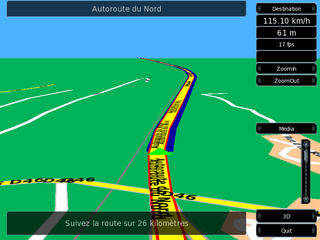
Turn-by-turn Navigation is a feature of some GPS navigation devices where directions for a selected route are continually presented to the user in the form of spoken or visual instructions. The system keeps the user up-to-date about the best route to the destination, and is often updated according to changing factors such as traffic and road conditions. Turn-by-turn systems typically use an electronic voice to inform the user whether to turn left or right, the street name, and how much distance to the turn.
Telenav, Inc. is a wireless location-based services corporation that provides services including Global Positioning System (GPS) satellite navigation, local search, automotive navigation solutions, mobile advertising, enterprise mobility and workflow automation. The company’s headquarters are located in Santa Clara, California in the United States with additional offices in the U.S., Germany, Japan, Romania, China, and Brazil.
This is a list of notable commercial satellite navigation software for various devices, with a specific focus on mobile phones, tablets, tablet PCs,.
MoNav is a free, car navigation system with GPS tracking, realtime routing engine. It uses data from the OpenStreetMap project. It supports multiple platforms and supports car, foot and bicycle navigation.
This article contains a list with gratis satellite navigation software for a range of devices. Some of the free software mentioned here does not have detailed maps or the ability to follow streets or type in street names. However, in many cases, it is also that which makes the program free, avoid the need of an Internet connection, and make it very lightweight. Very basic programs like this may not be suitable for road navigation in cars, but serve their purpose for navigation while walking or trekking, and for use at sea. To determine the GPS coordinates of a destination, one can use sites such as GPScoordinates.eu and GPS visualizer.
HERE WeGo is a web mapping and navigation service, operated by Here Technologies. Originally developed by Nokia as HERE Maps, the mapping software application was first released for Windows Phone and the World Wide Web in 2013 as a revamped version of Nokia Maps. The Here Maps application was then released for the Android platform on 10 December 2014 and later for iOS on 11 March 2015, and the name was changed to Here WeGo in July 2016. It is also the default maps service provider for the Amazon Fire tablets and smartphone.

Locus Map is a multi-functional Android navigation app adding advanced online and offline GPS capabilities to Android devices. Primarily it is designed and used for leisure time outdoor activities like hiking, biking, geocaching. Besides its leisure time utilization the app is also used by professionals e.g. for collecting geospatial data, by rescue squad teams, aerial reconnaissance teams etc.
Karta GPS is a mobile application developed by Karta Software Technologies Lda a daughter company of NDrive for the Android and iOS operating systems. It is distributed for free and pairs open-source map data from OpenStreetMap alongside curated content from Yelp and Foursquare.