MoNav

Last updated
Openstreetmap Navigation for Mobile
Developer(s) Christian Vetter
Initial release8 June 2010 (2010-06-08) [1]
Stable release
0.3.0 / 23 April 2011;7 years ago (2011-04-23)
Written in C++
Operating system Cross-platform
Platform Windows, Windows Mobile, Linux, Symbian, Maemo
Available inEnglish
Type Satellite navigation
License GNU General Public License, v3
Website code.google.com/p/monav/ (archived)

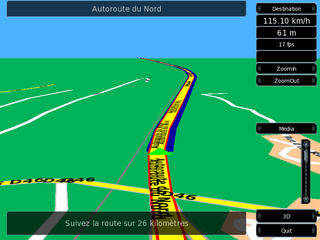
MoNav (short for MObile NAVigation) is a free, car navigation system with GPS tracking, realtime routing engine. It uses data from the OpenStreetMap project. It supports multiple platforms and supports car, foot and bicycle navigation.

Free software software licensed to preserve user freedoms

Free software or libre software is computer software distributed under terms that allow users to run the software for any purpose as well as to study, change, and distribute it and any adapted versions. Free software is a matter of liberty, not price: users—individually or in cooperation with computer programmers—are free to do what they want with their copies of a free software regardless of how much is paid to obtain the program. Computer programs are deemed free insofar as they give users ultimate control over the first, thereby allowing them to control what their devices are programmed to do.

A GPS tracking unit is a navigation device normally carried by a moving vehicle or person that uses the Global Positioning System (GPS) to track the device's movements and determine its location. The recorded location data can either be stored within the tracking unit or transmitted to an Internet-connected device using the cellular, radio, or satellite modem embedded in the unit. This allows the location to be displayed against a map backdrop either in real time or when analysing the track later, using GPS tracking software. Data tracking software is available for smartphones with GPS capability.

OpenStreetMap freely editable world map

OpenStreetMap (OSM) is a collaborative project to create a free editable map of the world. Rather than the map itself, the data generated by the project is considered its primary output. The creation and growth of OSM has been motivated by restrictions on use or availability of map information across much of the world, and the advent of inexpensive portable satellite navigation devices. OSM is considered a prominent example of volunteered geographic information.

Contents

The software includes a local navigation daemon and a client. There is also a preprocessor, that converts OpenStreetMap data to data usable by the daemon, but the preprocessor does not need to run on the navigation unit. It is written in C++ using the Qt toolkit (for the non-graphical parts as well). It is maintained as a project in Google Code using the Mercurial version control system.

Daemon (computing) computer program that runs as a background process

In multitasking computer operating systems, a daemon is a computer program that runs as a background process, rather than being under the direct control of an interactive user. Traditionally, the process names of a daemon end with the letter d, for clarification that the process is in fact a daemon, and for differentiation between a daemon and a normal computer program. For example, syslogd is the daemon that implements the system logging facility, and sshd is a daemon that serves incoming SSH connections.

C++ general purpose high-level programming language

C++ is a general-purpose programming language that was developed by Bjarne Stroustrup as an extension of the C language, or "C with Classes". It has imperative, object-oriented and generic programming features, while also providing facilities for low-level memory manipulation. It is almost always implemented as a compiled language, and many vendors provide C++ compilers, including the Free Software Foundation, Microsoft, Intel, and IBM, so it is available on many platforms.

Qt (software) Object-oriented framework for GUI creation

Qt is a free and open-source widget toolkit for creating graphical user interfaces as well as cross-platform applications that run on various software and hardware platforms such as Linux, Windows, macOS, Android or embedded systems with little or no change in the underlying codebase while still being a native application with native capabilities and speed. Qt is currently being developed by The Qt Company, a publicly listed company, and the Qt Project under open-source governance, involving individual developers and organizations working to advance Qt. Qt is available under both commercial licenses and open source GPL 2.0, GPL 3.0, and LGPL 3.0 licenses.

See also

Related Research Articles

Automotive navigation system satellite navigation system designed for use in automobiles

An automotive navigation system is part of the automobile controls or a third party add-on used to find direction in an automobile. It typically uses a satellite navigation device to get its position data which is then correlated to a position on a road. When directions are needed routing can be calculated. On the fly traffic information can be used to adjust the route.

GpsDrive software

GpsDrive is a computer program designed to act as a vehicle navigation system. The program displays its user's position, obtained from an NMEA-capable GPS receiver, on a zoomable map drawn on a computer screen. The map file is automatically selected depending on the position and preferred scale.

Since the Global Positioning System (GPS) was introduced in the late 1980s there have been many attempts to integrate it into a navigation-assistance system for blind and visually impaired people.

TomTom Dutch manufacturer of automotive navigation systems

TomTom N.V. is a Dutch company that produces traffic, navigation and mapping products. It also makes action cameras, GPS sport watches, fleet management systems, and location-based products. Founded in 1991 and headquartered in Amsterdam, TomTom was originally named Palmtop Software, founded by Peter-Frans Pauwels, Pieter Geelen, Harold Goddijn and Corinne Vigreux. As of 2015 the company has 4,600 employees worldwide and sells products in over 50 countries. TomTom has 56 offices in 37 countries.

gpsd is a daemon that receives data from a GPS receiver, and provides the data back to multiple applications such as Kismet or GPS navigation software. It thus provides a unified interface to receivers of different types, and allows concurrent access by multiple applications.

GPS navigation software usually falls into one of the following two categories:

  1. Navigation with route calculation and directions from the software to the user of the route to take, based on a vector-based map, normally for motorised vehicles with some motorised forms added on as an afterthought.
  2. Navigation tracking, often with a map "picture" in the background, but showing where you have been, and allowing "routes" to be preprogrammed, giving a line you can follow on the screen. This type can also be used for geocaching.
GPS navigation device device that determines its position by analyzing satellite signals

A GPS navigation device, GPS receiver, or simply GPS is a device that is capable of receiving information from GPS satellites and then to calculate the device's geographical position. Using suitable software, the device may display the position on a map, and it may offer directions. The Global Positioning System (GPS) is a global navigation satellite system (GNSS) made up of a network of a minimum of 24, but currently 30, satellites placed into orbit by the U.S. Department of Defense.

Digital mapping is the process by which a collection of data is compiled and formatted into a virtual image. The primary function of this technology is to produce maps that give accurate representations of a particular area, detailing major road arteries and other points of interest. The technology also allows the calculation of distances from one place to another.

Navit

Navit is a free and open-source, modular, touch screen friendly, car navigation system with GPS tracking, realtime routing engine and support for various vector map formats. It features both a 2D and 3D view of map data.

Waze is a GPS navigation software app owned by Google. It works on smartphones and tablet computers that have GPS support. It provides turn-by-turn navigation information and user-submitted travel times and route details, while downloading location-dependent information over a mobile telephone network. Waze describes its app as a community-driven GPS navigation app, which is free to download and use.

TeleType Co.

TeleType Co., Inc. is a privately held company in the United States, specialized in developing software for GPS devices. It was founded in 1981, under the name TeleTypesetting Company and it is based in Boston, Massachusetts. The company's product line includes automotive and commercial GPS navigation systems and other products including GPS receivers and tracking units. It develops and sells the WorldNav software for PC and Windows CE, tools for converting third party maps into WorldNav maps, an SDK and an API that allow the customization of the WorldNav application. TeleType Co. also offers consultancy services for those interested in acquiring and adapting the source code of their software products.

Turn-by-turn navigation GPS feature

Turn-by-turn Navigation is a feature of some GPS navigation devices where directions for a selected route are continually presented to the user in the form of spoken or visual instructions. The system keeps the user up-to-date about the best route to the destination, and is often updated according to changing factors such as traffic and road conditions. Turn-by-turn systems typically use an electronic voice to inform the user whether to turn left or right, the street name, and how much distance to the turn.

Telenav, Inc. is a wireless location-based services corporation that provides services including Global Positioning System (GPS) satellite navigation, local search, automotive navigation solutions, mobile advertising, enterprise mobility and workflow automation. The company’s headquarters are located in Santa Clara, California in the United States with additional offices in the U.S., Germany, Japan, Romania, China, and Brazil.

A software GNSS receiver is a GNSS receiver that has been designed and implemented following the philosophy of Software-defined radio.

Open Source Routing Machine

The Open Source Routing Machine or OSRM is a C++ implementation of a high-performance routing engine for shortest paths in road networks. Licensed under the permissive 2-clause BSD license, OSRM is a free network service. OSRM supports Linux, FreeBSD, Windows, and Mac OS X platform.

OsmAnd offline maps & navigation app

OsmAnd is a map and navigation app for Android and iOS. It uses the OpenStreetMap (OSM) map database for its primary displays, but is an independent app not endorsed by the OpenStreetMap Foundation. It is available in both free and paid versions; the latter unlocks the download limit for offline maps and provides access to Wikipedia points of interest (POIs) and their descriptions from within the app.

NNG (company) company which provides navigation solution software

NNG, formerly known as Nav N Go is a company which provides navigation solution software for the automotive, enterprise, wireless and personal navigation industries. In 2016, NNG had nearly 1000 employees, 12 offices and 4 auxiliary offices on 6 continents. NNG's products are based on the iGO Navigation Engine, which consists of the navigation software, user interfaces, and related content and services, which it sells to device manufacturers, auto makers, network operators, and transport specialist companies.

This article contains a list with gratis satellite navigation software for a range of devices. Some of the free software mentioned here does not have detailed maps or the ability to follow streets or type in street names. However, in many cases, it is also that which makes the program free, avoid the need of an Internet connection, and make it very lightweight. Very basic programs like this may not be suitable for road navigation in cars, but serve their purpose for navigation while walking or trekking, and for use at sea. To determine the GPS coordinates of a destination, one can use sites such as GPScoordinates.eu and GPS visualizer.

Locus Map

Locus Map is a multi-functional Android navigation app adding advanced online and offline GPS capabilities to Android devices. Primarily it is designed and used for leisure time outdoor activities like hiking, biking, geocaching. Besides its leisure time utilization the app is also used by professionals e.g. for collecting geospatial data, by rescue squad teams, aerial reconnaissance teams etc.

iD (software) user-friendly OpenStreetMap editor

iD is a free software online editor for OpenStreetMap (OSM) geodata created in JavaScript and released in 2013. It is designed to be simple and user friendly and is used as a default editor on main OSM page.

References

  1. Initial version control commit

Forks