Gage Park, Brampton

Last updated
Gage Park
GAGE PARK FALL BEAUTY OCT 09.jpg
Gage Park in October 2009
Gage Park, Brampton
Type Urban park
Location Brampton, Ontario
Coordinates 43°41′00″N79°45′28″W / 43.6833°N 79.7578°W / 43.6833; -79.7578
Created1903 (1903)
Operated byCity of Brampton
OpenOpen all year
ParkingNearby street parking, and parking garage beneath City Hall

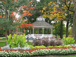
Gage Park is an urban park in Brampton, Ontario, Canada. It is Brampton's oldest municipal park, [1] originally opened in 1903. [2] The park offers floral gardens, a gazebo, large trees, a fountain, trails for rollerblading and jogging, a children's play area, a wading pool, and summer evening concerts. Ice skating on the temperature-controlled skating trail is a popular wintertime activity. [1] [3] [4]

Contents

Gage Park Entrance in Summer, 2021 Gage Park Entrance 2021.jpg
Gage Park Entrance in Summer, 2021
Brampton Rotary Club's Rib'nRoll 2010 RibNRoll2010.jpg
Brampton Rotary Club's Rib'nRoll 2010

History

For many years, Brampton survived without a public park. Public celebrations and large gatherings were either held at the Fair Grounds on Elliott Street or on the Athletic Grounds at Rosalea Park, but both were considered by residents to be far from the centre of town and lacked the shade of trees.[ citation needed ]

In 1902, Sir William J. Gage (owner of Gage Publishing, a publishing house specializing in school text books) purchased a 3.25 acres (1.3 hectares) part of the gardens and lawns of the Alder Lea estate (now called Alderlea) that had been built on Main Street by Kenneth Chisolm in 1867 to 1870. (Chisholm, a merchant and founding father of Brampton, had been the Town reeve, then warden of Peel County, then MPP for Brampton and eventually, Registrar of Peel County.) [5] Sir William donated 1.7 acres (0.7 hectares) of the property to the town, with a specific condition that it be made into a park. Citizens donated $1,054 and the town used the funds to purchase extra land to ensure a larger park. [6] [7]

The Alderlea mansion, part of the original Alderlea Estate, whose Main Street frontage property became part of Gage Park. Alder Lee, Gage Park, Brampton.jpg
The Alderlea mansion, part of the original Alderlea Estate, whose Main Street frontage property became part of Gage Park.

A park committee was appointed, consisting of members of the town council. Many trees were removed, gravelled walkways were prepared, all underbrush was removed and the land was levelled and seeded. W.J. Gage opened the park, the first municipal park in Brampton, on Dominion Day (Canada Day), 1903. Over the following years, a bandstand was erected and the Horticultural Society volunteered to properly label all the trees for the information of the general public.[ citation needed ]

In 1955, the Kinsmen’s Club of Brampton added a wading pool, and in 1971 Brampton received the Flower Fountain from Benson and Hedges Tobacco Company. The Rotary Club of Brampton’s long-standing support of the park has seen the realization of many projects including swings in 1946, and the skating trail and entranceway with digital signage in the 1990s. [2] [4] [8]

The City of Brampton purchased Alderlea as part of its sesquicentennial and started major renovations and an expansion in 2010. Stairs connect Alderlea to Gage Park. [6]

Location

Gage Park is located immediately south-west of the intersection of Main St. S. and Wellington St. West in the historic downtown of Brampton, south of Brampton's City Hall. Street parking is available nearby, in addition to frequently free underground parking beneath City Hall.

Features

Skating trail

Ice skating on the temperature-controlled skating trail is a popular wintertime activity. Skating is open from 10 a.m. to 10 p.m. Sunday through Thursday, and 10 a.m. to 11 p.m. on Fridays and Saturdays. [9] Skate rental and sharpening services are located at Shoe Clinic nearby. [10]

Veterans monument

The Veteran was carved in 2005 from the trunk of a dying red oak that had stood for over a century. It was created to mark the Year of the Veteran in Canada. Carved by artist Jim Menken, the statue was modelled in the image of Bill Bettridge, a decorated veteran of the Second World War and survivor of Operation Overlord (the D-Day landings in Normandy, France) that led to the end of the war. It stands in silent tribute to the many men and women of Brampton who served – and continue to serve – Canada in wars, conflicts, and peacekeeping missions around the world. [2]

Related Research Articles

<span class="mw-page-title-main">Brampton</span> City in Ontario, Canada

Brampton is a city in the Canadian province of Ontario. It is part of the Greater Toronto Area (GTA) and is a lower-tier municipality within Peel Region. The city has a population of 656,480 as of the 2021 Census, making it the ninth most populous municipality in Canada and the third most populous city in the Greater Golden Horseshoe urban area, behind Toronto and Mississauga.

<span class="mw-page-title-main">Stanley Park</span> Public park in Vancouver, Canada

Stanley Park is a 405-hectare (1,001-acre) public park in British Columbia, Canada, that makes up the northwestern half of Vancouver's Downtown peninsula, surrounded by waters of Burrard Inlet and English Bay. The park borders the neighbourhoods of West End and Coal Harbour to its southeast, and is connected to the North Shore via the Lions Gate Bridge. The historic lighthouse on Brockton Point marks the park's easternmost point. While it is not the largest urban park, Stanley Park is about one-fifth larger than New York City's 340-hectare (840-acre) Central Park and almost half the size of London's 960-hectare (2,360-acre) Richmond Park.

<span class="mw-page-title-main">High Park</span> Urban park in Toronto, Canada

High Park is a municipal park in Toronto, Ontario, Canada. High Park is a mixed recreational and natural park, with sporting facilities, cultural facilities, educational facilities, gardens, playgrounds and a zoo. One-third of the park remains in a natural state, with a rare oak savannah ecology. High Park was opened to the public in 1876 and is based on a bequest of land from John George Howard to the City of Toronto. It spans 161 hectares and is the second-largest municipal park in Toronto, after Centennial Park.

<span class="mw-page-title-main">Nathan Phillips Square</span> Public square in Downtown Toronto

Nathan Phillips Square is an urban plaza in Toronto, Ontario, Canada. It forms the forecourt to Toronto City Hall, or New City Hall, at the intersection of Queen Street West and Bay Street, and is named after Nathan Phillips, mayor of Toronto from 1955 to 1962. The square was designed by the City Hall's architect Viljo Revell and landscape architect Richard Strong. It opened in 1965. The square is the site of concerts, art displays, a weekly farmers' market, the winter festival of lights, and other public events, including demonstrations. During the winter months, the reflecting pool is converted into an ice rink for ice skating. The square attracts an estimated 1.5 million visitors yearly. With an area of 4.85 hectares, it is Canada's largest city square.

<span class="mw-page-title-main">Bramalea, Ontario</span> Suburban district in Peel, Ontario, Canada

Bramalea (Bram-a-lee) is a large suburban district in the City of Brampton, Ontario, Canada. Bramalea was created as an innovative "new town", and developed as a separate community from the city. Located in the former Chinguacousy Township, it was Canada's first satellite community developed by one of the country's largest real estate developers, Bramalea Consolidated Developments.

<span class="mw-page-title-main">Greater Grand Forks Greenway</span>

The Greater Grand Forks Greenway is a huge greenway bordering the Red River and Red Lake River in the twin cities of Grand Forks, North Dakota and East Grand Forks, Minnesota. At 2,200 acres (9 km2), the Greenway is more than twice the size of New York City's Central Park. It has an extensive, 20-mile (32 km) system of bike paths, which are used by bikers, walkers, joggers, and rollerbladers. In 2007, the system was designated as a National Recreation Trail by the National Park Service.

<span class="mw-page-title-main">Springbank Park</span> Park in London, Ontario, Canada

Springbank Park is a 240-hectare (300 acre) park located along a stretch of the Thames River in London, Ontario, Canada. The largest park in London, it contains 30 km (19 mi) of trails and is home to Storybook Gardens, a family attraction open year-round.

<span class="mw-page-title-main">Shoppers World Brampton</span> Shopping mall in Ontario, Canada

Shoppers World Brampton is a shopping mall in Brampton, Ontario, Canada. It is host to over 190 stores, including Canadian Tire, Winners and Staples.

<span class="mw-page-title-main">Assiniboine Park</span> Regional park in Tuxedo (Winnipeg), Canada

Assiniboine Park is a park in Winnipeg, Manitoba, Canada, located along the Assiniboine River.

<span class="mw-page-title-main">Claireville Conservation Area</span>

The Claireville Conservation Area is a suburban conservation area located on the border of Peel Region and Toronto in Ontario, Canada. The major part of the area is located in Brampton. The park is a 343 hectare parcel of conservation land located on the west branch of the Humber River. It is one of the largest tracts of land owned by the Toronto and Region Conservation Authority (TRCA). Claireville contains significant natural and cultural heritage features, and has recreation, tourism, and educational facilities and programs.

Windsor's Department of Parks and Recreation maintains 3,000 acres (12 km2) of green space, 180 parks, 40 miles (64 km) of trails, 22 miles (35 km) of sidewalk, 60 parking lots, vacant lands, natural areas and forest cover within the City of Windsor, as well as the Bike Trails, Bike Lanes, and Bike-Friendly Streets.

<span class="mw-page-title-main">Dufferin Grove Park</span> Public park in Toronto, Ontario, Canada

Dufferin Grove Park is a park in the Dufferin Grove neighbourhood of Toronto, Ontario, Canada. The park is located on the east side of Dufferin Street, south of Bloor Street West. It is located a block south of the Dufferin subway station and across the street from Dufferin Mall. The park extends two city blocks east and is primarily green-space with mixed open space and treed areas.

<span class="mw-page-title-main">History of Brampton</span>

Following is an outline is for the history of Brampton, the fourth largest city in Ontario, Canada. European settlers arrived began to settle the area in the early 19th century, with Brampton being formally incorporated into a village in 1853.

<span class="mw-page-title-main">Henderson Park (Lethbridge)</span>

Henderson Park is a 47 hectare park located in Lethbridge, Alberta, Canada. The park contains many amenities and attractions, including a 24 hectare man-made lake, the largest lake in the city. Several annual events are held in the park.

<span class="mw-page-title-main">Brampton City Hall</span> Municipal building in Canada

Brampton City Hall is home to Brampton City Council and the departments of the city. It is located at the intersection of Wellington Street and Main Street in downtown Brampton.

<span class="mw-page-title-main">Donald M. Gordon Chinguacousy Park</span>

Donald M. Gordon Chinguacousy Park, colloquially known as Chinguacousy Park, is a large 40-hectare (100-acre) park in the Bramalea section of Brampton, Ontario, Canada. It is bounded by Queen Street East on the southeast, Bramalea Road on the northeast, and Central Park Drive on the north and west sides. Terry Fox Stadium (Brampton) in the north of the park, sometimes called Terry Fox Track and Field Stadium, has a track and field oval surrounding an artificial turf field with Canadian Football markings and stands for about 1000 spectators. It is used for various Canadian football and soccer matches as well as track and field competitions.

<span class="mw-page-title-main">Marie Curtis Park</span> Public park in Toronto, Canada

Marie Curtis Park is a public park in Toronto, Ontario, Canada. It is located at the mouth of the Etobicoke Creek on Lake Ontario in the Long Branch neighbourhood. Marie Curtis Park was built after the devastating floods of Hurricane Hazel in 1954 destroyed 56 homes and cottages on the site, leaving 1,868 persons homeless and 81 dead. It is named after Marie Curtis, the reeve of Long Branch at the time of its construction. Long Branch at the time was a separate village; it's now amalgamated into the City of Toronto government.

<span class="mw-page-title-main">Heart Lake Conservation Area</span>

Heart Lake Conservation Park (HLCA) occupies 169 hectares in the Etobicoke Creek watershed, within the City of Brampton, Ontario. It is owned and managed by the Toronto and Region Conservation Authority (TRCA).

<span class="mw-page-title-main">Berczy Park</span> Park in Toronto, Ontario, Canada

Berczy Park is a small park in downtown Toronto, Ontario, Canada. The park is triangular in shape, bounded by Scott Street, Front Street and Wellington Street. The park is bordered at its eastern tip, where Wellington and Front join, by the Gooderham Building, a heritage building that is an example of a "flatiron building". A widely admired mural graces the western facade of the building.

References

  1. 1 2 "City of Brampton - Destination Gardens". Archived from the original on 2010-12-14. Retrieved 2010-12-30.
  2. 1 2 3 "A Walk Through Time - Downtown Heritage Walking Tour".
  3. "Tourism Guide 2011".
  4. 1 2 Facebook group for Gage Park
  5. "Biography – CHISHOLM, KENNETH – Volume XIII (1901-1910) – Dictionary of Canadian Biography".
  6. 1 2 "The History of the Alderlea | Alderlea".
  7. "Alderlea reborn: Brampton's heritage home now available for rent". 26 March 2015.
  8. "Gage Park".
  9. "Parks, Trails and Pathways". www.brampton.ca. Archived from the original on 2013-01-15.
  10. "The Shoe Clinic Plus".