
The Republic of Texas, or simply Texas, was a breakaway state in North America. It existed for close to 10 years, from March 2, 1836 to February 19, 1846. Texas shared borders with Mexico, the Republic of the Rio Grande, and the United States of America. The Republic of Texas had engaged in some complex relations with various nations. The United States was one of the key players that recognized Texas's independence. However, they hesitated to annex the Republic due to domestic affairs with Mexico. European powers had extended their recognition and wanted to engage in trade with Texas. These relations were very significant and shaped Texas's republic. This had led to the annexation by the US which led to the Mexican-American War.

The Sabine River is a 360-mile (580 km) long river in the Southern U.S. states of Texas and Louisiana, From the 32nd parallel north and downstream, it serves as part of the boundary between the two states and empties into Sabine Lake, an estuary of the Gulf of Mexico.

Sabine Parish is a parish located in the U.S. state of Louisiana. As of the 2020 census, the population was 22,155. The parish seat and largest town is Many.

The Fredonian Rebellion or Texan revolt of 1826 was the first attempt by Texans to secede from Mexico. The settlers, led by Empresario Haden Edwards, declared independence from Mexican Texas and created the Republic of Fredonia near Nacogdoches. The short-lived republic encompassed the land the Mexican government had granted to Edwards in 1825 and included areas that had been previously settled. Edwards's actions soon alienated the established residents, and the increasing hostilities between them and settlers recruited by Edwards led Víctor Blanco of the Mexican government to revoke Edwards's contract.
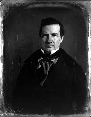
Thomas Jefferson Rusk was an early political and military leader of the Republic of Texas, serving as its first Secretary of War as well as a general at the Battle of San Jacinto. He was later a US politician and served as a Senator from Texas from 1846 until his suicide. He served as the President pro tempore of the United States Senate in 1857.

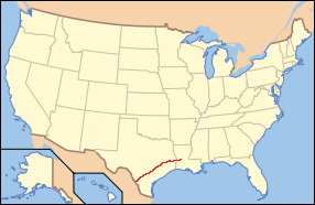
The Old San Antonio Road was a historic roadway located in the U.S. states of Texas and Louisiana. Parts of it were based on traditional Native American trails. Its Texas terminus was about 35 miles (56 km) southeast of Eagle Pass at the Rio Grande in Maverick County, and its northern terminus was at Natchitoches, Louisiana. The road continued from Texas through Monclova to Mexico City.
The Long Expedition was an 1819 attempt to take control of Spanish Texas by filibusters. It was led by James Long and successfully established a small independent government, known as the Republic of Texas. The expedition crumbled later in the year, as Spanish troops drove the invaders out. Long returned to Texas in 1820 and attempted to reestablish his control. In October 1821, Long was defeated by Spanish troops, captured and sent to Mexico City where he was killed by a guard.
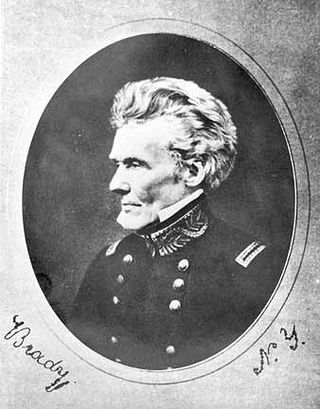
Edmund Pendleton Gaines was a career United States Army officer who served for nearly fifty years, and attained the rank of major general by brevet. He was one of the Army's senior commanders during its formative years in the early to mid-1800s, and was a veteran of the War of 1812, Seminole Wars, Black Hawk War, and Mexican–American War.

Los Adaes was the capital of Tejas (Texas) on the northeastern frontier of New Spain from 1721 to 1773. It included a Franciscan mission, San Miguel de Cuéllar de los Adaes, and a presidio, Nuestra Señora del Pilar de Los Adaes. The name Adaes derives from the indigenous Adai people, members of the Caddoan confederacy of Indians who were the people the missionaries aimed to convert to Christianity. The presidio and mission were established to counter French influence in Louisiana territory and defend New Spain from possible invasion or encroachment by the French. In 1763 Louisiana came under the control of Spain and the Los Adaes outpost was no longer necessary for defense. In 1773 the Spanish closed the mission and presidio and forced the population to move to San Antonio.
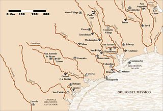
The Runaway Scrape events took place mainly between September 1835 and April 1836 and were the evacuations by Texas residents fleeing the Mexican Army of Operations during the Texas Revolution, from the Battle of the Alamo through the decisive Battle of San Jacinto. The ad interim government of the new Republic of Texas and much of the civilian population fled eastward ahead of the Mexican forces. The conflict arose after Antonio López de Santa Anna abrogated the 1824 Constitution of Mexico and established martial law in Coahuila y Tejas. The Texians resisted and declared their independence. It was Sam Houston's responsibility, as the appointed commander-in-chief of the Provisional Army of Texas, to recruit and train a military force to defend the population against troops led by Santa Anna.

Fort Jesup, also known as Fort Jesup State Historic Site or Fort Jesup or Fort Jesup State Monument, was built in 1822, 22 miles (35 km) west of Natchitoches, Louisiana, to protect the United States border with New Spain and to return order to the Neutral Strip. Originally named Cantonment Jesup, the fort operated from 1822 until 1846. After the abandonment of the fort in 1846, the United States federal government continued to own the abandoned fort site until the privatization of the site in 1869.
The El Camino Real de los Tejas National Historic Trail is a national historic trail covering the U.S. section of El Camino Real de Los Tejas, a thoroughfare from the 18th-century Spanish colonial era in Spanish Texas, instrumental in the settlement, development, and history of Texas. The National Park Service designated El Camino Real de los Tejas National Historic Trail as a unit in the National Trails System in 2004.
The Yowani were a historical group of Choctaw people who lived in Texas. Yowani was also the name of a preremoval Choctaw village.
The Bowl ; John Watts Bowles was one of the leaders of the Chickamauga Cherokee during the Cherokee–American wars, served as a Principal Chief of the Cherokee Nation–West, and was a leader of the Texas Cherokees.
Texas Cherokees were the small settlements of Cherokee people who lived temporarily in what is now Texas, after being forcibly relocated from their homelands, primarily during the time that Spain, and then Mexico, controlled the territory. After the Cherokee War of 1839, the Cherokee communities in Texas were once again forcibly removed to Indian Territory in present-day Oklahoma. When Union troops took control of Cherokee territory in 1863, many "Southern" Cherokees fled to Texas, but after the war, most of them returned to their homes in Indian Territory. Others are part of the multitribal Mount Tabor Indian Community, or Tsalagiyi Nvdagi Tribe which have received commendations for their contributions to the State of Texas.
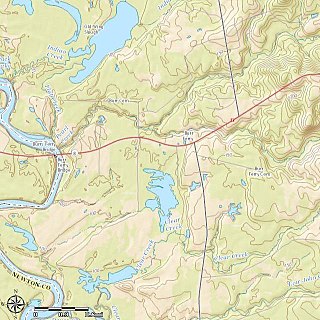
Burr Ferry is an unincorporated community at the junction of LA 8 and LA 111 south, in Vernon Parish, Louisiana, United States. The community is two miles from the site of the old Burr's Ferry on the Sabine River, at the Texas line. The Sabine River, at this location, is the site of two listings on the National Register of Historic Places: Burr's Ferry Bridge and Burr's Ferry Earthworks.

John Marie Durst (1797–1851) was born on the frontier in Arkansas, and was an early American settler, military veteran, and politician in Louisiana and Texas. As a youth, he learned the mercantile trade from his godfather Peter Samuel Davenport in Texas, where he also became fluent in several languages. French, Spanish and various Native American languages were spoken in this region in addition to English, reflecting its different colonial history. At the age of 18, Durst fought in the Battle of New Orleans with a Louisiana militia.

Travis County has had two locations named Montopolis. The first was during the Republic of Texas period north of the Colorado River. The second is today's Montopolis neighborhood in Austin, Texas south of the river. Located southeast of the city's urban core, today's neighborhood is in ZIP code 78741. Montopolis is bounded by Lake Lady Bird on the north, by Grove Street and the Pleasant Valley neighborhood on the west, to the south by Texas State Highway 71, and by U.S. Route 183 on the east. The southeast corner abuts Austin-Bergstrom International Airport. Montopolis is in City Council District 3.

The Gaines–Oliphint House is a historic log cabin in Milam, Sabine County, Texas.
José Domingo Ramón was a Spanish military man and explorer who founded several missions and a presidio in East Texas to prevent French expansion in the area.

