Gallions Reach Crossing

Last updated

Gallions Reach Crossing
Overview
Location River Thames, East London
Coordinates 51°30′33″N0°05′16″E / 51.509283°N 0.087659°E / 51.509283; 0.087659
Start Beckton
End Thamesmead
Operation
Owner Transport for London
CharacterMotor vehicles, railway, cycles, pedestrians
Technical
No. of lanes 4
Route map
Approximate proposed route of the crossing and connecting roads Gallions Reach Ferry map.png
Approximate proposed route of the crossing and connecting roads

The Gallions Reach Crossing was a proposed River Thames crossing close to Gallions Reach in East London, running between Beckton in the London Borough of Newham and Thamesmead in the Royal Borough of Greenwich. Originally a proposed ferry crossing replacing the Woolwich Ferry, later plans suggested either a bridge or a tunnel.

Contents

Plans for both the Gallions Reach Crossing and the Belvedere Crossing downriver were dropped after Sadiq Khan was elected mayor of London in 2016. [1]

History

The crossing was announced as a ferry route by the Mayor of London, Boris Johnson, in 2012 following the cancellation of the Thames Gateway Bridge, with a proposed operation date of 2017. [2] [3] [4] Subsequent reports suggesting a bridge or a tunnel have put the opening date around 2025. [5]

The ferry crossing would have replaced the Woolwich Ferry, with similar operational periods, given that the Woolwich ferry's infrastructure was reaching the end of its serviceable life. Capacity would have been doubled to 300 vehicles per hour in each direction. The promoters claimed that it would alleviate traffic congestion in the Woolwich area, which suffers from a mix of local and cross-ferry traffic. [6]

Alternatives

In addition to the proposed ferry, TfL suggested in 2013 a bridge or a tunnel as an alternative option. This would be a two lane crossing catering for local traffic, and would not be expected to open until after 2021. This would require an additional £30m of capital to service the Woolwich Ferry in the interim period. [7]

In 2015, TfL announced that the bridge or tunnel plans were more likely to go ahead, and invited the public for their views. The crossing would be tolled, and contain two lanes of traffic each way, one dedicated to buses. TfL also suggested the Docklands Light Railway could be extended to Thamesmead or Abbey Wood as part of the works. [5]

In 2023, as part of a consultation into the extension of the Docklands Light Railway to Thamesmead – TfL affirmed that they had no plans to deliver a road bridge in the area, an that they would "explore the removal of the [bridge] safeguarding" as it "conflicts with the vision for new homes, jobs and high-quality town centres". The DLR extension would instead provide a cross-river link in the area. [8]

Advocacy

Approximate location of the crossing's proposed route in the Thames Estuary. Gallions Reach (eastern end), Thames Estuary - geograph.org.uk - 37410.jpg
Approximate location of the crossing's proposed route in the Thames Estuary.

Both Jim Fitzpatrick, MP for Poplar and Limehouse, and Stephen Timms, MP for East Ham, have expressed support for a bridge in this location, rather than a ferry. [9]

See also

Related Research Articles

<span class="mw-page-title-main">Docklands Light Railway</span> Automated light metro system in the Docklands area of London, England

The Docklands Light Railway (DLR) is an automated light metro system primarily serving the redeveloped Docklands area of London and providing a direct connection between London's two major financial districts, Canary Wharf and the City of London. First opened on 31 August 1987, the DLR has been extended multiple times, giving a total route length of 38 km. Lines now reach north to Stratford, south to Lewisham, west to Tower Gateway and Bank in the City of London financial district, and east to Beckton, London City Airport and Woolwich Arsenal. Further extensions are being considered.

<span class="mw-page-title-main">Thamesmead</span> Area of south east London

Thamesmead is an area of south-east London, England, straddling the border between the Royal Borough of Greenwich and the London Borough of Bexley. It is located 11 miles (18 km) east of Charing Cross, north-east of Woolwich and west of Erith. It mainly consists of social housing built from the mid-1960s onwards on former marshland on the south bank of the River Thames.
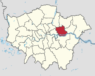
<span class="mw-page-title-main">Woolwich Ferry</span> Ferry across the River Thames in east London

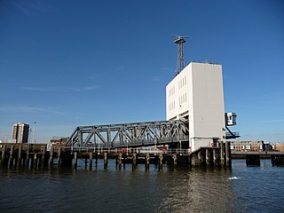
The Woolwich Ferry is a free vehicle and pedestrian ferry across the River Thames in East London, connecting Woolwich on the south bank with North Woolwich on the north. It is licensed and financed by London River Services, the maritime arm of Transport for London (TfL). Around two million passengers use the ferry each year.

<span class="mw-page-title-main">North Woolwich</span> Area of Newham in London, England

North Woolwich is an area in the London Borough of Newham in East London, England, on the northern bank of the River Thames, across the river from Woolwich. It is connected to Woolwich by the Woolwich Ferry and Woolwich foot tunnel.

<span class="mw-page-title-main">Custom House station</span> Railway and DLR station in London

Custom House is a railway station on the Docklands Light Railway (DLR) – on which it is branded Custom House for ExCeL – and on the Elizabeth line, by the Royal Docks, in Custom House in the London Borough of Newham, London, England. It is situated in Travelcard Zone 3. It takes its name from the old Custom House, which formerly stood nearby, and ExCeL London which it serves.

<span class="mw-page-title-main">Royal Docks</span> Area in Newham, London

Royal Docks is an area and a ward in the London Borough of Newham in the London Docklands in East London, England.

<span class="mw-page-title-main">Thames Gateway Bridge</span>

The Thames Gateway Bridge was a proposed crossing over the River Thames in east London, England. It was first mooted in the 1970s but never came to fruition. The concept was re-proposed in 2004, with preliminary planning proceeding until November 2008, when Boris Johnson, the then Mayor of London, formally cancelled the entire £500 million scheme.

<span class="mw-page-title-main">Beckton DLR station</span> Docklands Light Railway station

Beckton is the eastern terminus of the Beckton branch of the Docklands Light Railway (DLR) in the Docklands area of east London. It is in Travelcard Zone 3.

<span class="mw-page-title-main">Beckton</span> Area in East London, England

Beckton is a suburb in east London, England, located 8 miles (12.9 km) east of Charing Cross and part of the London Borough of Newham. Adjacent to the River Thames, the area consisted of unpopulated marshland known as the East Ham Levels in the parishes of Barking, East Ham, West Ham and Woolwich. The development of major industrial infrastructure in the 19th century to support the growing metropolis of London caused an increase in population with housing built in the area for workers of the Beckton Gas Works and Beckton Sewage Treatment Works. The area has a convoluted local government history and has formed part of Greater London since 1965. Between 1981 and 1995 it was within the London Docklands Development Corporation area, which caused the population to increase as new homes were built and the Docklands Light Railway was constructed.

<span class="mw-page-title-main">Gallions Reach DLR station</span> Docklands Light Railway station

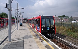
Gallions Reach DLR station is a station on the Docklands Light Railway (DLR) in the Royal Docks area of east London. It serves the recent residential developments around Royal Albert Dock. The station is located on the DLR's Beckton branch, between Cyprus and Beckton stations. It is in Travelcard Zone 3.

<span class="mw-page-title-main">West Silvertown DLR station</span> Docklands Light Railway station

West Silvertown is a Docklands Light Railway (DLR) station in Silvertown, which opened in December 2005. It is located on the Woolwich Arsenal branch. Trains run Westbound to the Bank in the City of London and Eastbound to Woolwich Arsenal, passing through London City Airport station.

<span class="mw-page-title-main">Silvertown Tunnel</span> Tunnel under construction below the Thames between Sivertown and North Greenwich

The Silvertown Tunnel is a road tunnel under construction beneath the River Thames between the Greenwich Peninsula and west Silvertown.

<span class="mw-page-title-main">Gallions Reach</span> Stretch of the Thames outside the East End of London

Gallions Reach is a stretch of the River Thames between Woolwich and Thamesmead. The area is named for the Galyons, a 14th-century family who owned property along this stretch of the river, and places, including street names, on both sides have been named after it.

The Docklands Light Railway extension to Dagenham Dock was a proposed extension of the Docklands Light Railway (DLR) to Dagenham Dock in East London, to serve the Barking Riverside development and the wider London Riverside part of the Thames Gateway.

Thames Wharf is a planned Docklands Light Railway station in the Royal Docks, East London. The station name was previously proposed for another station in the area.

<span class="mw-page-title-main">Gallions Reach Shopping Park</span> Retail park in Beckton, London, England

Gallions Reach Shopping Park is a major out-of-town retail park in Beckton, east London, England. Located on Armada Way beside the River Thames, Gallions Reach is the largest retail park in London and the M25, containing 34 units in an area of 324,000 square feet.

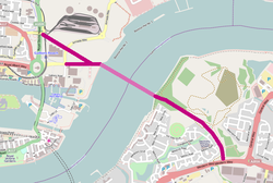
The Docklands Light Railway extension to Thamesmead is a proposed Docklands Light Railway (DLR) extension to serve the Beckton Riverside and Thamesmead redevelopment areas of East London.

The Belvedere Crossing was a proposed River Thames crossing in East and South East London, running between Rainham in the London Borough of Havering and Belvedere in the London Borough of Bexley.

References

  1. Leeming, Lachlan (9 November 2020). "Revive Gallions Reach and Belvedere river crossings, Bexley Council demands". 853. Retrieved 3 May 2023.
  2. "London to get new road tunnel under River Thames within decade, promises Boris Johnson". Daily Telegraph. 12 January 2012. Retrieved 26 June 2013.
  3. "Mayor Boris Johnson announces new Ferry Services between Newham and Greenwich". Newham Recorder. 13 January 2012. Archived from the original on 26 January 2012. Retrieved 26 June 2013.
  4. Andrew Adonis (11 June 2013). "Boris can't put off a new Thames crossing in the east". London Evening Standard . Retrieved 26 June 2013.
  5. 1 2 "Have your say on new river crossings in east and southeast London". Transport for London. December 2015. Retrieved 22 January 2016.
  6. "The Gallions Reach Ferry (a ferry between Thamesmead and Beckton)". Transport for London. 26 June 2013.
  7. Yates, Matthew (March 2013). Thames River Crossings (PDF) (Report). Transport for London. p. 17. Archived from the original (PDF) on 23 August 2013. Retrieved 22 October 2014.
  8. "Extending the Docklands Light Railway to Beckton Riverside and Thamesmead | Have Your Say Transport for London". haveyoursay.tfl.gov.uk. Retrieved 5 February 2024. Although there are now no plans to deliver a road crossing in this location, the land needed to build this bridge remains safeguarded by Government to stop other development taking place that would have prevented the future construction of the bridge. Safeguarding is a planning process which protects land required for infrastructure projects. The safeguarding of this land conflicts with the vision for new homes, jobs and high-quality town centres in these areas, and could limit the transformational opportunity of the proposed DLR extension (which would itself provide a new cross-river link).
  9. "Pressure mounts on Boris over Gallions Reach bridge". The Wharf. 16 May 2013. Archived from the original on 21 October 2014. Retrieved 26 June 2013.