Bhagyanagar a twin city of Koppal, located one kilometre away from Koppal, is a town panchayat area. The city is known for power handloom work, and is a major producer of saris.
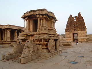
Koppala district, officially known as Koppala district is an administrative district in the state of Karnataka in India. In the past Koppal was referred to as 'Kopana Nagara'. Hampi, a World heritage center, covers some areas of Koppala District. It is situated approximately 38 km away. Anegundi, is also a famous travel destination.
Ankola is a town municipal council and taluka in the Uttara Kannada district of the Indian state of Karnataka. The town is around 33 km (21 mi) from district headquarters Karwar.

Kanakagiri is a town in Karnataka state of India. It was a provincial capital of the Mauryan Empire and later became the capital of the Nayaka dynasty who were the Palegars (feudatory) of the Vijayanagara Empire. It is also the site of the historical site Kanakachalapathi Temple which was built by the Nayakas.

Koppal is the district headquarters of Koppal district in the Indian state of Karnataka. Koppal is surrounded on three sides by hills. It was known as Kopana Nagara. The town has historical landmarks such as the Koppal Fort, Gavimath, and the Male Mallappa Temple. Historically, Koppal was known as Jaina Kashi, meaning the "Kashi" or most-sacred-place for Jains. It was so named because there were more than 700 Basadis, Jain meditation halls or Prarthana Mandirs. Koppal district was carved out of Raichur district, located in the northern part of Karnataka state, on 1 April 1998.

Holenarasipura is a town and taluk in Hassan district of Karnataka. The town is situated on the banks of the Hemavati, one of the tributaries of the Kaveri.
Kampli is a town in the Bellary district, Kampli taluk, in the Indian state of Karnataka. It is a headquarters of Kampli Taluk. The town is situated about 15 km away from Hampi.
Kushtagi is a panchayat town in Koppal district in the Indian state of Karnataka. Kushtagi is a taluk center of Koppal district. This taluk has a population of 353,142 as per the 2021 census estimate. In this taluk, pomegranate fruits are popularly grown.There is a Durga devi temple in heart of the town. To its North lies Ilkal, Gajendragad to the West, Hospet to the South and Sindhanur to the East. Red and black soil can be found in this taluk. A big lake 4kms away from the city is the main source of drinking water is situated in west side and covering the area of more than 300 acres.
Mudalgi also spelled as the Mudalagi is a town and Taluk of Belagavi district in the Karnataka, India.
Mundaragi is a municipal town in Gadag district in the Indian state of Karnataka. Mundargi is close to two district headquarters, being 36 kilometres (22 mi) from Gadag and 50 kilometres (31 mi) from Koppal. It is 99 kilometers from Gajendragad. Mundargi is also the taluka headquarter of the same name. Pin code of Mundaragi is 582118.
Shiggaon is a municipal town in Haveri district in the Indian state of Karnataka.
Tekkalakote, also known as Tekkalakota, is a Panchayat town and Pre-historic Neolithic site in Siruguppa taluk of Ballari district in the Indian state of Karnataka.
Yalaburga also called Yelburga is a panchayat town in Koppal district in the Indian state of Karnataka.
Basavana Bagewadi is a municipality and taluka in Bijapur district in the state of Karnataka, India.
Basapattana is a village in the southern state of Karnataka, India. It is located in the Gangavathi taluk of Koppal district in Karnataka.
Karatagi is a town and taluk headquarters of Karatagi taluk and it is located in Koppal District in Karnataka, India. It is one of the most important commercial centres in the district. The town is made up of multiple paddy fields, which are irrigated by the Tungabhadra Canal. Karatagi is known for its numerous rice mills, which can be found in the town and the surrounding areas.
Navali is a village in the Gangavathi taluk of Koppal district in Karnataka state, India.Navali is famous for Bhogapuresha temple and Bandi Huchamma Devi temple. Navali is 17 km from Karatagi. And near to koti linga temple pura Navali lies on Karatagi-Kanakagiri road and Kalmungi -Gangavati road Which is known as RTP for paddy production of rice
Ginigera is a village in the Koppal taluk of Koppal district in the Indian state of Karnataka. It is 10 kilometres (6.2 mi) from Koppal and lies on National Highway 67. Ginigera is on the railway network and lies on the Guntakal–Hubli line.
Challur is a village in the Karatagi taluk of Koppal district in the southern state of Karnataka, India. Challur is situated near Karatagi.

Sanapur is a village in Gangavathi taluk, Koppal district in Karnataka, India. It has a population of 1628 according to 2011 census. A lake in the village fed by Tungabhadra Dam canal is a tourist attraction. It is 3 km (1.9 mi) away from Virupapur Gaddi and 4 km (2.5 mi) away from Hampi.
