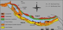
The geology of the Himalayas is a record of the most dramatic and visible creations of the immense mountain range formed by plate tectonic forces and sculpted by weathering and erosion. The Himalayas, which stretch over 2400 km between the Namcha Barwa syntaxis at the eastern end of the mountain range and the Nanga Parbat syntaxis at the western end, are the result of an ongoing orogeny — the collision of the continental crust of two tectonic plates, namely, the Indian Plate thrusting into the Eurasian Plate. The Himalaya-Tibet region supplies fresh water for more than one-fifth of the world population, and accounts for a quarter of the global sedimentary budget. Topographically, the belt has many superlatives: the highest rate of uplift, the highest relief, among the highest erosion rates at 2–12 mm/yr, the source of some of the greatest rivers and the highest concentration of glaciers outside of the polar regions. This last feature earned the Himalaya its name, originating from the Sanskrit for "the abode of the snow".
The Nevadan orogeny occurred along the western margin of North America during the Middle Jurassic to Early Cretaceous time which is approximately from 155 Ma to 145 Ma. Throughout the duration of this orogeny there were at least two different kinds of orogenic processes occurring. During the early stages of orogenesis an "Andean type" continental magmatic arc developed due to subduction of the Farallon oceanic plate beneath the North American Plate. The latter stages of orogenesis, in contrast, saw multiple oceanic arc terranes accreted onto the western margin of North America in a "Cordilleran type" accretionary orogen. Deformation related to the accretion of these volcanic arc terranes is mostly limited to the western regions of the resulting mountain ranges and is absent from the eastern regions. In addition, the deformation experienced in these mountain ranges is mostly due to the Nevadan orogeny and not other external events such as the more recent Sevier and Laramide Orogenies. It is noted that the Klamath Mountains and the Sierra Nevada share similar stratigraphy indicating that they were both formed by the Nevadan orogeny. In comparison with other orogenic events, it appears that the Nevadan Orogeny occurred rather quickly taking only about 10 million years as compared to hundreds of millions of years for other orogenies around the world.

The Grenville orogeny was a long-lived Mesoproterozoic mountain-building event associated with the assembly of the supercontinent Rodinia. Its record is a prominent orogenic belt which spans a significant portion of the North American continent, from Labrador to Mexico, as well as to Scotland.

The Indus-Yarlung suture zone or the Indus-Yarlung Tsangpo suture is a tectonic suture in southern Tibet and across the north margin of the Himalayas which resulted from the collision between the Indian plate and the Eurasian plate starting about 52 Ma. The north side of the suture zone is the Ladakh Batholith of the Karakoram-Lhasa Block. The rocks of the suture zone consist of an ophiolite mélanges composed of Neotethys oceanic crustal flyschs and ophiolites; the Dras Volcanics: which are basalts, dacites and minor radiolarian cherts – the remains of a mid- to late Mesozoic volcanic island arc; and the Indus Molasse which are an Eocene or later continental clastic sediments.

The Sierra Nevada Batholith is a large batholith which forms the core of the Sierra Nevada mountain range in California, exposed at the surface as granite.

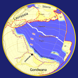
Cimmeria was an ancient continent, or, rather, a string of microcontinents or terranes, that rifted from Gondwana in the Southern Hemisphere and was accreted to Eurasia in the Northern Hemisphere. It consisted of parts of present-day Turkey, Iran, Afghanistan, Pakistan, Tibet, China, Myanmar, Thailand, and Malaysia. Cimmeria rifted from the Gondwanan shores of the Paleo-Tethys Ocean during the Early Permian and as the Neo-Tethys Ocean opened behind it, during the Permian, the Paleo-Tethys closed in front of it. Because the different chunks of Cimmeria drifted northward at different rates, a Meso-Tethys Ocean formed between the different fragments during the Cisuralian. Cimmeria rifted off Gondwana from east to west, from Australia to the eastern Mediterranean. It stretched across several latitudes and spanned a wide range of climatic zones.
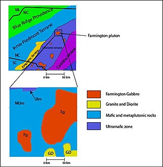
The Carolina Terrane, also called the Carolina Superterrane or Carolinia, is an exotic terrane running ~370 miles (600 km) approximately North-South from central Georgia to central Virginia in the United States. It constitutes a major part of the eastern Piedmont Province.

The Andean orogeny is an ongoing process of orogeny that began in the Early Jurassic and is responsible for the rise of the Andes mountains. The orogeny is driven by a reactivation of a long-lived subduction system along the western margin of South America. On a continental scale the Cretaceous and Oligocene were periods of re-arrangements in the orogeny. The details of the orogeny vary depending on the segment and the geological period considered.

The Bangong suture zone is a key location in the central Tibet conjugate fault zone. Approximately 1,200 km long, the suture trends in an east–west orientation. Located in central Tibet between the Lhasa and Qiangtang terranes, it is a discontinuous belt of ophiolites and mélange that is 10–20 km wide, up to 50 km wide in places. The northern part of the fault zone consists of northeast striking sinistral strike-slip faults while the southern part consists of northwest striking right lateral strike-slip faults. These conjugate faults to the north and south of the Bangong intersect with each other along the Bangong-Nujiang suture zone.

High pressure terranes along the ~1200 km long east-west trending Bangong-Nujiang suture zone (BNS) on the Tibetan Plateau have been extensively mapped and studied. Understanding the geodynamic processes in which these terranes are created is key to understanding the development and subsequent deformation of the BNS and Eurasian deformation as a whole.

The Lhasa terrane is a terrane, or fragment of crustal material, sutured to the Eurasian Plate during the Cretaceous that forms present-day southern Tibet. It takes its name from the city of Lhasa in the Tibet Autonomous Region, China. The northern part may have originated in the East African Orogeny, while the southern part appears to have once been part of Australia. The two parts joined, were later attached to Asia, and then were impacted by the collision of the Indian Plate that formed the Himalayas.
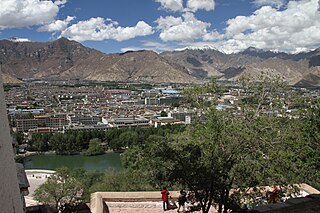
Lhasa is a prefecture-level city, one of the main administrative divisions of the Tibet Autonomous Region of China. It covers an area of 29,274 square kilometres (11,303 sq mi) of rugged and sparsely populated terrain. Its urban center is Lhasa, with around 300,000 residents, which mostly corresponds with the administrative Chengguan District, while its suburbs extend into Doilungdêqên District and Dagzê District. The consolidated prefecture-level city contains additional five, mostly rural, counties.

The Qinling orogenic belt is a tectonic feature that evolved throughout the Proterozoic and Phanerozoic eons due to a variety of tectonic activities. It is a part of the Central China Orogenic Belt, aligned in an east–west orientation across Central China, and spans portions of Shaanxi, Henan and Gansu provinces along the Qinling Mountains which are one of the greatest mountain ranges in China. The first materials involved in the Qinling orogenic belt formed around 2.5 billion years ago, whereas the main morphology of the belt now largely reflects the Triassic collision between the North China Plate and the South China Plate and Cenozoic extension across China. During these 2.5 billion years, various types of rocks have been formed here due to different tectonic processes and chemical reactions between rocks. Therefore, geologists are able to reconstruct the evolution of mountain belt based on evidence preserved in these rocks.

The geology of Peru includes ancient Proterozoic rocks, Paleozoic and Mesozoic volcanic and sedimentary rocks, and numerous basins and the Andes Mountains formed in the Cenozoic.
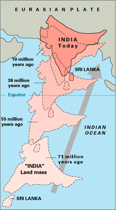
The paleogeography of the India–Asia collision system is the reconstructed geological and geomorphological evolution within the collision zone of the Himalayan orogenic belt. The continental collision between the Indian and Eurasian plate is one of the world's most renowned and most studied convergent systems. However, many mechanisms remain controversial. Some of the highly debated issues include the onset timing of continental collision, the time at which the Tibetan plateau reached its present elevation and how tectonic processes interacted with other geological mechanisms. These mechanisms are crucial for the understanding of Mesozoic and Cenozoic tectonic evolution, paleoclimate and paleontology, such as the interaction between the Himalayas orogenic growth and the Asian monsoon system, as well as the dispersal and speciation of fauna. Various hypotheses have been put forward to explain how the paleogeography of the collision system could have developed. Important ideas include the synchronous collision hypothesis, the Lhasa-plano hypothesis and the southward draining of major river systems.
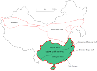
The South China Craton or South China Block is one of the Precambrian continental blocks in China. It is traditionally divided into the Yangtze Block in the NW and the Cathaysia Block in the SE. The Jiangshan–Shaoxing Fault represents the suture boundary between the two sub-blocks. Recent study suggests that the South China Block possibly has one more sub-block which is named the Tolo Terrane. The oldest rocks in the South China Block occur within the Kongling Complex, which yields zircon U–Pb ages of 3.3–2.9 Ga.

The Western Block of the North China Craton is an ancient micro-continental block mainly composed of Neoarchean and Paleoproterozoic rock basement, with some parts overlain by Cambrian to Cenozoic volcanic and sedimentary rocks. It is one of two sub-blocks within the North China Craton, located in east-central China. The boundaries of the Western Block are slightly different among distinct models, but the shapes and areas are similar. There is a broad consensus that the Western Block covers a large part of the east-central China.
The Superior Craton is a stable crustal block covering Quebec, Ontario, and southeast Manitoba in Canada, and northern Minnesota in the United States. It is the biggest craton among those formed during the Archean period. A craton is a large part of the Earth's crust that has been stable and subjected to very little geological changes over a long time. The size of Superior Craton is about 1,572,000 km2. The craton underwent a series of events from 4.3 to 2.57 Ga. These events included the growth, drifting and deformation of both oceanic and continental crusts.
The Qiantang terrane is one of three main west-east-trending terranes of the Tibetan Plateau.

The Dharwar Craton is an Archean continental crust craton formed between 3.6-2.5 billion years ago (Ga), which is located in southern India and considered as the oldest part of the Indian peninsula.