Garner Township, North Dakota | |
|---|---|
 Garner Township | |
| Coordinates: 46°45′36″N103°47′52″W / 46.76000°N 103.79778°W | |
| Country | |
| State | |
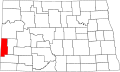
| County | Golden Valley |
| Area | |
• Total | 35.89 sq mi (92.96 km2) |
| • Land | 35.86 sq mi (92.87 km2) |
| • Water | 0.033 sq mi (0.085 km2) |
| Elevation | 2,822 ft (860 m) |
| Population | |
• Total | 12 |
| • Density | 0.33/sq mi (0.13/km2) |
| Time zone | UTC-7 (Mountain (MST)) |
| • Summer (DST) | UTC-6 (MDT) |
| Area code | 701 |
| FIPS code | 38-29340 |
| GNIS feature ID | 1037077 [2] |
Garner Township is a township in Golden Valley County, North Dakota, United States. The population was 12 at the 2020 census.