
Waun Fach is, with a summit height of 811 metres (2,661 ft), the highest mountain in the Black Mountains in south-eastern Wales. It is one of the three Marilyns over 600 m that make up the range, the others being Black Mountain and Mynydd Troed. To the north Rhos Fawr and the Radnor Forest can be seen. It is the third highest mountain in Britain south of Snowdonia. It is situated at the head of the Grwyne Fechan valley, above and to the west of the Grwyne Fawr reservoir. It has an undistinguished rounded summit. The nearby tops on the ridge, Pen Trumau and Pen y Gadair Fawr, although lower, are very much more recognisable.

Blorenge, also called The Blorenge, is a prominent hill overlooking the valley of the River Usk near Abergavenny, Monmouthshire, southeast Wales. It is situated in the southeastern corner of the Brecon Beacons National Park. The summit plateau reaches a height of 561 metres (1,841 ft).

Foel-fras is a mountain in the Carneddau range, about 10 km east of Bethesda in North Wales. It lies on the border between the counties of Gwynedd and Conwy. With a summit elevation of 944 metres, it is officially the eleventh-highest summit in Wales. Foel-fras is located at the northern end of the main ridge of the Carneddau, between Drum to the north and Foel Grach to the south with the subsidiary summit of Garnedd Uchaf between it and Foel Grach. Due south and 400 m below lies the reservoir of Llyn Dulyn, while the smaller reservoir of Llyn Anafon lies to the north.

The Mari Lwyd is a wassailing folk custom found in South Wales. The tradition entails the use of an eponymous hobby horse which is made from a horse's skull mounted on a pole and carried by an individual hidden under a sheet.

The River Rhondda is a river in South Wales with two major tributaries, Rhondda Fawr and Rhondda Fach.
Garreg Lwyd may refer to:
Garreg Lwyd is a hill in Mid Wales, between the towns of Rhayader and Llangurig. It rises to the east above the A470 as it follows the Wye Valley. The Bryn Titli Wind Farm is situated on an area of flatter moorland to the north-west. Red kites frequent the area.
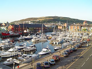
Kilvey Hill is a hill in the St. Thomas area of Swansea. It is193 metres (633 ft) high and is classed as a Sub Marilyn. The top of Kilvey Hill enjoys panoramic views of Swansea city centre, Swansea Docks, Swansea Bay, ad the Lower Swansea Valley. The historic name of the hill in Welsh is Y Bigwrn, with its summit known as Pen y Bigwrn. Currently, however, it is generally known as Mynydd Cilfái.

Mynydd-y-Garreg or Mynyddygarreg is a village in the county of Carmarthenshire, West Wales. It borders the historic town of Kidwelly.

The Afon Lwyd or Afon Llwyd is a 13-mile (21 km) long river in south-east Wales which flows from its source northwest of Blaenavon, through Abersychan, Pontnewynydd, Pontypool, Llanfrechfa and Cwmbran before flowing, at Caerleon, into the River Usk, which subsequently flows into the Bristol Channel to the south of Newport.

Tyrrau Mawr or Craig-las is a subsidiary summit of Cadair Idris in the Snowdonia National Park, in Gwynedd, northwest Wales. It lies to the west of Cyfrwy, and can be climbed by taking a west bearing from the Pony Path at Rhiw Gwredydd. Its north face is a crag, known as Craig-las. Below the crags lies Llyn Cregennen with its small island. The reflection of Craig-las from this lake is one of the famous images associated with Snowdonia.
Twmpa or Lord Hereford's Knob is a mountain in south-east Wales, forming a part of the great northwest scarp of the Black Mountains. It lies 1.86 miles (3 km) west of the border with England, and around 4.34 miles (7 km) south of Hay-on-Wye. To the northeast lies the Gospel Pass through which runs a minor road between Hay and the Llanthony Valley. A ridge known as Darren Lwyd tapers away for about 3 kilometres (1.9 mi) to the southeast of the summit.

Garreg Las is a subsidiary summit of Fan Brycheiniog in the Brecon Beacons National Park in Carmarthenshire, southern Wales. Its summit sits towards the northern end of a broad north-south ridge, Esgair Hir, at 635 metres (2,083 ft) above sea level. The hill is sometimes referred to as Twyn Swnd.

Pen Twyn Mawr is a top of Pen y Gadair Fawr in the Black Mountains in south-eastern Wales. It lies on one of the many south ridges of Waun Fach.

Rhos Dirion is a top of Waun Fach in the Black Mountains in south-eastern Wales. It is the highest point on the Rhos Dirion - Chwarel y Fan ridge.

Mynydd Llysiau is a subsidiary summit of Waun Fach in the Black Mountains in south-eastern Wales. It lies halfway between Waun Fach and Pen Allt-mawr. It is a distinguished summit with a steep eastern face.

The Afon Llyfnant, also known as the River Llyfnant, is a short river in Ceredigion, on the west coast of Wales. The river rises in the mountains south of Machynlleth, reaches the hill walk of Uwch Garreg and then plunges over a series of waterfalls known as Pistyll y Llyn, into a ravine, descending towards the River Dyfi near Dovey Junction railway station.

The Elenydd is an upland area of Mid Wales, extending across parts of northern and eastern Ceredigion and Powys between Aberystwyth and Rhayader. Elenydd is also a name given to the medieval commote of Cwmwd Deuddwr which covered approximately the same area.
Llanfaethlu is a village and community in the north west of Anglesey, in north-west Wales. The community population taken at the 2011 Census was 553. The village takes its name from the Church of Saint Maethlu. The community includes Llanfwrog.

Cwm Gwaun is a community and valley in north Pembrokeshire, Wales. The community is centred around Pontfaen, a parish and hamlet 4 miles (6.4 km) southeast of Fishguard, and includes the ancient parish of Llanychaer. In 2011, the population was 313. The valley is known for its unspoilt nature and old-world pub, and there are numerous other listed buildings.
