Sarlahi, a part of Province No. 2, is one of the seventy-seven districts of Nepal. According to new laws, combination of more than 2 or 4 villages makes a municipality, which covers an area of 1,259 km2 (486 sq mi) and had a population of 635,701 in 2001 and 769,729 in 2011.

Nepalgunj, also spelled Nepalganj, is a Sub-Metropolitan City in Banke District, Nepal. It lies on the Terai plains near the southern border with Bahraich district in Uttar Pradesh, India. Nepalgunj is 153 kilometers south-west of Ghorahi and 16 km south of Kohalpur. Former Village Development Committee: Udayapur, Bhawaniyapur, Piprahawa, Jaispur, Paraspur, Indrapur, Khaskarkado, Bashudevpur, Manikapur and Puraina were added to territory in order to make it Sub metropolitan city on 2071 Paush 28 and later Puraini was also added in list on 2072 Paush 21. Further, while restructuring of local levels nationwide, ward no. 23 was taken out to Janaki Rural Municipality and ward no. 7 of Hirminiya VDC was added to Nepalgunj.<Bishnu Pasa> is famous in Nepalgunj
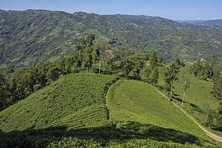
Ilam is one of four urban municipalities of Ilam District, which lies in the Mahabharata hilly range of Province No. 1, eastern Nepal. Ilam also acts as the headquarters of Ilam District. Being the largest producer region for Nepali tea, its tea farms comprise a major tourist attraction in Province No. 1. Ilam is also famous for its natural scenery and landscapes as well as its diverse agricultural economy which specializes in horticultural crop production.

Damak is one of the oldest municipalities in Jhapa District in Province No. 1 of Nepal. It is situated between the Ratuwa River in the east and the Maawa River in the west. It has Sivalik Hills in its north and ends with the intersection of Ratuwa River and Mawa River in the south. Mahendra Highway crosses this municipality nearly bisecting it. It is the largest city in Jhapa District as well as in Mechi zone with a population of 75,743 in 2011 A.D
Birendranagar is a city in Surkhet District in Karnali province of Nepal.

Solududhkunda (earlier:Dudhkunda) is the only municipality of Solukhumbu District. Located in Province No. 1 of Nepal. The town of Salleri, which is located within the municipality is the headquarter of Solukhumbu District It was formed in 2014 by merging four VDCs: Salleri, Garma, Loding Tamakhani and Beni and was divided into 9 wards. Total area of the municipality had 254.3 square kilometres (98.2 sq mi) and population of municipality had 20,399 individuals living in 5,368 households.
Naubise is a village development committee in Dhading District in the Bagmati Zone of central Nepal. At the time of the 2011 Nepal census it had a population of 25621 and had 3239 houses in it.
Rigaun or Ree gaun is a village development committee in Dhading District in the Bagmati Zone of central Nepal. At the time of the 1991 Nepal census it had a population of 5218 and had 875 houses in it. Ree Gaun is located in the Northern part of Dhading. It consists of wards no 1 & 2 of Gangajamuna Rural Municipality, State 3, Dhading Nepal. There are 90% people of the Tamang ethnic group, and some are Gurung, Kami (BK), Damai. The main occupation of this area is agriculture.
Khaskarkando is a town in Banke District in the Bheri Zone of south-western Nepal. At the time of the 1991 Nepal census it had a population of 4,582 and had 769 houses in the town. Now, it is a part of Nepalgunj sub-metropolitan city.
Kavre Nitya Chandeswori popularly known as "Kavre" is a village development committee in Kavrepalanchok District in the Bagmati Zone of central Nepal. Two of its V.D.C's are included in Dhulikhel Municipality in the year 2015 A.D. At the time of the 2011 Nepal census it had a population of 4927 in 1042 individual households.
Mahat Gaun is a market center in Chandannath Municipality in Jumla District in the Karnali Zone of north-western Nepal. The formerly village development committee was merged with Mahat Gaun, Talium, Kartik Swami, Chandannath village development committees to form the new municipality. At the time of the 1991 Nepal census it had a population of 2501 persons living in 496 individual households.
Ekatappa is a town and Village Development Committee in Ilam District in the Mechi Zone of eastern Nepal. At the time of the 1991 Nepal census it had a population of 4,320 persons living in 784 individual households.
Hariwan Municipality is one of the new Municipality declared by Nepal Government on May 18, 2014. It is situated in Sarlahi District Janakpur zone, Nepal. It is formed by joining four contemporary VDCs namely Atrouli, Sasapur, Ghurkauli and Harion VDCs that spreads to 88.1 sq. km. It has been divided into 11 wards with administration center in Harion Bazar. According to Nepal Population Census 2011, this municipality has total population of 42,783.
Ishworpur is a Municipality in Sarlahi District in the Janakpur Zone of south-eastern Nepal. The municipality was established on 18 May 2014 by merging the existing Bela, Bhaktipur, Gaurishankar and Ishwarpur VDCs. At the time of the 1991 Nepal census it had a population of 14,014 people living in 249 individual households.
Lalbandi is a Municipality in Sarlahi District in the Janakpur Zone of south-eastern Nepal. The municipality was established on 18 May 2014 by merging the existing Jabdi, Lalbandi and Pattharkot VDCs. At the time of the 2011 Nepal Census it had a population of 59,395 people living in 3295 individual households.There are 17 wards in this municipality.It is the largest municipality in Sarlahi district.The office of this municipality is in ward no.6 Located in the Lalbandi.Lalbandi Bazar, located on the East West Mahendra highway, is one of the main trading areas within the municipal area.Bordering East Ishwarpur Municipality, West Hariwan and Haripur Municipality, North Sindhuli District and bordering Haripur and Ishwarpur in the south, Lalbandi Bazar is the main trading site of the district.

Kataiya ( ) is a village development committee (VDC) in the central part of Saptari in the Sagarmatha Zone of south-eastern part of Nepal. This VDC is about 5km south of Rupani bazaar, a bazaar through which the East-West Highway passes and about 15km north of Indo-Nepal border. It is about 8km north-west of the headquarter of Saptari district as well as Sagarmatha zone, Rajbiraj. The VDC comprises 9 wards. It lies in Illaka No. 11. On the basis of 2011AD. census, there are 9,554 population living in about 1,500 individuals houses.

Bhadrapur is a town and municipality in Jhapa District in the Mechi Zone of southeastern Nepal. It lies on the right bank of the Mechi River, Nepal's eastern municipality borders with Bihar state, India on south and West Bengal state on north. There is a border crossing with customs office for goods. Galgalia village in Kishanganj District borders with Bhadrapur

Phidim Municipality is the headquarters of the Panchthar District in the Mechi Zone of eastern Nepal. Phidim was upgraded to a 'municipality' from a 'village', when a development committee merged with other VDCs - including the Phidim, Chokmagu and Siwa villages - on May 18, 2014. It offers a route for trekkers and locals, who travel to and from the Taplejung district bordering with the Tibetan Autonomous Region of China. It is also a commercial hub for the rural surroundings.

Kawasoti (कावासोती) is a municipality in Nawalpur District, Gandaki Pradesh, Nepal. It is 31 km west of Bharatpur and 85 km (53 mi) east of Butwal, approximately on the middle of Mahendra Highway. The Naryani River flows south of it, and the Mahabharat Range is north of it.
Garuda is a Municipality in Rautahat District in the Narayani Zone of south-eastern Nepal. It is a newly created municipality by merging 7 former Village development committees namely Garuda Bairiya, Malahi, Basbiti Jingadiya, Gedahiguthi, Jayanagar, Mahamadpur and Pothiyahi [1].