Gayton, Staffordshire

Last updated

Gayton
Cherry Lane - geograph.org.uk - 264497.jpg
Cherry Lane, Gayton
Staffordshire UK location map.svg
Red pog.svg
Gayton
Location within Staffordshire
Population154 (2011) [1]
OS grid reference SJ978285
District
Shire county
Region
Country England
Sovereign state United Kingdom
Post town Stafford
Postcode district ST18
Dialling code 01889
Police Staffordshire
Fire Staffordshire
Ambulance West Midlands
UK Parliament
List of places
UK
England
Staffordshire
52°51′14″N2°01′37″W / 52.854°N 2.027°W / 52.854; -2.027

Gayton is a small rural village and civil parish in Staffordshire, located approximately 1 mile from the A51 between Stone and Stafford. In 2001 it had 167 residents, with 1 letter box, one bus stop, and new village hall. The post box is owned now by the village as is the telephone booth. The post code for Gayton properties normally start with ST18.

Contents

History

The name Gayton is believed to mean either "a primitive enclosure approached from a gate or narrow way, from the Anglo-Saxon 'geat'" or "'Gaegas dwelling', derived from an Old English personal name" [2] ).

Gayton (recorded as Gaitone [2] ) was listed in the Domesday Book (1086 AD), together with nearby Amerton, in the Pirehill hundred, as having 8 households, with 10 villagers and 6 smallholders, and the Tenant-in-Chief was Earl Roger of Shrewsbury. Agriculturally, they had 4 ploughlands, 1 lord's plough teams and 4 men's plough teams, and had a value to lord of £1.5, with the total amount of tax assessed 0.5 geld units. [3] The village was documented to be held by Aelmer and Alric. [4] It was also documented to have woodland of "1 league in length and half a league in breadth". [2]

The Hearth Tax Assessment of 1666 documented that Gayton had 33 households liable for the payment of 48 hearths. The largest property was owned by George White who had six hearths. Seven households were deemed too poor to be able to pay the tax. [2]

In 1851, Gayton was a 'scattered village', with 291 residents, and with 'commanding views over of Sandon Column, the plantations of the Earl of Harrowby, and the picturesque ruins of Chartley Castle.' The parish contained '1475 acres 2 roods 26 perches of fertile, loamy land, of which Earl Ferrers is the principal owner, and lord of the manor'. [5]

Gayton was described in John Marius Wilson's Imperial Gazetteer of England and Wales in 1870-72 like this:

GAYTON, a parish in the district and county of Stafford; near the river Trent and the Grand Trunk canal, 1 mile NE of Weston r. station, and 5 NE of Stafford. It has a post office under Stafford. Acres, 1, 270. Real property, £2, 833. Pop., 249. Houses, 63. The living is a vicarage in the diocese of Lichfield. Value, £136.* Patron, Mrs. Mould. The church is good; and there are charities £5. [6]

The most significant Post-Medieval development in the Gayton area happened in the mid-nineteenth century, when the North Staffordshire Railway opened in 1848, with a stop in nearby Weston and Ingestre railway station. The station was roughly 3/4 of a mile southwest of the village, but it closed in 1963. During World War Two a Royal Observer Corps Monitoring Post was installed south of the village on Wadden Farm, and is still in good condition today. It was built to act as an early warning system for nearby Hixon Airfield. [4]

Demography

Population change
Year180118111821183118411851188118911901191119211931195119612001
Households [7] 6165645749464242444463 [8]
Population [9] 273261284296291264236236180201185182158156167 [10]
Population Change in Gayton 1801-2001 Gayton population graph1.jpg
Population Change in Gayton 1801-2001

Gayton, in the 2001 Census, has a population of 167 [10] in a total of 63 households. [8] The population has fallen from a peak of 296 in 1831 [11] , since which the population seems to have steadily decreased. This is most likely due to rural to urban migration from small villages like Gayton to bigger centres. The decline in agriculture in England is also a possible contributor to the decreasing population.

1831 Occupational statistics

Gayton Occupation Categories, 1831 [12]
1831 Occupation Categories1831
Farmers employing Labourers9
Farmers not employing Labourers15
Agricultural Labourers20
Manufacturing0
Retail & Handicrafts22
Capitalists, Professionals0
Labourers (Non-Agricultural)1
Servants5
Other7

The occupational structure of Gayton males aged 20 or over, as reported in the 1831 Census, shows that the majority of workers were either farmers or agricultural labourers, as was typical for a rural community in the 1830s. There were also a relatively high number of men working in retail and handicrafts. However, as Gayton was relatively distant from any major manufacturing or commercial centres, there were no people residing in Gayton from these occupations. [12]

Brook Farm, Gayton Brook Farm, near Gayton - geograph.org.uk - 279323.jpg
Brook Farm, Gayton
Country lane leading to Gayton A country lane, Hartley Green - geograph.org.uk - 279316.jpg
Country lane leading to Gayton

1881 Occupational statistics

Gayton Occupation Categories, 1881 [13]
1881 Occupational OrdersMaleFemale
General/Local Government10
Professionals01
Domestic Service or Offices111
Commercial Operations11
Agriculture321
Animals10
Workers in House, Furniture and Decorations10
Workers in Carriages and Harnesses40
Workers in Food and Lodging21
Workers in Dress23
Workers in Various Mineral Substances20
Workers in General or Unspecified Commodities100
Persons without specified Occupations36
Unknown Occupation040

The 1881 Occupational Statistics show that a majority of male workers worked in the agricultural sector, while women (if they worked) worked more in domestic service. The number of people who were in professional and governmental occupations was minimal due to Gayton's rural location, and many women were unaccounted for, these most likely being housewives. Compared to the 1831 statistics, the overall pattern of employment was roughly the same as in 1831, however, the inclusion of women into the statistics gives a more complete view of the employment patterns of the nineteenth century in rural communities. [13]

Amenities

Gayton has one post box, one bus stop and a village hall. The nearest Post Office is in the village hall of Weston, which opened on 1 March 2012. [14] There also used to be a hotel, the Gayton Hotel, which opened in 1904, however, this has since been demolished and houses built upon the site. [15]

Village Hall

Gayton Village Hall Gayton Village Hall - geograph.org.uk - 821937.jpg
Gayton Village Hall

Gayton Village Hall is a multi-purpose facility, located just off Church Lane, which has a fully licensed bar, and is used for many local events including flower arranging, coffee mornings and twice monthly get together meets. [16]

Public Transport

There is no bus service to or from Gayton. The nearest railway station is Stafford railway station, with regular services to London, Stoke-on-Trent, Birmingham, Manchester and Liverpool.

St. Peter's Church

St. Peter, Gayton St. Peter, Gayton - geograph.org.uk - 119573.jpg
St. Peter, Gayton

St. Peter is the parish church of Gayton, and is part of the Diocese of Lichfield. [17] The oldest part of the church is the archway between the nave and the chancel, dating from the 12th Century, with the body of the chancel added in the 13th century. [4] The earliest parish register dates from 1584. [2] The tower in the west end was added in 1732, the same time as the blocking of the archways in the northern arcades, and the south aisle of the nave and its porch, the east wall of the chancel and the vestry attached to its north wall all date from a rebuild undertaken during the 1870s. [4]

In 1851, St. Peter was described in History, Gazetteer and Directory of Staffordshire by William White as

"The Parish Church, St Peter, was partly rebuilt about 120 years ago, and appears to have been much larger, for it is said that an ancient tomb, now in the churchyard, with a recumbent effigy of one of the Ferrers family upon it, was formerly in one of the aisles. The perpetual curacy is in the patronage of the Mrs Mould, and the incumbency is held, with that of Stowe, by the Rev William Hides, BA." [From History, Gazetteer and Directory of Staffordshire, William White, Sheffield, 1851] [18]

Gayton is also the documented site of a Holy Well used in medieval and post-medieval times, although this is believed to have dried out. [4]

Notable residents

James Robert Oldham, Yorkshire cricketer

See also

Related Research Articles

<span class="mw-page-title-main">Borough of Stafford</span> Non-metropolitan district and borough in England

The Borough of Stafford is a local government district with borough status in Staffordshire, England. It is named after Stafford, its largest town, which is where the council is based. The borough also includes the towns of Stone and Eccleshall, as well as numerous villages and surrounding rural areas.

<span class="mw-page-title-main">Edingale</span> Human settlement in England

Edingale is a village and civil parish in Lichfield District, Staffordshire, England. It lies on the River Mease, around 7 miles (11 km) north of Tamworth. Historically, the village is shared with Derbyshire. In 2001 the parish had a population of 598, increasing to 632 at the 2011 census.

<span class="mw-page-title-main">Westbury, Shropshire</span> Human settlement in England

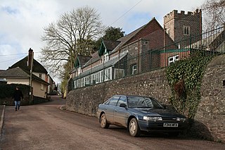
Westbury is a village and parish in Shropshire, England. It includes the settlements of Caus Forest, Lake, Marche, Newtown, Stoney Stretton, Vennington, Wallop, Westbury, Whitton, Winsley and Yockleton. It lies 8 miles (13 km) west of Shrewsbury, close to the Wales-England border. It is located at 135 m altitude. It had a population of 1,352 according to the 2011 census. In 2005, Westbury parish expanded with the annexation of half of the former Wollaston parish.

<span class="mw-page-title-main">Weston-under-Lizard</span> Human settlement in England

Weston-under-Lizard is a village and former civil parish, now in the parish of Blymhill and Weston-under-Lizard, in the South Staffordshire district of Staffordshire, England. It is known as Weston-under-Lizard to distinguish it from Weston-on-Trent. It should not be confused with the village of Weston, to the north east of Stafford. In 1961 the parish had a population of 294. On 1 April 1986 the parish was abolished and merged with Blymhill to form "Blymhill and Weston-under-Lizard".

<span class="mw-page-title-main">Rickinghall Inferior</span> Human settlement in England

Rickinghall Inferior is a civil parish in the Mid Suffolk district of Suffolk, England. According to the 2011 census there were 233 males and 216 females in this civil parish, for a total population of 449. It includes the western part of the village of Rickinghall and is adjacent to the village and parish of Wattisfield. The old road from the market town of Bury. St Edmunds to the City of Norwich and the town of Great Yarmouth passes through the centre of the village but the new road, the A143, uses a by-pass to the East.

<span class="mw-page-title-main">Ashton, Devon</span> Human settlement in England

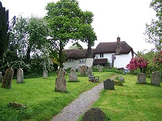
Ashton is a civil parish in the Teignbridge district of Devon, England. According to the 2001 census it had a population of 174, and it had a population of 203 according to the 2011 census. The parish consists of two villages, Higher Ashton and Lower Ashton, and is on the edge of the Dartmoor National Park. The France Brook flows through most of Ashton just south of its main road, and along Ashton's eastern boundary flows the River Teign. The parish is located approximately 13 km north of Newton Abbot, and roughly 10 km to the south west of its nearest city, Exeter. Historically, Ashton has primarily been based inside the agricultural sector, but one of its most notifiable landmarks is the St John the Baptists church located in the Higher Ashton district.

<span class="mw-page-title-main">Stanton, Staffordshire</span> Village in Staffordshire, England

Stanton is a small village situated at the eastern end of the Weaver Hills, Staffordshire, England.

<span class="mw-page-title-main">Parham, Suffolk</span> Village and civil parish in Suffolk, England

Parham is a village and civil parish in the East Suffolk district of Suffolk in eastern England. Located seven miles north of Woodbridge, in 2005 it had a population of 300, reducing to 263 at the 2011 census and according to the 2011 census there were 129 males and 134 females living at this time.

<span class="mw-page-title-main">Bramshall</span> Village in Staffordshire, England

Bramshall is a village and former civil parish, now in the parish of Uttoxeter Rural, in the East Staffordshire district, in the county of Staffordshire, England. It is to the west of Uttoxeter. It has a new housing estate to the north of it. In 1931 the parish had a population of 173.

<span class="mw-page-title-main">Leathley</span> Village and civil parish in North Yorkshire, England

Leathley is a village and civil parish in the Harrogate district of North Yorkshire, England, the parish includes the townships of both Castley and Leathley. It is near the border with West Yorkshire and the River Wharfe, 1 mile north-east of Otley. The B6161 runs through the village, connecting Leathley with Killinghall in the North and Pool-in-Wharfedale in the south.

<span class="mw-page-title-main">Langford, Nottinghamshire</span> Village and civil parish in Nottinghamshire, England

Langford is a village and civil parish in Nottinghamshire, England. It is located four miles north-east of Newark-on-Trent and two miles east from the River Trent. Population for the civil parish was 104 at the 2021 census. It lies along the A1133 which comes off of the A46 road.

<span class="mw-page-title-main">Whitgreave</span> Human settlement in England

Whitgreave is a very small village a few miles to the NNW of Stafford situated midway between the M6 motorway to the west and the A34 trunk road to the east.

<span class="mw-page-title-main">Weston, Staffordshire</span> Village in Staffordshire, England

Weston is a village and civil parish. within the English county of Staffordshire. The parish is in the local authority of Stafford.

<span class="mw-page-title-main">Ousden</span> Village in Suffolk, England

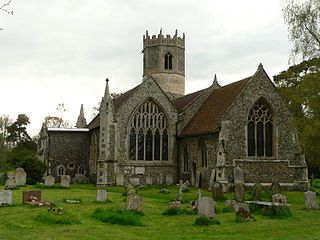
Ousden is a village and civil parish in the West Suffolk district of Suffolk in eastern England. It is located around 6 miles (10 km) west of Bury St Edmunds and 72 miles (116 km) north of London, and as of 2011, its population is 266. The village has an Anglican church of St Peter's and a chapel in the cemetery dedicated to St Barnabas.

<span class="mw-page-title-main">Newborough, Staffordshire</span> Village in Staffordshire, England

Newborough is a village and civil parish in the county of Staffordshire, England. It is located 3 miles (5 km) south west of Hanbury and 8 miles (13 km) west of Burton-upon-Trent. Newborough has a pub, a school and a church. At the 2011 UK census, the population stood at 476, comprising 240 males and 236 females. Newborough is part of the Yoxall ward of East Staffordshire.

<span class="mw-page-title-main">Swilland</span> Human settlement in England

Swilland is a village and civil parish, in the East Suffolk district, in the English county of Suffolk. It is north of the large town of Ipswich. Swilland has a church called St Mary's Church and a pub called The Moon & Mushroom Inn which has been awarded Suffolk Pub of The Year on two occasions by the Evening Star. Swilland shares a parish council with Witnesham called "Swilland and Witnesham Grouped Parish Council".

<span class="mw-page-title-main">Lindsell</span> Village in Essex, England

Lindsell is a village and civil parish in the district of Uttlesford in the county of Essex, England. Nearby settlements include the parish hamlets of Holder's Green and Bustard Green. The parish church is dedicated to St Mary The Virgin.

<span class="mw-page-title-main">Standon, Staffordshire</span> Village in Staffordshire, England

Standon is a village and civil parish in the Stafford district, in the county of Staffordshire, England. Standon has a church called Church of All Saints and one school called All Saints C of E First School. In 2001 the population of the civil parish of Standon was 823, and in the 2011 census it had a population of 879.

<span class="mw-page-title-main">Chell, Staffordshire</span> Suburb of Stoke-on-Trent, England

Chell is a suburb of the city of Stoke-on-Trent in the ceremonial county of Staffordshire, England, that can be subdivided into Little Chell, Great Chell and Chell Heath. It lies on the northern edge of the city, approximately 1-mile (1.6 km) from Tunstall, 2 miles (3.2 km) from Burslem and 3 miles (4.8 km) from the county border with Cheshire. Chell borders Pitts Hill to the west, Tunstall to the south west, Stanfield and Bradeley to the south, with the outlying villages of Packmoor and Brindley Ford to the north and Ball Green to the east. Since 2011 the area has been divided into the electoral wards of Bradeley & Chell Heath, Great Chell & Packmoor and Little Chell & Stanfield.

<span class="mw-page-title-main">Poughill, Devon</span> Village in Devon, England

Poughill is a village and civil parish in the Mid Devon district, in the county of Devon, England. It lies 5 miles (8 km) north of Crediton. In 2011, the parish had a population of 216.

References

  1. "Civil Parish population 2011" . Retrieved 8 December 2015.
  2. 1 2 3 4 5 "Staffordshire Past Track-Introduction: Gayton". Archived from the original on 11 September 2012. Retrieved 25 April 2012.
  3. "Gayton". domesdaymap.co.uk. Domesday Book. Archived from the original on 13 July 2012. Retrieved 9 March 2012.
  4. 1 2 3 4 5 "GAYTON HISTORY". Archived from the original on 4 May 2014. Retrieved 12 March 2012.
  5. "Trade Directory for Gayton, 1851". Staffordshire Places: Staffordshire and Stoke-on-Trent Archive Service. Archived from the original on 13 September 2012. Retrieved 9 March 2012.
  6. John Marius Wilson. "Gayton, Staffordshire". Imperial Gazetteer of England and Wales, 1870-1872. Retrieved 6 March 2012. .
  7. "Gayton CP/AP through time – Housing Statistics – Total Houses". UK Census Data. Retrieved 9 March 2012.
  8. 1 2 "Neighbourhood Statistics, Gayton Households". 2001 Census.
  9. "Gayton CP/AP through time – Population Statistics – Total Population". UK Census Data. Retrieved 9 March 2012.
  10. 1 2 "Neighbourhood Statistics, Gayton Population". 2001 Census.
  11. "Gayton CP/AP through time – Population Statistics – Total Population". 1831 Census Data. Retrieved 9 March 2012.
  12. 1 2 "Gayton CP/AP through time – Industry Statistics – Males aged 20 & over, in 9 occupational Categories". 1831 Census Data. Retrieved 12 March 2012.
  13. 1 2 "Gayton CP/AP through time". 1881 Census Data. Retrieved 23 April 2012.
  14. "Boost for Staffordshire village Weston in post office fight". birminghampost.net. Retrieved 12 March 2012.
  15. "Staffordshire Past Track-Gayton Hotel, Gayton Staffordshire". Archived from the original on 10 September 2012. Retrieved 25 April 2012.
  16. "Gayton Village Hall". Archived from the original on 11 February 2012. Retrieved 12 March 2012.
  17. Ron Baxter. "Corpus of Romanesque Sculpture in Britain and Ireland: St. Peter, Gayton, Staffordshire". Archived from the original on 20 April 2013. Retrieved 12 March 2012.
  18. "GENUKI: Gayton" . Retrieved 12 March 2012.

Commons-logo.svg Media related to Gayton, Staffordshire at Wikimedia Commons