
The Yamuna is the second-largest tributary river of the Ganges by discharge and the longest tributary in India. Originating from the Yamunotri Glacier at a height of about 4,500 m (14,800 ft) on the southwestern slopes of Bandarpunch peaks of the Lower Himalaya in Uttarakhand, it travels 1,376 kilometres (855 mi) and has a drainage system of 366,223 square kilometres (141,399 sq mi), 40.2% of the entire Ganges Basin. It merges with the Ganges at Triveni Sangam, Prayagraj, which is a site of the Kumbh Mela, a Hindu festival held every 12 years.

Delhi has significant reliance on its transport infrastructure. The city has developed a highly efficient public transport system with the introduction of the Delhi Metro, which is undergoing a rapid modernization and expansion since 2006. There are 16.6 million registered vehicles in the city as of 30 June 2014, which is the highest in the world among all cities, most of which do not follow any pollution emission norm, while the Delhi metropolitan region has 11.2 million vehicles. Delhi and NCR lose nearly 42 crore man-hours every month while commuting between home and office through public transport, due to the traffic congestion. Therefore, serious efforts, including a number of transport infrastructure projects, are under way to encourage usage of public transport in the city.

East Delhi is an administrative district of Delhi in India. It is bounded by the Yamuna River on the west, North East Delhi to the north, Ghaziabad District of Uttar Pradesh state to the east, and Gautam Buddha Nagar District of Uttar Pradesh to the south. Administratively, the district is divided into three subdivisions: Gandhi Nagar, Preet Vihar, and Mayur Vihar.
The Delhi–Noida Direct Flyway or DND Flyway is India's first 8-lane wide, 7.5 km (4.7 mi) long access-controlled expressway in Delhi NCR. It connects Maharani Bagh and Nizamuddin on the western side to Noida (Sector-15A) and Mayur Vihar on the eastern side of the Yamuna river. The Noida Toll Bridge Company Limited (NTBCL) owned by IL&FS, operate and maintains it on build-own-operate-transfer (BOOT) basis. The expressway, which was opened to the public in January 2001 was constructed by Japan based Mitsui-Marubeni Corporation Ltd. The length of main carriageway (MCW), including bridge on Yamuna river is 6.0 km. Rest 1.5 km is Mayur Vihar link (MVL), which was opened in 2008.

Okhla is an urban neighbourhood located near the Okhla barrage in the South East Delhi district of Delhi near the border between Delhi and Uttar Pradesh. Okhla has lent its name to the nearby planned township of New Okhla Industrial Development Authority or NOIDA. Okhla is also an assembly constituency.
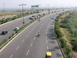
Delhi, a major metropolitan region of India, is connected to various parts of country through several national highways and expressways. All the highways and expressways from Delhi lead to Haryana or Uttar Pradesh and continue from there.

The East Indian Railway Company, operating as the East Indian Railway, introduced railways to East India and North India, while the Companies such as the Great Indian Peninsula Railway, South Indian Railway, Bombay, Baroda and Central India Railway and the North-Western Railway operated in other parts of India. The company was established on 1 June 1845 in London by a deed of settlement with a capital of £4,000,000, largely raised in London.
The Western Peripheral Expressway (WPE) or Kundli–Manesar–Palwal Expressway, is an operational 6-lane, 135.6 km (84.3 mi)-long Expressway in the Haryana state of India. Along with the Eastern Peripheral Expressway, the Western Peripheral Expressway is expected to divert more than 50,000 heavy vehicles away from Delhi, which will help to maintain good air quality in Delhi. Western Peripheral Expressway along with Eastern Peripheral Expressway completes the largest Ring Road around Delhi. There are 10 tolled entries and exits, from north to south - Kundli, Kharkhoda, Bahadurgarh, Badli, Fartukhnagar, Panchgaon, Manesar, Taoru, Sohna & Palwal. Toll rate notified in December 2018 is INR1.35 per km for cars, INR2.18 per km for light motor vehicles, INR4.98 per km for trucks and buses, and two wheelers are not permitted on the expressway.

Yamuna Expressway is a 6-lane wide and 165.5 km (102.8 mi) long access-controlled expressway in the Indian state of Uttar Pradesh. It is presently India's sixth longest expressway and connects Greater Noida with Agra. It was built to de-congest the older Delhi–Agra national highway (NH-2) or Mathura Road.
The Eastern Peripheral Expressway (EPE) or Kundli–Ghaziabad–Palwal Expressway is a 135 km (84 mi) long, 6-lane wide expressway passing through the states of Haryana and Uttar Pradesh in India. The expressway starts from the Western Peripheral Expressway at Kundli, Sonipat, passing through Baghpat, Ghaziabad and Noida districts in UP and Faridabad district in Haryana before rejoining the Western Peripheral Expressway near Dholagarh, Palwal. Eastern Peripheral Expressway along with Western Peripheral Expressway completes the largest Ring Road around Delhi. The Eastern Peripheral Expressway was declared as National Expressway 2 (NE-2) in March 2006.

Gandhi Nagar is a residential area in the East Delhi district of Delhi in the Trans-Yamuna area. It is most known for Gandhi Nagar Market, which is Asia's biggest readymade garments/textile market. Gandhi Nagar has many shops and factories.

The Howrah–New Delhi main line is a railway line connecting Delhi and Kolkata cutting across northern India. The 1,531 km (951 mi) railway line was opened to traffic in 1866 with the introduction of the "1 Down/2 Up Mail" train.

Majnu-ka-tilla (MT) is a colony in Delhi, India that was established around 1950. Majnu-ka-tilla is officially called New Aruna Nagar Colony, Chungtown, and Samyeling. It is part of North Delhi district and is located at the bank of the Yamuna River (NH-1) near ISBT Kashmiri Gate.
Geeta Colony was an assembly constituency of the East Delhi, New Delhi, India from 1967 to 2008.
The ITO barrage, also Indraprastha barrage and ITO Bridge, is a 552 meter barrage on Yamuna River, top of which also serves as the bridge on the Paharganj-Gaziabad Vikas marg. Yamuna flows for 48 km in Delhi, including 22 km from Wazirabad barrage where it enters Delhi to Okhla barrage after which it enters Haryana. Upstream barrage from ITO barrage in Delhi is Wazirabad barrage (north) and downstream is Okhla barrage (south). Yamuna has a total of 6 barrages, from north-west to south-east, Dakpathar Barrage (Uttarakhand), Hathni Kund Barrage, Wazirabad barrage, ITO barrage, Okhla barrage and Mathura barrage.
The Delhi–Mumbai Expressway is a 1,350 km long, 8-lane wide under-construction access-controlled expressway connecting India's national capital New Delhi to its financial capital Mumbai. The foundation stone for the project was laid by union minister of Road Transport & Highways Nitin Gadkari in the presence of Sushma Swaraj and Arun Jaitley on 8 March 2019 and it was inaugurated by Prime Minister Narendra Modi. The total project value including the land acquisition cost is around ₹1,00,000 crores. It is expected to be completed by 2026.

The Signature Bridge is a cantilever spar cable-stayed bridge which spans the Yamuna river at Shourya section, connecting Wazirabad to East Delhi. It is India's first asymmetrical cable-stayed bridge. The pylon of the Signature bridge is the tallest structure in Delhi and is double the height of Qutub Minar with its 154-metre high viewing box, which is a location where visitors take selfies. It shortens the travel time between north and northeast Delhi.

The Old Yamuna Bridge, also known as Lohe-ka-Pul, or "bridge number 249", located in Delhi, is one of the longest and oldest bridges in India. Construction of the bridge began in 1863 and finished in 1866, with it opening for public use in 1867. The bridge is a double-decked steel truss bridge that runs east-west across the Yamuna river, connecting the district of Central Delhi to the district of Shahdara. It was constructed in 1866 by the East India Railway at a cost of £1,616,335, and has a total length of 2,640 feet (804.67 m) feet with 12 spans of 202.5 feet (61.72 m) each.
New Nizamuddin bridge is one of the main bridge that connects Trans Yamuna in the east Delhi with Ring Road in South Delhi across river Yamuna. Also known as Indo-Japanese Friendship Bridge. There are eight motorway Bridges across Yamuna this is the sixth motorway bridge from north to south there are two more motorway Bridges south of this. The bridge was built in 1970 and later in 1998 widened to 8 lanes.
The Trans-Haryana Expressway or the Ambala–Narnaul Expressway (NH-152D) is a 227-km long, 6-lane wide greenfield access-controlled expressway, connecting the cities of Ambala and Narnaul in the state of Haryana. The expressway connects Gangheri village in Kurukshetra district with Surana village on Narnaul Bypass (NH-148B) in Mahendragarh district. It passes via Kaul, Pundri, Pillu khera, Julana, Kalanaur, Charkhi Dadri and Kanina. It will reduce the distance from Chandigarh to Delhi, Narnaul, and Jaipur, thus decongesting NH-44 and NH-48.
