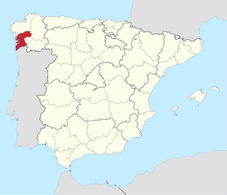
Galicia is an autonomous community of Spain and historic nationality under Spanish law. Located in the northwest Iberian Peninsula, it includes the provinces of A Coruña, Lugo, Ourense, and Pontevedra.

Lugo is a province of northwestern Spain, in the northeastern part of the autonomous community of Galicia. It is bordered by the provinces of Ourense, Pontevedra, and A Coruña, the principality of Asturias, the State of León, and in the north by the Cantabrian Sea.

Ourense is a Spanish province, in the southeastern part of the autonomous community of Galicia. It is bordered by the provinces of Pontevedra to the west, Lugo to the north, León and Zamora, to the east, and by Portugal to the south. With an area of 7,278 square km., it is the only landlocked province in Galicia. The provincial capital, Ourense, is the largest population centre, with the rest of the province being predominantly rural.
Pontevedra is a province of Spain along the country's Atlantic coast in southwestern Europe. The province forms the southwestern part of the autonomous community of Galicia. It is bordered by the provinces of A Coruña, Lugo, and Ourense, the country of Portugal and the Atlantic Ocean. The official languages of the Pontevedra province are Spanish and Galician. There is a public institution called the Provincial Deputation of Pontevedra, whose head office is in Pontevedra city, that provides direct services to citizens such as technical, financial and technological support to the councils of the 62 municipalities of the province of Pontevedra.

The Cantabrian Sea is the term used mostly in Spain to describe the coastal sea of the Atlantic Ocean that borders the northern coast of Spain and the southwest side of the Atlantic coast of France. It extends from the cape Estaca de Bares in the province of A Coruña, to the mouth of the river Adour, near the city of Bayonne on the coast of the department of Pyrénées-Atlantiques in French Basque Country.
The Xunta de Galicia is the collective decision-making body of the government of the autonomous community of Galicia, composed of the President, the Vice-President(s) and the specialized ministers (Conselleiros).

The University of Vigo is a public university located in the city of Vigo in the Province of Pontevedra, Galicia, Spain. There are three campuses:

The Rías Baixas are a series of four estuarine inlets located on the southwestern coast of Galicia, Spain. They are the Ría de Muros e Noia, the Ría de Arousa, the Ría de Pontevedra, and the Ría de Vigo. The northernmost Rías Baixas begin below Cape Finisterre while the southernmost rias border the Portuguese coast, taking up the southern part of the Province of Coruña and the entire Province of Pontevedra. Its capital is the city of Pontevedra. Due to unique conditions, the Rías Baixas are rich in marine life which helps the fishing and aquaculture industry of the area. Beaches, marinas, distinctive towns, and plenty of water activities also attract tourists, providing another source of income.

The Minho or Miño is the longest river in Galicia, sharing the border with Portugal, with a length of 340 kilometres (210 mi). By discharge, it is the fourth river of the Iberian peninsula, after the Douro, Ebro, and Tagus.

Galicians are a Celtic-Romance ethnic group from Spain that is closely related to the Portuguese people and has its historic homeland is Galicia, in the north-west of the Iberian Peninsula. Two Romance languages are widely spoken and official in Galicia: the native Galician and Spanish.

The Cíes Islands are an archipelago off the coast of Pontevedra in Galicia, Spain, in the mouth of the Ria de Vigo. They were declared a Nature Reserve in 1980 and are included in the Atlantic Islands of Galicia National Park created in 2002.
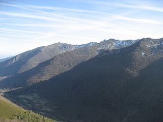
The Serra dos Ancares is a mountain range of the Galician Massif in north-west Spain, extending in a south-westerly direction from the western end of the Cantabrian Mountains in Asturias.

The Ría de Arousa is a ria, a saline estuary, that forms a firth situated on Galicia, Spain. It is one of the five Rías Baixas. The Ría de Arousa estuary is the largest of the estuaries of Galicia. It is part of the Rias Baixas and is located between the estuary of Muros and Noia to the north and the Pontevedra estuary to the south. The peninsulas of Barbanza, in the province of A Coruña, and O Salnés, in the province of Pontevedra, are those who define their coasts on the north and south, respectively. Ría de Muros and Noia is located in north.

The Atlantic Islands of Galicia National Park is the only national park located in the province of Pontevedra, in the autonomous community of Galicia, Spain. It comprises the archipelagos of Cíes, Ons, Sálvora and Cortegada. The park covers a land area of 1,200 ha and a sea area of 7,200 ha. It is the tenth most visited national park in Spain. It was the thirteenth national park to be established in Spain. Since 2021 it has been designated as a protected Ramsar site.

Galician wine is Spanish wine made in the autonomous community of Galicia in the northwest corner of Spain. It includes wine made in the provinces of A Coruña, Ourense, Pontevedra and Lugo. Within Galicia are five Denominacións de Orixe (DO): Monterrei, Rías Baixas, Ribeira Sacra, Ribeiro and Valdeorras. In recent years, the region has seen a resurgence in its wine industry led by the international acclaim being received by the Rías Baixas region for its Albariño wines.

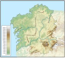
The Galician Massif is a system of mountain ranges in the northwestern corner of the Iberian Peninsula. It is located in Galicia with its southeastern end reaching into the provinces of Zamora and León of Castile and León. Its highest point is Pena Trevinca at 2,127 metres (6,978 ft). Another important peak is Cabeza de Manzaneda.
The Galician Regionalist Association was an active regionalist political organization in Galicia between 1890 and 1892.

Galician Coalition is a political party in Galiza with a Galician nationalist and centrist ideology. Since 2012 CG is part of the coalition Compromiso por Galicia.

The topographical relief of Spain is characterized by being quite high, with an average altitude of 660 meters above sea level, quite mountainous compared to other European countries and only surpassed by Switzerland, Austria, Greece and the microstates of Andorra and Liechtenstein. In peninsular Spain, the terrain is articulated around a large Meseta Central that occupies most of the center of the Iberian Peninsula. Outside the plateau, there is the depression of the Guadalquivir river, located in the southwest of the peninsula, and the Ebro river depression, located in the northeast.