Related Research Articles

Mount Baker, also known as Koma Kulshan or simply Kulshan, is a 10,781 ft (3,286 m) active glacier-covered andesitic stratovolcano in the Cascade Volcanic Arc and the North Cascades of Washington in the United States. Mount Baker has the second-most thermally active crater in the Cascade Range after Mount St. Helens. About 30 miles (48 km) due east of the city of Bellingham, Whatcom County, Mount Baker is the youngest volcano in the Mount Baker volcanic field. While volcanism has persisted here for some 1.5 million years, the current volcanic cone is likely no more than 140,000 years old, and possibly no older than 80–90,000 years. Older volcanic edifices have mostly eroded away due to glaciation.

Bellingham is the most populous city in, and county seat of Whatcom County in the U.S. state of Washington. It lies 21 miles (34 km) south of the U.S.–Canada border and in between Vancouver, British Columbia and Seattle.

Long Valley Caldera is a depression in eastern California that is adjacent to Mammoth Mountain. The valley is one of the Earth's largest calderas, measuring about 20 mi (32 km) long (east-west), 11 mi (18 km) wide (north-south), and up to 3,000 ft (910 m) deep.

Whatcom County is a county located in the northwestern corner of the U.S. state of Washington, bordered by the Lower Mainland of British Columbia to the north, Okanogan County to the east, Skagit County to the south, San Juan County across Rosario Strait to the southwest, and the Strait of Georgia to the west. Its county seat and largest population center is the coastal city of Bellingham, comprising the Bellingham, WA Metropolitan Statistical Area, and as of the 2020 census, the county's population was 226,847.

Western Washington University is a public university in Bellingham, Washington. The northernmost university in the contiguous United States, WWU was founded in 1893 as the state-funded New Whatcom Normal School, succeeding a private school of teaching for women founded in 1886. In 1977, the university adopted its present name.

Point Roberts is a pene-exclave of Washington on the southernmost tip of the Tsawwassen peninsula, south of Vancouver, British Columbia. The area, which had a population of 1,191 at the 2020 census, is reached by land from the rest of the United States by traveling 25 mi (40 km) through Canada. It is a census-designated place in Whatcom County, Washington, with a post office, and a ZIP Code of 98281. Direct sea and air connections with the rest of the U.S. are available across Boundary Bay.

Owens Valley is an arid valley of the Owens River in eastern California in the United States. It is located to the east of the Sierra Nevada, west of the White Mountains and Inyo Mountains, and is within the northern end of the Mojave Desert. It sits on the west edge of the Great Basin. The mountain peaks on the West side reach above 14,000 feet (4,300 m) in elevation, while the floor of the Owens Valley is about 4,000 feet (1,200 m), making the valley the deepest in the United States. The Sierra Nevada casts the valley in a rain shadow, which makes Owens Valley "the Land of Little Rain". The bed of Owens Lake, now a predominantly dry endorheic alkali flat, sits on the southern end of the valley.

The 1872 Owens Valley earthquake – also known as the Lone Pine earthquake – struck on March 26 at 02:30 local time in the Owens Valley, with the epicenter near the town of Lone Pine. Its magnitude has been estimated at Mw 7.4 to 7.9, with a maximum Mercalli Intensity of X (Extreme). It was one of the largest earthquakes to hit California in recorded history and was similar in size to the 1906 San Francisco earthquake. Twenty-seven people were killed and fifty-six were injured.

The following is a bibliography of the Sierra Nevada of California, United States, including books on recreation, natural history, and human history.
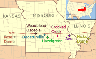
The 38th parallel structures, also known as the 38th parallel lineament, are a series of seven circular depressions or deformations stretching 700 kilometres (430 mi) across southern Illinois and Missouri and into eastern Kansas, in the United States, at a latitude of roughly 38 degrees north. Estimated at 300 million years old, two are believed to be impact events from meteorites, but other structures are possibly remnants of volcanos.

The Kaibab Limestone is a resistant cliff-forming, Permian geologic formation that crops out across the U.S. states of northern Arizona, southern Utah, east central Nevada and southeast California. It is also known as the Kaibab Formation in Arizona, Nevada, and Utah. The Kaibab Limestone forms the rim of the Grand Canyon. In the Big Maria Mountains, California, the Kaibab Limestone is highly metamorphosed and known as the Kaibab Marble.

Larrabee State Park is a public recreation area located on Samish Bay on the western side of Chuckanut Mountain, 6 mi (9.7 km) south of the city of Bellingham, Washington. It was created in 1915 as Washington's first state park. The park covers 2,748 acres (1,112 ha) and features fishing, boating, and camping as well as mountain trails for hiking and biking. It is managed by the Washington State Parks and Recreation Commission.

The Fossil Falls is a unique geological feature, located in the Coso Range of California in the United States. Volcanic activity in the mountain range, along with meltwater from glaciers in the nearby Sierra Nevada, played a role in the creation of the falls. They are located near the community of Little Lake, 1.0 mi (1.6 km) off US 395 on Cinder Road to Red Hill, with signs to Fossil Falls.

The Redwall Limestone is a resistant cliff-forming unit of Mississippian age that forms prominent, red-stained cliffs in the Grand Canyon, ranging in height from 500 feet (150 m) to 800 feet (240 m).
David Samuel Tucker is a geologist, author, and union organizer in Washington state. He is a research associate at Western Washington University. He was an instructor at North Cascades Institute, and the director of the Mount Baker Volcano Research Center. He writes the blog Northwest Geology Field Trips, a blog aimed at laypeople detailing where to find interesting geology in the Pacific Northwest. In 2015, he published a popular book on Washington geology, Geology Underfoot in Western Washington. He resides in Bellingham, Washington. In the 1980s he worked as a mountaineering guide in the Cascades, Mexico, and South America.
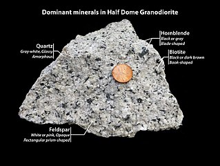
Half Dome Granodiorite is granodiorite found in a region on and near Half Dome, in Yosemite National Park, California, United States. The granodiorite forms part of the Tuolumne Intrusive Suite, one of the four major intrusive suites within the Sierra Nevada.

El Capitan Granite is a type of granite, in a large area near El Capitan, in Yosemite National Park, California, United States. The granite forms part of the Tuolumne Intrusive Suite, one of the four major intrusive suites within the Sierra Nevada.
Kuna Crest Granodiorite, is found, in Yosemite National Park, United States. The granodiorite forms part of the Tuolumne Intrusive Suite, one of the four major intrusive suites within the Sierra Nevada. Of the Tuolumne Intrusive Suite, it is the oldest and darkest rock.
An intrusive suite is a group of plutons related in time and space. All rocks in an intrusive suite result from the same magma-producing event.

Johnson Peak is the highest mountain, in Tuolumne Meadows, Yosemite National Park.
References
- ↑ "Geology Underfoot". Mountain Press . Retrieved 2023-02-02.
- ↑ "Geology Underfoot Series | NHBS Academic & Professional Books". www.nhbs.com. Retrieved 2023-02-03.
- ↑ "Orndorf, [sic] Richard L." Mountain Press. Retrieved 2023-02-03.
- ↑ Cook, Robert B. (2016-01-02). "Geology Underfoot in Western Washington by Dave Tucker. Mountain Press Publishing, www.mountain-press.com. 388 pages; 2015; $24 plus shipping and handling (softbound)". Rocks & Minerals. 91 (1): 89–90. doi:10.1080/00357529.2016.1101795. ISSN 0035-7529. S2CID 130250421.
- ↑ Multiple sources:
- "BOOKS: Learn about local geology with Dave Tucker on May 11". The Bellingham Herald . May 10, 2015.
- "Western geologist speaks on launch of new book". The Front. May 15, 2015.
- Kahn, Dean (June 10, 2015). "Bellingham geologist writes Western Washington guidebook". The Bellingham Herald .
- Bentley, Callan (2015-08-17). "Geology Underfoot in Western Washington, by Dave Tucker". Mountain Beltway. Retrieved 2023-04-21.
- ↑ Tucker, David (2015-11-05). "Writing a People's Natural History Guidebook: Geology Underfoot in Western Washington". Speaking of Maps Lectures.
- ↑ Geology Underfoot in Western Washington. City of Bellingham, Washington. Apr 14, 2016 [Presented Apr 14, 2016; posted April 18, 2016] – via YouTube.
- ↑ "Geology Underfoot in Western Washington". WhatcomTalk. Retrieved 2023-04-21.
- ↑ "Friday, July 24th, 7:00pm -- Dave Tucker, Author of "Geology Underfoot in Western Washington"". Orca Books.
- ↑ Cook, Robert B. (2012-01-31). "Media Review: Geology Underfoot in Northern Arizona". Rocks & Minerals. 87 (1): 83–84. doi:10.1080/00357529.2012.635920. ISSN 0035-7529. S2CID 128563657.
- ↑ QUARTAROLI, RICHARD D. (2009). "Review of GEOLOGY UNDERFOOT IN NORTHERN ARIZONA". The Journal of Arizona History. 50 (1): 83. ISSN 0021-9053. JSTOR 41697549.
- ↑ "Geology Underfoot". The Current. Retrieved 2023-04-21.
- ↑ "Roadside Geology Series - Geology Underfoot". geology.com. Retrieved 2023-02-03.