Geology of Taranaki

Last updated

The Taranaki Region of New Zealand is built upon the Median Batholith in the West, and Greywacke Rocks in the East. However, no rocks older than Miocene times are visible at the surface. The dominant feature of the Taranaki Region is the andesitic stratovolcano of Mount Taranaki, which is only about 130,000 years old. The dissected hill country to the East of the Taranaki Peninsula, and West of the Central Volcanic Plateau (Ruapehu and Tongariro) is composed of soft Miocene to Pleistocene sandstone and mudstone. The coastal lowlands around Wanganui to the South have well-developed Quaternary marine terraces, and coastal sand dunes.

Contents

The Taranaki Basin is the only area in New Zealand with significant known oil and gas deposits, many of them offshore.

Basement rocks

Basement rocks do not outcrop in the Taranaki Region due to the thick sedimentary and volcanic cover. However, the basement rocks have been inferred through exploration drilling, geophysical surveys and extrapolation from neighbouring regions. The Median Batholith lies to the West of a line between New Plymouth and Manaia. To the East of this line are, in order, the Brook Street, Murihiku, Dun Mountain-Maitai, Caples, Waipapa (Morrinsville), and Torlesse (Kaweka) Terranes, mostly composed of Greywacke (apart from the ophiolitic Dun Mountain-Maitai Terrane).

Te Kuiti Group Coal and Limestone

Throughout much of the West of the North Island, rocks containing coal were formed from swampland in Late Eocene times (37-34 Ma). The land sunk and the sea transgressed, and calcareous sandstone, mudstone, and limestone were deposited in Oligocene times (34-24 Ma). These rocks underlie more recent Miocene rocks, around the Taranaki Peninsula and surrounding seas. The Eocene rocks often provide oil and gas deposits of the Taranaki Region. Mudstone anticlines often provide a suitable sealing cover.

Miocene to Recent Sediment

In early Miocene times (24 Ma), plate convergence caused regional compression. Since then, sedimentation has occurred throughout the Taranaki Region, generating sandstones, soft mudstones, and some limestone.

The coastal lowlands around Wanganui have well-developed Quaternary marine terraces (caused by sea-level fluctuations and tectonic uplift), and coastal sand dunes.

Mohakatino Volcanic Arc

The volcanic arc that developed to the West of Northland and Auckland in Miocene times (23 Ma) extended further South towards Taranaki. These andesitic and basaltic volcanoes were mostly active in middle Miocene times (14-11 Ma), but some were still active in late Miocene times (5 Ma). They have all eroded away.

Recent volcanic activity

Several largely andesitic volcanoes have erupted in Taranaki in the last two million years. They align in a northwest–southeast direction, generally getting younger to the Southeast. Mount Taranaki, the most recent, remains potentially active.

The volcanic plugs, Paritutu, forming part of New Plymouth's harbour, and the Sugar Loaf Islands, offshore from New Plymouth, represent the remnants of a large volcano that erupted 1.8 Ma ago.

Kaitake, near the coast to the Northwest of Mount Taranaki, erupted 0.6 Ma ago.

Pouakai, on the Northwest side of Mount Taranaki, erupted around 255,000-215,000 years ago.

Pukeiti is probably around 17,000 years old.

View of Mount Taranaki from Stratford, facing west. Fanthams Peak is to the left of the main peak. Mt Taranaki.JPG
View of Mount Taranaki from Stratford, facing west. Fanthams Peak is to the left of the main peak.

Mount Taranaki, together with its parasitic cone of Fanthams Peak, dominates the topography of the Taranaki Peninsula. The ancestral Taranaki volcano has probably existed for at least 130,000 years, repeatedly forming and collapsing over its history. The lava around Dawson Falls has been dated as 18,000 years old. The lava flows that formed the upper cone have been dated as no older than 7,000 years. Fanthams Peak has lava flows dated as 3,200 years old. The lava forming the dome of Mount Taranaki was emplaced in 1755 CE.

The Central Volcanic Plateau (notably Mounts Ruapehu and Tongariro), is also active. The main effects of eruptions from this area on the Taranaki Region involve the generation of lahars flowing down the Whangaehu River (from Ruapehu), and the Whanganui River (from both Ruapehu and Tongariro).

Geological Resources

The Taranaki Peninsula and surrounding sea provides New Zealand with its only known commercial oil and gas fields, including Kapuni, Maui, and Pohokura (see also Oil and gas industry in New Zealand). The rocks above the deposits have an appropriate shape, and are of a suitable composition to create a seal, and trap the oil and gas as it migrates up towards the surface. The continental shelf West of the Taranaki Peninsula is shallow, making it easy to drill for oil and gas.

The Taranaki Region is well known for its black sand, which is mined for iron and other products.

Geological Sites Worth Visiting

Maps

Geological maps of New Zealand can be obtained from the New Zealand Institute of Geological and Nuclear Science (GNS Science), a New Zealand Government Research Institute. [1]

GNS provides a free Map of New Zealand's Geological Foundations. [2]

The main maps are the 1 : 250 000 QMap series, which will be completed as a series of 21 maps in 2010.[ needs update ] Low resolution versions of these maps (without the associated booklet) can be downloaded from the GNS site for free. [3] The map for the Taranaki Area was published in 2008. [4]

See also

Related Research Articles

<span class="mw-page-title-main">Mount Ruapehu</span> Active stratovolcano at the south of the North Island of New Zealand

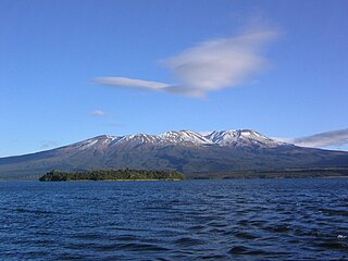
Mount Ruapehu is an active stratovolcano at the southern end of the Taupō Volcanic Zone and North Island volcanic plateau in New Zealand. It is 23 km (14 mi) northeast of Ohakune and 23 km (14 mi) southwest of the southern shore of Lake Taupō, within the Tongariro National Park. The North Island's major ski resorts and only glaciers are on its slopes.

<span class="mw-page-title-main">Taupō Volcanic Zone</span> Active volcanic zone in New Zealand

The Taupō Volcanic Zone (TVZ) is a volcanic area in the North Island of New Zealand that has been active for the past two million years and is still highly active. Mount Ruapehu marks its south-western end and the zone runs north-eastward through the Taupō and Rotorua areas and offshore into the Bay of Plenty. It is part of the larger Central Volcanic Region that extends further westward through the western Bay of Plenty to the eastern side of the Coromandel Peninsula and has been active for four million years. At Taupō the rift volcanic zone is widening east–west at the rate of about 8 mm per year while at Mount Ruapehu it is only 2–4 mm per year but this increases at the north eastern end at the Bay of Plenty coast to 10–15 mm per year. It is named after Lake Taupō, the flooded caldera of the largest volcano in the zone, the Taupō Volcano and contains a large central volcanic plateau as well as other landforms associated with its containing tectonic intra-arc continental Taupō Rift.

<span class="mw-page-title-main">Mount Taranaki</span> Volcano in North Island of New Zealand

Mount Taranaki (Māori: Taranaki Maunga; is a dormant stratovolcano in the Taranaki region on the west coast of New Zealand's North Island. At 2,518 metres, it is the second highest mountain in the North Island, after Mount Ruapehu. It has a secondary cone, Fanthams Peak, 1,966 metres, on its south side.

<span class="mw-page-title-main">Geology of Great Britain</span> Overview of the geology of Great Britain

The geology of Great Britain is renowned for its diversity. As a result of its eventful geological history, Great Britain shows a rich variety of landscapes across the constituent countries of England, Wales and Scotland. Rocks of almost all geological ages are represented at outcrop, from the Archaean onwards.

<span class="mw-page-title-main">Mount Ngauruhoe</span> Active volcano in New Zealand

Mount Ngauruhoe is a volcanic cone in New Zealand. It is the youngest vent in the Tongariro stratovolcano complex on the Central Plateau of the North Island and first erupted about 2,500 years ago. Although often regarded as a separate mountain, geologically, it is a secondary cone of Mount Tongariro.

<span class="mw-page-title-main">Mount Tongariro</span> Compound Volcano in New Zealand

Mount Tongariro is a compound volcano in the Taupō Volcanic Zone of the North Island of New Zealand. It is located 20 km (12 mi) to the southwest of Lake Taupō, and is the northernmost of the three active volcanoes that dominate the landscape of the central North Island.

The Tongariro Alpine Crossing in Tongariro National Park is a tramping track in New Zealand, and is among the most popular day hikes in the country. The Tongariro National Park is a World Heritage site which has the distinction of dual status, as it has been acknowledged for both its natural and cultural significance.

<span class="mw-page-title-main">Volcanism of New Zealand</span> Volcanic activity of New Zealand

The volcanism of New Zealand has been responsible for many of the country's geographical features, especially in the North Island and the country's outlying islands.

<span class="mw-page-title-main">Achilles Point</span>

Achilles Point is a rocky point on the headland at the eastern end of the small sandy beach named Ladies Bay, Auckland, New Zealand. The name 'Te Pane o Horoiwi' can also sometimes refer to the whole headland between St Heliers and Tamaki River estuary. Achilles Point is named after a ship called HMNZS Achilles (70) which defeated the German pocket battleship Admiral Graf Spee in 1939. The headland, from the point round to the Tamaki heads, was previously known as Te Pane o Horoiwi, named after Horoiwi who arrived in New Zealand on the Tainui canoe (waka).

<span class="mw-page-title-main">Geology of New Zealand</span> Overview of the geology of New Zealand

The geology of New Zealand is noted for its volcanic activity, earthquakes and geothermal areas because of its position on the boundary of the Australian Plate and Pacific Plates. New Zealand is part of Zealandia, a microcontinent nearly half the size of Australia that broke away from the Gondwanan supercontinent about 83 million years ago. New Zealand's early separation from other landmasses and subsequent evolution have created a unique fossil record and modern ecology.

<span class="mw-page-title-main">Geology of the Auckland Region</span>

The Auckland Region of New Zealand is built on a basement of greywacke rocks that form many of the islands in the Hauraki Gulf, the Hunua Ranges, and land south of Port Waikato. The Waitākere Ranges in the west are the remains of a large andesitic volcano, and Great Barrier Island was formed by the northern end of the Coromandel Volcanic Zone. The Auckland isthmus and North Shore are composed of Waitemata sandstone and mudstone, and portions of the Northland Allochthon extend as far south as Albany. Little Barrier Island was formed by a relatively isolated andesitic volcano, active around 1 to 3 million years ago.

The Waikato and King Country regions of New Zealand are built upon a basement of greywacke rocks, which form many of the hills. Much of the land to the west of the Waikato River and in the King Country to the south has been covered by limestone and sandstone, forming bluffs and a karst landscape. The volcanic cones of Karioi and Pirongia dominate the landscape near Raglan and Kawhia Harbours. To the east, the land has been covered with ignimbrite deposits from the Taupo Volcanic Zone. Large amounts of pumice from the Taupo Volcanic Zone have been deposited in the Waikato Basin and Hauraki Plains.

The Wellington Region of New Zealand has a foundation of Torlesse Greywacke rocks, that make up the Tararua and Rimutaka Ranges, that go from Wellington in the south to the Manawatu Gorge, where they are renamed as the Ruahine Ranges, and continue further north-northeast, towards East Cape. To the west of the Tararua Ranges are the Manawatu coastal plains. To the east of the Ruahine Ranges is the Wairarapa-Masterton Basin, then the Eastern Uplands that border the eastern coast of the North Island from Cape Palliser to Napier.

The Raukumara Region of New Zealand corresponds to the East Cape of the North Island, and associated mountain ranges.

<span class="mw-page-title-main">Geology of the Canterbury Region</span> Overview of the geology of Canterbury, New Zealand

Canterbury in New Zealand is the portion of the South Island to the east of the Southern Alps / Kā Tiritiri o te Moana, from the Waiau Uwha River in the north, to the Waitaki River in the south.

<span class="mw-page-title-main">Geology of the Northland Region</span>

New Zealand's Northland Region is built upon a basement consisting mainly of greywacke rocks, which are exposed on the eastern side of the peninsula. In-place Eocene coal measures crop out at Kamo, near Whangarei, and Oligocene limestone crops out at Hikurangi, near Whangarei.

<span class="mw-page-title-main">Geology of the Tasman District</span>

The Tasman Region, and the small adjoining Nelson Region, form one of the more geologically interesting regions of New Zealand. It contains the oldest rocks of anywhere on New Zealand's main islands. It contains all the main terranes that make up New Zealand's basement. These basement rocks include Ultramafic rocks, such as Serpentine and Dunite, and valuable minerals, such as Gold. The Nelson Region is bordered to the south by the Alpine Fault, the main fault forming the boundary between the Pacific Plate and the Indo-Australian Plate, that generated the Southern Alps.

<span class="mw-page-title-main">Taranaki Basin</span> Onshore-offshore Cretaceous rift basin on the West Coast of New Zealand

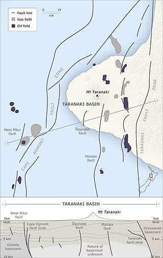
The Taranaki Basin is an onshore-offshore Cretaceous rift basin on the West Coast of New Zealand. Development of rifting was the result of extensional stresses during the breakup of Gondwanaland. The basin later underwent fore-arc and intra-arc basin development, due to the subduction of the Pacific Plate under the Australian Plate at the Hikurangi Subduction System. The basin covers approximately 100,000 km2 of which the majority is offshore. The basin contains mostly marine sediment, with significant terrestrial sediment from the Late Cretaceous to the Eocene. The majority of New Zealand's oil and gas production occurs within the basin, with over 400 wells and approximately 20 oil and gas fields being drilled.

Kapuni is an onshore natural gas-condensate field located in the Taranaki Basin, a ~100,000 km2 partially-inverted rift basin on the Taranaki Peninsula in the North Island, New Zealand. Discovered in 1959 and brought into production in 1970, Kapuni remained New Zealand's only producing gas-condensate field until the offshore Maui gas field began production in 1979.

Much of the volcanic activity in the northern portions of the North Island of New Zealand is recent in geological terms and has taken place over the last 30 million years. This is primarily due to the North Island's position on the boundary between the Indo-Australian and Pacific Plates, a part of the Pacific Ring of Fire, and particularly the subduction of the Pacific Plate under the Indo-Australian Plate. The activity has included some of the world's largest eruptions in geologically recent times and has resulted in much of the surface formations of the North Island being volcanic as shown in the map.

References

  1. New Zealand Institute of Geological and Nuclear Sciences (GNS Science) - a New Zealand government Crown Research Institute.
  2. "GNS Map of New Zealand's Geological Foundations" (PDF). Archived from the original (PDF) on 2010-05-22. Retrieved 2009-08-10.
  3. GNS New Zealand Geological Maps Archived 2009-10-08 at the Wayback Machine .
  4. "Geology of the Taranaki Area,Townsend, D., Vonk, A., Kamp, P.J.J. , GNS Science, 2008. (1 : 250 000 map)". Archived from the original on 2009-10-09. Retrieved 2009-08-15.

Further reading