State Route 233 | ||||
---|---|---|---|---|
Route information | ||||
Maintained by GDOT | ||||
Length | 19.4 mi [1] (31.2 km) | |||
Existed | 1944 [2] [3] –present | |||
Major junctions | ||||
South end | ||||
North end | ||||
Location | ||||
Counties | Ben Hill, Wilcox | |||
Highway system | ||||
|
State Route 233 (SR 233) is a 19.4-mile-long (31.2 km) north–south state highway in the central part of the U.S. state of Georgia. It travels through portions of Ben Hill and Wilcox counties.
Central Georgia is the area containing the metropolitan region surrounding the city of Macon, in Bibb County in the U.S. state of Georgia. It abuts the Atlanta metropolitan area, just to the north.
Georgia is a state in the Southeastern United States. It began as a British colony in 1733, the last and southernmost of the original Thirteen Colonies to be established. Named after King George II of Great Britain, the Province of Georgia covered the area from South Carolina south to Spanish Florida and west to French Louisiana at the Mississippi River. Georgia was the fourth state to ratify the United States Constitution, on January 2, 1788. In 1802–1804, western Georgia was split to the Mississippi Territory, which later split to form Alabama with part of former West Florida in 1819. Georgia declared its secession from the Union on January 19, 1861, and was one of the original seven Confederate states. It was the last state to be restored to the Union, on July 15, 1870. Georgia is the 24th largest and the 8th most populous of the 50 United States. From 2007 to 2008, 14 of Georgia's counties ranked among the nation's 100 fastest-growing, second only to Texas. Georgia is known as the Peach State and the Empire State of the South. Atlanta, the state's capital and most populous city, has been named a global city. Atlanta's metropolitan area contains about 55% of the population of the entire state.
Ben Hill County is a county located in the U.S. state of Georgia. As of the 2010 census, the population was 17,634. The county seat is Fitzgerald. The county was organized in 1906. It is named after Benjamin Harvey Hill, a former Confederate and United States Senator.
SR 233 begins at an intersection with SR 90 (Salem Church Road), northeast of Rebecca in northwestern Ben Hill County. About 1.2 miles (1.9 km), it crosses into Wilcox County. A short distance later, it intersects Reeves Farm Road (Wilcox County Road 124), J.D. Fitzgerald Road (Wilcox CR 119), and J.B. McWorther Road (Wilcox CR 60) in rapid succession, before it intersects Owensboro Road, which leads to Abbeville. Shortly after is Taylor Road (Wilcox CR 128) and Smitty Road (Wilcox CR 68). Just after this, the route begins heading northwest, intersecting Hudson Road (Wilcox CR 131), Nelson Keene Road (Wilcox CR 115), Crawford Road (Wilcox CR 61), and later, County Farm Road (Wilcox CR 62)/East County Farm Road. Just before entering Rochelle, SR 233 intersects SR 112; they share a concurrency through the city. In Rochelle, the two routes pass local roads that provide access to Wilcox Elementary School and Donnie Clack Stadium. In downtown, they intersect SR 215 (5th Avenue). The three highways share a very brief concurrency in town. About 5 blocks later, they intersect US 280/SR 30 (1st Avenue), where SR 215 departs to the west. SR 112/SR 233 depart Rochelle to the north, passing Hawkins Road (Wilcox CR 26) before splitting. To the northeast, it intersects Brown Water Road (Wilcox CR 7), Bruce Road (Wilcox CR 36), Hackett Road (Wilcox CR 50), Barker Road (Wilcox CR 49), McDuffie Road (Wilcox CR 48), all in rapid succession. Then, it passes Helms Road (Wilcox CR 9), Matthews Road (Wilcox CR 10), McGlamry Road (Wilcox CR 302), before reaching Cannonsville Road (Wilcox CR 253, which leads to Abbeville and Pineview). Farther to the northeast is Dix Road (Wilcox CR 218) and Jean Arthur Road (Wilcox CR 216), and then Connor Road (Wilcox CR 33), before reaching its northern terminus, an intersection with US 129/SR 11 in the northeastern part of Wilcox County. [1]
An intersection is an at-grade junction where two or more roads meet or cross. Intersections may be classified by number of road segments, traffic controls, and/or lane design.
State Route 90 (SR 90) is a 155-mile-long (249 km) state highway that runs southeast-to-northwest through portions of Atkinson, Coffee, Irwin, Ben Hill, Turner, Wilcox, Crisp, Dooly, Macon, Taylor, and Talbot counties in the south-central and west-central parts of the U.S. state of Georgia. The route connects Willacoochee and Talbotton, via Fitzgerald and Ocilla.
Rebecca is a city in Turner County, Georgia, United States, along the Alapaha River. The population was 246 at the 2000 census.
No section of SR 223 is part of the National Highway System, a system of routes determined to be the most important for the nation's economy, mobility and defense. [4]
The National Highway System (NHS) is a network of strategic highways within the United States, including the Interstate Highway System and other roads serving major airports, ports, rail or truck terminals, railway stations, pipeline terminals and other strategic transport facilities. Altogether, it constitutes the largest highway system in the world.
The 1944 GDOT map showed that SR 233 was established in 1944 along the same alignment as it runs today, with the portion concurrent with SR 112 being paved. [2] [3] However, the 1946 GDOT map showed that the paved section was only the section from an undetermined point in Rochelle to the northern intersection with SR 112. [5] [6] By 1952, a short section just south of Rochelle was paved. [7] [8] By 1961, the road was paved from its southern terminus to its northern intersection with SR 112. [9] [10] By 1964, the road was paved the rest of its length. [11] [12]
County | Location | mi [1] | km | Destinations | Notes |
---|---|---|---|---|---|
Ben Hill | | 0.0 | 0.0 | Southern terminus | |
Wilcox | | 7.8 | 12.6 | Southern end of SR 112 concurrency | |
Rochelle | 8.4 | 13.5 | Southern end of SR 215 concurrency | ||
8.8 | 14.2 | Northern end of SR 215 concurrency | |||
| 10.5 | 16.9 | Northern end of SR 112 concurrency | ||
| 19.4 | 31.2 | Northern terminus | ||
1.000 mi = 1.609 km; 1.000 km = 0.621 mi
|
Interstate 985 (I-985) is a 25.01-mile-long (40.25 km) Auxiliary Interstate Highway in the northeastern part of the U.S. state of Georgia. It links the Atlanta metropolitan area to the city of Gainesville via Suwanee. I-985 is also known as the Sidney Lanier Parkway and is also designated as unsigned State Route 419. The roadway was designated as I-985 in 1985.
State Route 300, is a 107-mile-long (172 km) state highway in the southern part of the U.S. state of Georgia. Its southern terminus is at the Florida state line south-southeast of Thomasville, where the roadway continues as US 19/SR 57. This is also the southern terminus of SR 3, with which US 19 and SR 300 travel concurrently through the southern part of the state. Its northern terminus is at Interstate 75 (I-75) in Cordele.
State Route 255 (SR 255) is a 19.7-mile-long (31.7 km) S-shaped state highway located in the North Georgia mountains section of the U.S. state of Georgia. It travels through White and Habersham counties.
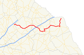
State Route 51 (SR 51) is a 63.6-mile-long (102.4 km) state highway that travels west-to-east through portions of Hall, Banks, Franklin, and Hart counties in the northeastern part of the U.S. state of Georgia. The highway connects Lula with Lake Hartwell, via Homer, Carnesville, and Hartwell.
State Route 272 (SR 272) is a 15.4-mile-long (24.8 km) north–south state highway located in the east-central part of the U.S. state of Georgia. Its path is entirely within Washington County.
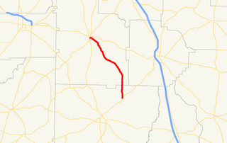
State Route 271 (SR 271) is a 7.6-mile-long (12.2 km) east–west state highway located in the west-central part of the U.S. state of Georgia. Its route is within Schley and Sumter counties.
State Route 268 (SR 268) is a 22.9-mile-long (36.9 km) southwest–northeast state highway located in the south-central part of the U.S. state of Georgia. It travels within portions of Coffee and Jeff Davis counties.
State Route 266 (SR 266) is a 18.2-mile-long (29.3 km) east–west state highway located in the southwestern part of the U.S. state of Georgia. Its path is within Clay and Randolph counties.
State Route 264 (SR 264) is a 2.7-mile-long (4.3 km) northwest-southeast state highway located in the eastern part of the Atlanta metropolitan area in the U.S. state of Georgia. Its route is entirely within Gwinnett County.
State Route 262 (SR 262) is a 44.4-mile-long (71.5 km) L-shaped state highway located in the southwestern part of the U.S. state of Georgia. It travels within portions of within Decatur and Mitchell counties, and skims the border of Grady County.
State Route 256 (SR 256) is a 21.0-mile-long (33.8 km) north–south state highway located in the southern part of the U.S. state of Georgia. Its route is within Colquitt and Worth counties.
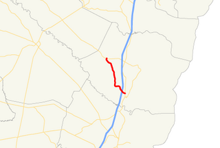
State Route 254 (SR 254) is a 10.8-mile-long (17.4 km) southwest-northeast state highway located in the northeastern part of the U.S. state of Georgia. It travels through portions of Hall and White counties.
State Route 251 (SR 251) is a 13.5-mile-long (21.7 km) south–north state highway located in the east-central part of the U.S. state of Georgia. It travels entirely within McIntosh County.
State Route 243 (SR 243) was a 21.2-mile-long (34.1 km) north–south state highway located in the central part of the U.S. state of Georgia. It existed in portions of Wilkinson and Baldwin counties.
State Route 242 (SR 242) is a 25.0-mile-long (40.2 km) east–west state highway located in the central part of the U.S. state of Georgia. It travels through portions of Washington and Jefferson counties.
State Route 240 (SR 240) is a 37.6-mile-long (60.5 km) southeast-northwest state highway located in the west-central part of the U.S. state of Georgia. It travels through portions of Macon, Schley, Marion, and Talbot counties.
State Route 234 (SR 234) is a 28.3-mile-long (45.5 km) east–west state highway located in the southwestern part of the U.S. state of Georgia. It travels through portions of Calhoun and Dougherty counties.
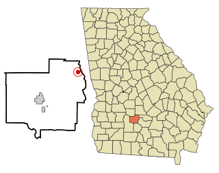
State Route 231 (SR 231) is a 20.6-mile-long (33.2 km) north-south state highway in the central part of the U.S. state of Georgia. It travels entirely within Washington County. It serves as a de facto bypass or alternate route for travelers who desired to bypass Sandersville.
U.S. Route 25 (US 25) is a U.S. Highway that travels from Brunswick, Georgia to the Kentucky-Ohio state line, where Covington, Kentucky meets Cincinnati, Ohio at the Ohio River. In the U.S. state of Georgia, US 25 is as a 190.0-mile-long (305.8 km) highway that travels south to north in the eastern part of the state, near the Atlantic Ocean, serving Brunswick, Statesboro, and Augusta on its path from Brunswick to South Carolina at the Savannah River. Its routing travels through portions of Glynn, Wayne, Long, Tattnall, Evans, Bulloch, Jenkins, Burke, and Richmond counties.
State Route 227 (SR 227) is a 2.2-mile-long (3.5 km) connecting state highway that travels south-to-north through portions of Treutlen County in the east-central part of the U.S. state of Georgia.
Route map:
KML file (edit • help) |