
Williston Lake is a reservoir created by the W. A. C. Bennett Dam and is located in the Northern Interior of British Columbia, Canada.
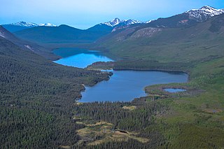
Chase Provincial Park is a provincial park in British Columbia, Canada, located around Carina and Tomias Lakes, 70 km north of Germansen Landing in the Omineca Mountains and just west of the Finlay Arm of Williston Lake. Approximately 36,226 hectares, it was established in 2001.
The Omineca Mountains, also known as "the Ominecas", are a group of remote mountain ranges in the Boreal Cordillera of north-central British Columbia, Canada. They are bounded by the Finlay River on the north, the Rocky Mountain Trench on the east, the Nation Lakes on the south, and the upper reaches of the Omineca River on the west. They form a section of the Continental Divide, that, in this region, separates water drainage between the Arctic and Pacific Oceans. The lower course of the Omineca River flows through the heart of the range. To the south of the Ominecas is the Nechako Plateau, to the west the Skeena Mountains and Hazelton Mountains, to the north the Spatsizi Plateau and the Stikine Ranges, while east across the Rocky Mountain Trench are the Muskwa Ranges.

Omineca River is a river of the North American boreal forest, in northern British Columbia, Canada. It flows into the Williston Lake, and is part of the Peace River basin. It was originally a tributary of the Finlay River before the creation of Lake Williston. According to Father Adrien-Gabriel Morice the name is derived from a Sekani word meaning 'lake-like or sluggish river'.
The Omineca Gold Rush was a gold rush in British Columbia, Canada in the Omineca region of the Northern Interior of the province. Gold was first discovered there in 1861, but the rush didn't begin until late in 1869 with the discovery at Vital Creek. There were several routes to the goldfields: two were from Fort St. James, one of which was a water route through the Stuart and Tachie Rivers to Trembleur Lake to Takla Lake and the other was overland, called the Baldy Mountain route. A third route came in overland from Hazelton on the Skeena River and a fourth route used the Fraser River and crossed over the Giscome Portage to Summit Lake, through McLeod Lake, and up the Finlay River to the Omineca River.
The Cassiar Country, also referred to simply as the Cassiar, is a historical geographic region of the Canadian province of British Columbia. The Cassiar is located in the northwest portion of British Columbia, just to the northeast of the Stikine Country, while to the south is the Omineca Country. The area is noted for the Cassiar gold rush of the 1870s, when Laketon became its unofficial capital. The ghost town of Cassiar is also located in the Cassiar region.
The Thumb is a mountain located 7 km (4 mi) south of Sitchiada Mountain on the east side of Bear Lake, on the divide between the upper Omineca River and the basin of the Bear River in the Omineca Country of the Central-North Interior of British Columbia, Canada. As the Omineca is part of the Arctic Ocean drainage, via the Peace and Mackenzie Rivers, and the Bear is in the basin of the Skeena River, which drains to the Pacific, The Thumb is located on the Continental Divide.
The Swannell Ranges are a mountain range between the Finlay and Nation Rivers and between the Hogem Ranges and the Finlay Ranges of northern British Columbia, Canada. It has an area of 22932 km2 and is a subrange of the Omineca Mountains which in turn form part of the Interior Mountains. They are named in honour of legendary surveyor/explorer Frank Swannell.
The Hogem Ranges are a group of mountain ranges in the northwest part of the Omineca Country of the North-Central Interior of British Columbia, Canada, located between Takla Lake (W) and the Omineca River (E) and from the Nation Lakes (SE) to the Sustut River (NW). The ranges have a collective area of 8868 km2 and is a subgrouping of the Omineca Mountains which in turn form part of the Interior Mountains.
Manson is a surname of Scottish origin.
Henry "Harry" McDame was a Bahamas-born prospector in the California and British Columbia gold rushes.
The Axelgold Range is a subrange of the Hogem Ranges of the Omineca Mountains, located between Ominicetla Creek and upper Omineca River in northern British Columbia, Canada.
The Connelly Range is a subrange of the Hogem Ranges of the Omineca Mountains, located between Bear Lake and the headwaters of the Omineca River in northern British Columbia, Canada. As the Omineca is in the Arctic Ocean drainage and Bear Lake that of the Pacific, the range is part of the Continental Divide. It includes a group of volcanic plugs, the largest of which is The Thumb.
The Germansen Range is a small subrange of the Swannell Ranges of the Omineca Mountains, bounded by Germansen Lake and South Germansen River northern British Columbia, Canada.
Takla Landing, also known as McLaing Landing is an unincorporated locality and former steamboat landing on the east side of Takla Lake in the Omineca Country of the Central Interior of British Columbia, Canada. In the days of the Omineca Gold Rush, Takla Landing was a port for steamboats connecting trails from Hazelton, British Columbia via Babine Lake to trails leading from Takla Landing eastwards to the area of the gold strikes in the lower Omineca River.
The Sustut River is a major tributary of the Skeena River in the north-central Interior of British Columbia, Canada. It forms the northwest boundary of the Hogem Ranges and flows southwest to meet the Skeena, north of Hazelton. Originally named the Bear Wallow River, its headwaters are at Sustut Lake, northwest of Germansen Landing.
The Germansen River, formerly Germansen Creek, is a major south tributary of the Omenica River in the Northern Interior of British Columbia, Canada. The settlement and former gold-rush centre of Germansens Landing is located at its confluence with the Omineca. Along its course is Germansen Lake at 55°41′45″N124°51′10″W, south of which is the Germansen Range and Mount Germansen.
Manson River is a river located in the Omineca Country region of British Columbia. It flows north into Manson Arm, Williston Lake. The river is located south of Germansen Landing. It was first known as Manson Creek and was discovered in 1871 by Robert Howell. The river has been mined using wing-damming, drifting and hydraulicking. Manson River has been mined by Europeans and Chinese.
Silver Creek is a creek located in the Omineca Country region of British Columbia. The creek flows from the south into the Omineca River approximately 35 miles west of Germansen Landing. The creek was discovered by Byrnes' "Peace River Prospecting Party" in 1869. Gold and silver have been recovered from the creek. The creek has been mined by Europeans and Chinese Miners.
Omineca Provincial Park and Protected Area is a provincial park and protected area located in the north-central interior of British Columbia, Canada. It was established on 11 April 2001 by BC Parks to protect provincially significant riparian and wetland habitats along the Omineca River.
