Germansen River

Last updated

Germansen River
Trailing and camping in Alaska (1909) (14596757959).jpg
James Germansen, 1909
Canada British Columbia relief location map.jpg
Red pog.svg
Location
CountryCanada
Province British Columbia
Region Omineca
Regional district Bulkley–Nechako
Physical characteristics
Source 
  location Rocky Mountain Trench
Mouth Omineca River
  coordinates
55°47′13″N124°41′59″W / 55.78694°N 124.69972°W / 55.78694; -124.69972
  elevation
690 m (2,260 ft)

The Germansen River (formerly a.k.a. Germansen Creek) [1] is in the Omineca region of central British Columbia, Canada. Flowing through Germansen Lake, the river is a major tributary of the Omenica River, which in turn enters Williston Lake. [2] Surrounded by the spread of the Swannell Ranges, [3] the lake is south of Plughat Mountain [4] and north of the Germansen Range, which contains Mount Germansen. [5]

Contents

Name origin

In July 1870, James Germansen discovered gold on the creek/river. [6] The earliest newspaper mention of the creek name is October 1870. [7]

During the Omineca Gold Rush of the 1860s, James was known as Old Hogem, which gave the name to a mining camp on the Omineca River, where he charged exorbitant prices at his general store. [8] In 1868, he was the first to travel from that part of the interior to Fort Simpson. [9]

River course

The Germansen River is part of the Rocky Mountain Trench, where glacial and alluvial deposits make up riverbeds. Multiple till units in this river suggest that several oscillations of the ice front occurred in this region during the advance phase of the LGP. [10] Some of the low lying benches and bars possess no overlaying boulder clay, whereas other bedrock benches are overlain with up to 3 metres (10 ft) of auriferous glacial gravels, topped by up to 23 metres (75 ft) of boulder clay. Rock outcrops are greenschist, silicified sericite, thinly bedded argillites, and serpentinite. [1]

The significant tributaries are the South Germansen River, [11] Horseshoe Creek, Little Slate Creek, Goodasany Creek [12] (formerly Mill Creek), Ah Lock Creek, [13] and Plug Hat Creek. The watershed of the river encompasses 22,918 hectares (56,630 acres). [14]

For the most part, the valley is about 76 metres (250 ft) deep and well timbered. The 3-kilometre (2 mi) southeasterly section downriver from the lake outlet is a wide valley in the mature stage of the cycle of erosion. The channel then turns sharply northeast to enter a rock canyon. Exiting the canyon, the river continues 7 kilometres (4.5 mi), before turning northwesterly to flow 13 kilometres (8 mi) to the mouth. After passing through another mature stage valley, a 4-kilometre (2.5 mi) canyon exists at Mill Creek. Beyond is the wide valley of the Omineca River. [15]

Rock canyon at the forks

Cutting in parallel through separate high walled canyons, the Germansen and South Germansen rivers join after covering 1,200 metres (0.75 mi) and 800 metres (0.50 mi) respectively. [15]

In the 1870s, a sawmill operated at the lower end of the canyon. [8]

In 1934, a dirt road was built northward from Fort St. James, which divided nearby into northwestward to the canyon area and southeastward to Manson Creek. [16] The road was graded in 1939, in preparation for gravelling the next year. [17] A passenger transit service operated on the Fort St. James–Germansen Landing route during the early 1940s, [18] mid-1950s, [19] and around 2000. [20] No public transit provider currently exists in the area.

Germansen Lake

The shore length is 43 kilometres (27 mi), the surface area is about 1,800 hectares (4,400 acres), [21] [22] and the elevation is 957 metres (3,140 ft) above sea level. [1] The Germansen Narrows (a.k.a. Gebhardt Arm) is at the western end of the lake. [23]

In 1949, the trail along the north side of the lake was upgraded to a road. [24]

In 1956, the operator of an IH TD-18 drowned when his caterpillar plunged into the lake. [25]

Four camping areas are found along the lakeshore, and Rainbow Cove (on the east side of the narrows) has a combination of open field sites and a few semi-private ones. [26]

Ferries and bridges

A passenger would pull the unattended log raft ferry by rope across the Germansen Narrows. [27] [28] In some form or other, the ferry existed over many decades [29] at the western end of the lake. [30]

In 1948–49, a large scow was placed on the lake to move mining equipment from the east to west end of the lake. [31] About this time, a rock-filled crib replaced the narrows ferry, which in turn was replaced by a king truss bridge in 1954–55. [32]

At one time, a bridge existed over the river at the lake outlet. [33]

Mining

The reported mining earnings for the 1871 season were $400,000, which had fallen to $32,000 for the general area in 1875. By the next year, the mining district was almost deserted. [6] Placer mining for gold has taken place almost continuously since that time by individuals and intermittently by companies. Some hard-rock mining has also occurred. Germansen Placers, established in 1931 and renamed as Germansen Mines in 1934, undertook hydraulic mining about 11 kilometres (7 mi) from the river mouth until 1943. Flumes and a ditches supplied water from the South Germansen River. [34] Another account mentions the source as 3 kilometres (2 mi) downstream from the lake, then along flumes over the South Germansen, before entering a ditch line excavated in 1901. [35]

Downstream and on Plughat Creek, Germansen Ventures, which operated 1937–1942, obtained water from the lake, 24 kilometres (15 mi) away. During 1946–1961, various individuals worked these pits. Prior to 1950, the estimated gold production for the entire Germansen River system totalled 515,851 to 750,776 grams (18,196 to 26,483 oz). In 1966, Grizzly Gold Mines operated a dredge on the river. In 2010, Westwing Enterprises conducted seismic surveys. [34]

Old Germansen

In 1871, a new town being constructed 5 kilometres (3 mi) southeast from the river mouth was to be called Omineca. [36] Instead, the place became known as Germansen. The 12–20 wooden cabins rested on the lower steep sides of the valley, which had been denuded by clearing, burning, and/or flushing. [6]

By 1927, only one couple inhabited the place. [1]

By 1937, a footbridge spanned the river just upstream. [15]

Germansen Landing

Germansen Landing lies at the confluence into the Omineca River. [37]

South Germansen River

From headwaters in the Germansen Range, the river flows northeastward to its mouth. [5] The watershed is 18,426 hectares (45,530 acres). [14]

Geological mapping was conducted on this river by Taiga Consultants in 1980 and Anaconda Canada Exploration in 1982. Angel Jade Mines surveyed hard-rock prospects in 2017. [38]

Maps

Footnotes

  1. 1 2 3 4 Minister of Mines annual report, 1927. library.ubc.ca (Report). pp. 171–172 (C158–159).
  2. "Germansen River (river)". BC Geographical Names .
  3. "Swannell Ranges". bivouac.com.
  4. "Plughat Mountain (mountain)". BC Geographical Names .
  5. 1 2 "Germansen Range". bivouac.com.
  6. 1 2 3 Howay, Frederic W. (1914). "British Columbia from the earliest times to the present. Illustrated. Volume II". library.ubc.ca. S.J. Clarke Publishing. pp. 426–429 (266–267).
  7. "Victoria Daily Standard". www.newspapers.com. 31 Oct 1870. p. 3.
  8. 1 2 Pattullo, Thomas Dufferin (1920). "Vanderhoof to Peace River, British Columbia, Canada". library.ubc.ca. William H. Cullin. p. 24 (22).
  9. Wessels, A (1910). "Trailing and Camping in Alaska". books.google.ca. University of Wisconsin. p. 317.
  10. Sacco, David A. (2012). Quaternary Geology in Part of the McLeod Lake Map-Area (NTS 093J), Central British Columbia (PDF). summit.sfu.ca (MSc). p. 42 (27).
  11. "South Germansen River (river)". BC Geographical Names .
  12. "Goodasany Creek (creek)". BC Geographical Names .
  13. "Ah Lock Creek (creek)". BC Geographical Names .
  14. 1 2 "Mackenzie Sustainable Forest Management Plan, 2011/12 Annual Report" (PDF). www.canfor.com. pp. 47–48.
  15. 1 2 3 BC Gov 1937, p. 6 (C4).
  16. "Prince George Citizen". pgnewspapers.pgpl.ca. 14 Jun 1934. p. 2.
  17. "Prince George Citizen". pgnewspapers.pgpl.ca. 26 Oct 1939. p. 1.
  18. "Vancouver Sun". www.newspapers.com. 12 Nov 1942. p. 10.
  19. "Vancouver Sun". www.newspapers.com. 27 Nov 1954. p. 59.
  20. "Caledonian Courier". www.newspapers.com. 29 Mar 2000. p. 7.
  21. "Germansen Lake Fishing Map". www.gpsnauticalcharts.com.
  22. "Germansen Lake". www.anglersatlas.com.
  23. "Gebhardt Arm (arm)". BC Geographical Names .
  24. Minister of Mines annual report, 1949. library.ubc.ca (Report). p. 251 (A239).
  25. "Prince George Citizen". pgnewspapers.pgpl.ca. 23 Jul 1956. p. 10.
  26. "Omineca Provincial Park RV Guide". www.outdoorsy.com.
  27. Commissioner of Land and Works annual report, 1902. library.ubc.ca (Report). p. F100.
  28. Clapp, Frank A. (1991). Ministry of Transportation and Highways, Lake and River Ferries. Ministry of Transportation and Highways. p. 6. ISBN   0-7726-1364-8.
  29. Minister of Public Works annual report, 1935–36. library.ubc.ca (Report). p. 99 (I91).
    Minister of Public Works annual report, 1939–40. library.ubc.ca (Report). p. 115 (P107).
    Minister of Public Works annual report, 1944–45. library.ubc.ca (Report). p. 114 (O103).
  30. Minister of Public Works annual report, 1947–48. library.ubc.ca (Report). p. 136 (N118).
  31. Minister of Public Works annual report, 1948–49. library.ubc.ca (Report). p. O38.
  32. Minister of Public Works annual report, 1954–55. library.ubc.ca (Report). p. K64.
  33. Gibson, T.H.; Ramsay, C.; Low, B. (Dec 1997). The Mackenzie Timber Supply Area, Archaeological Overview Assessment Final Report (PDF). www2.gov.bc.ca (Report). p. 50 (40).
  34. 1 2 "Minfile No 093N 054". minfile.gov.bc.ca.
  35. BC Gov 1937, p. 11 (C9).
  36. "Langley Advance". www.newspapers.com. 29 Jul 1971. p. 16.
  37. "Germansen Landing (community)". BC Geographical Names .
  38. "Minfile No 093N 055". minfile.gov.bc.ca.
  39. Minister of Mines annual report, 1924. library.ubc.ca (Report). p. 120.
  40. BC Gov 1937, p. 7 (C5).
  41. Minister of Mines annual report, 1938. library.ubc.ca (Report). p. 6 (C4).

Related Research Articles

Highway 16 is a highway in British Columbia, Canada. It is an important section of the Yellowhead Highway, a part of the Trans-Canada Highway that runs across Western Canada. The highway closely follows the path of the northern B.C. alignment of the Canadian National Railway (CN). The number "16" was first given to the highway in 1941, and originally, the route that the highway took was more to the north of today's highway, and it was not as long as it is now. Highway 16 originally ran from New Hazelton east to Aleza Lake. In 1947, Highway 16's western end was moved from New Hazelton to the coastal city of Prince Rupert, and in 1953, the highway was re-aligned to end at Prince George. In 1969, further alignment east into Yellowhead Pass was opened to traffic after being constructed up through 1968 and raised to all-weather standards in 1969. Highway 16's alignment on Haida Gwaii was commissioned in 1983 and is connected to the mainland segment via BC Ferries route #11.

<span class="mw-page-title-main">Terrace, British Columbia</span> City in British Columbia, Canada

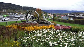
Terrace is a city in the Skeena region of west central British Columbia, Canada. This regional hub lies east of the confluence of the Kitsumkalum River into the Skeena River. On BC Highway 16, junctions branch northward for the Nisga'a Highway to the west and southward for the Stewart–Cassiar Highway to the east. The locality is by road about 204 kilometres (127 mi) southwest of Smithers and 144 kilometres (89 mi) east of Prince Rupert. Transportation links are the Northwest Regional Airport, a passenger train, and bus services.

<span class="mw-page-title-main">Hazelton, British Columbia</span> Village municipality in British Columbia, Canada

Hazelton is a village municipality in the Skeena region of west central British Columbia, Canada. The place is on the southeast side of the Skeena River immediately north of the Bulkley River mouth, where the confluence forms a peninsula. On BC Highway 62, the locality is by road about 75 kilometres (47 mi) northwest of Smithers and 144 kilometres (89 mi) northeast of Terrace. Hazelton is the original of the "Three Hazeltons", the other two being New Hazelton to the southeast and South Hazelton to the south.

<span class="mw-page-title-main">Usk, British Columbia</span> Hamlet in British Columbia, Canada

Usk is an unincorporated community in the Skeena region of west central British Columbia, Canada. The Usk Ferry connects the two parts of the hamlet that straddle the Skeena River. Just off BC Highway 16, the locality is by road about 182 kilometres (113 mi) west of Smithers and 23 kilometres (14 mi) northeast of Terrace.

Shalalth and South Shalalth are unincorporated communities on the northern shore near the western end of Seton Lake in the Squamish-Lillooet region of southwestern British Columbia. The localities are by road about 63 kilometres (39 mi) northwest of Lillooet, but only 24 kilometres (15 mi) by rail.

<span class="mw-page-title-main">Seton Lake</span> Lake in British Columbia, Canada

Seton Lake is a lake in the Squamish-Lillooet region of southwestern British Columbia. On the northeast side is Mission Ridge. On the southwest is the Cayoosh Range. By road, the eastern end is about 7 kilometres (4.3 mi) southwest of Lillooet.

<span class="mw-page-title-main">Alexandra Bridge Provincial Park</span> Provincial park in British Columbia, Canada

Alexandra Bridge Park lies within the lower Fraser Canyon of British Columbia, Canada. This provincial park is adjacent to the historic suspension bridge from 1926, which spans the Fraser River and was built using the eastern abutment of the bridge from 1863. The locality, on BC Highway 1, is by road about 44 kilometres (27 mi) north of Hope and 65 kilometres (40 mi) south of Lytton.

<span class="mw-page-title-main">Babine Lake</span> A large natural lake in British Columbia, Canada

Babine Lake borders the Skeena and Omineca regions of central British Columbia, Canada. Vehicle access to the lake, via BC Highway 16 and Nilkitkwa forestry service road, is by road about 105 kilometres (65 mi) northeast of Smithers; via BC Highway 16 and Central Babine Lake Highway, is about 132 kilometres (82 mi) east of Smithers; or via Babine Lake Road, is about 20 kilometres (12 mi) northeast of Burns Lake.

<span class="mw-page-title-main">Gitsegukla</span> Community in British Columbia, Canada

Gitsegukla is an unincorporated community in the Skeena region of west central British Columbia, Canada. The place is on the southeast side of the Skeena River adjacent to the Kitseguecla River mouth. On BC Highway 16, the locality is by road about 94 kilometres (58 mi) northwest of Smithers and 113 kilometres (70 mi) northeast of Terrace.

<span class="mw-page-title-main">Kitwanga</span> Place in British Columbia, Canada

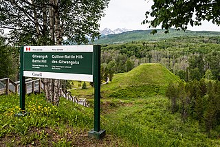
Kitwanga or Gitwangak is in the Skeena region of west central British Columbia. Among the Hazelton and Buckley Mountain Ranges, the place is on the north shore of the Skeena River, east of the Kitwanga River confluence. On BC Highway 37, northeast of the junction with BC Highway 16, the locality is by road about 115 kilometres (71 mi) northwest of Smithers, 99 kilometres (62 mi) northeast of Terrace, and 212 kilometres (132 mi) southeast of Stewart.

Alexandria or Fort Alexandria was a general area encompassing a trading post, ferry site, and steamboat landing in the North Cariboo region of central British Columbia. The present unincorporated community is on the eastern side of the Fraser River. On BC Highway 97, the locality is by road about 74 kilometres (46 mi) northwest of Williams Lake and 45 kilometres (28 mi) south of Quesnel.

Australian is an unincorporated community on the east side of the Fraser River in the North Cariboo region of central British Columbia. On BC Highway 97, the locality is by road about 85 kilometres (53 mi) north of Williams Lake and 33 kilometres (21 mi) south of Quesnel.

<span class="mw-page-title-main">Kitselas Canyon</span> Canyon in Kitimat-Stikine Regional District, Canada

Kitselas Canyon is a canyon carved by the Skeena River in the Skeena region of west central British Columbia, Canada. Off BC Highway 16, the landmark is by road about 185 kilometres (115 mi) west of Smithers and 20 kilometres (12 mi) northeast of Terrace.

Kitselas is a railway point on the northwestern shore of the Skeena River in the Skeena region of west central British Columbia, Canada. The former name was Vanarsdol. Across the Skeena to the southwest is the mouth of the Zymoetz River. This river bridge on BC Highway 16 is by road about 10 kilometres (6 mi) northeast of Terrace.

Cedarvale or Meanskinisht is an unincorporated community in the Skeena region of west central British Columbia. Concentrated on the southeastern shore of the Skeena River, no direct link exists to the portion on the northwestern shore. On BC Highway 16, the locality is by road about 130 kilometres (81 mi) northwest of Smithers and 75 kilometres (47 mi) northeast of Terrace.

Deserters Canyon is on the Finlay River in the Omineca region of central British Columbia, Canada. The canyon is just upstream (north) from the tip of the Finlay Arm on Lake Williston, the reservoir created by the W. A. C. Bennett Dam. By road along the west shore of the waterways, the locality is about 162 kilometres (101 mi) northwest of Finlay Forks and 523 kilometres (325 mi) northwest of Prince George.

Poplar Creek is a ghost town in the West Kootenay region of southeastern British Columbia. The former mining community is at the mouth of Poplar Creek on the southwest side of the Lardeau River. The locality, on BC Highway 31, is about 37 kilometres (23 mi) northwest of Lardeau and 16 kilometres (10 mi) southeast of Gerrard.

South Hazelton is an unincorporated community in the Skeena region of west central British Columbia, Canada. The place is on the east side of the Skeena River immediately south of the Bulkley River mouth. On BC Highway 16, the locality is by road about 73 kilometres (45 mi) northwest of Smithers and 132 kilometres (82 mi) northeast of Terrace. South Hazelton is one of the "Three Hazeltons", the other two being the original "Old" Hazelton to the north and New Hazelton to the east.

Pacific is a railway point in the Skeena region of west central British Columbia. On the western shore of the Skeena River, no direct link exists to the highway section on the eastern shore near the mouth of Legate Creek. On BC Highway 16, the locality is by road about 164 kilometres (102 mi) west of Smithers and 40 kilometres (25 mi) northeast of Terrace.

Isle Pierre is a railway point in the Nechako Region of central British Columbia. The scattered community straddles the shores of the Nechako River. The west side, off BC Highway 16, is by road about 55 kilometres (34 mi) west of Prince George and 69 kilometres (43 mi) east of Vanderhoof. The east side is by road about 46 kilometres (29 mi) west of Prince George.

References