Geroda, Lower Franconia

Last updated
Geroda
Geroda, ev. Kirche, von Platz aus gesehen-001.jpg
Church of Saint Martin
DEU Geroda COA.svg
Location of Geroda within Bad Kissingen district
Geroda in KG.svgDreistelzer ForstForst Detter-SüdGeiersnest-OstGeiersnest-WestWaldfensterer ForstKälberbergMottener Forst-SüdNeuwirtshauser ForstOmerz und Roter BergRömershager Forst-NordRömershager Forst-OstRoßbacher ForstWaldfensterer ForstGroßer AuersbergGeroda
Germany adm location map.svg
Red pog.svg
Geroda
Bavaria location map.svg
Red pog.svg
Geroda
Coordinates: 50°17′N09°54′E / 50.283°N 9.900°E / 50.283; 9.900
Country Germany
State Bavaria
Admin. region Unterfranken
District Bad Kissingen
Municipal assoc. Bad Brückenau
Subdivisions2 Ortsteile
Government
   Mayor (202026) Alexander Schneider [1] (FW)
Area
  Total16.79 km2 (6.48 sq mi)
Elevation
442 m (1,450 ft)
Population
 (2022-12-31) [2]
  Total801
  Density48/km2 (120/sq mi)
Time zone UTC+01:00 (CET)
  Summer (DST) UTC+02:00 (CEST)
Postal codes
97779
Dialling codes 09747
Vehicle registration KG
Website www.geroda.de

Geroda is a municipality in the district of Bad Kissingen in Bavaria in Germany.

Contents

Geroda is located in the nature park Bayerische Rhön, in the Thulba valley, on the southern side of the so-called Schwarze Berge ("black mountains").

Demographics

The municipality is home to the towns Geroda and Platz. The population of Geroda is 798 as of 2021,with a density of 1 person per 48 km.

History

The name Geroda comes from the Middle High German Ger, meaning speer, and Rod (modern German Rodung) and describes a wedge-shaped clearing.

The first church in the area was built in the 12th century. The town was divided between the Bishop of Fulda and the Bibra family. Because it lay on a major commercial route, it was repeatedly plundered during the Thirty Years' War.

Government

The municipal council has 13 members, including the mayor. Of those members, 10 belonged to the Freie Wählergemeinschaft, and 3 were independent as of 2002.

Coat of arms

At the bottom, a black Templar's cross on a silver background, in the upper left, three blue rings on a diagonal silver bar against a blue background, and in the upper right, a curved silver fish on a red background.

Related Research Articles

<span class="mw-page-title-main">Eckental</span> Municipality in Bavaria, Germany

Eckental is a municipality in the district of Erlangen-Höchstadt, in Bavaria, Germany. It is situated 14 km east of Erlangen, and 16 km northeast of Nuremberg. It contains 17 districts: Benzendorf, Brand, Brandermühle, Büg, Ebach, Eckenhaid, Eckenmühle, Eschenau, Forth, Frohnhof, Herpersdorf, Illhof, Marquardsburg, Mausgesees, Oberschöllenbach, Oedhof, and Unterschöllenbach.

<span class="mw-page-title-main">Mammendorf</span> Municipality in Bavaria, Germany

Mammendorf is a municipality in Bavaria, Germany. It is located halfway between Munich and Augsburg.

<span class="mw-page-title-main">Wertach</span> Municipality in Bavaria, Germany

Wertach is a small town in the Oberallgäu district, southern Bavaria, Germany. It is located in the German Alps, situated on the river Wertach, southeast of Kempten. The town was the childhood home of the writer W. G. Sebald.

<span class="mw-page-title-main">Wittelshofen</span> Municipality in Bavaria, Germany

Wittelshofen is a municipality in the district of Ansbach in Bavaria in Germany.

<span class="mw-page-title-main">Aura an der Saale</span> Municipality in Bavaria, Germany

Aura an der Saale is a municipality in the district of Bad Kissingen in Bavaria in Germany.

<span class="mw-page-title-main">Fuchsstadt</span> Municipality in Bavaria, Germany

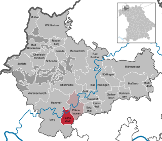
Fuchsstadt is a municipality in the district of Bad Kissingen in Bavaria in Germany.

<span class="mw-page-title-main">Motten</span> Municipality in Bavaria, Germany

Motten is a municipality in the district of Bad Kissingen in Bavaria in Germany.

<span class="mw-page-title-main">Oberthulba</span> Municipality in Bavaria, Germany

Oberthulba is a municipality in the district of Bad Kissingen in Bavaria in Germany.

<span class="mw-page-title-main">Oberding</span> Municipality in Bavaria, Germany

Oberding is a municipality in the district of Erding in Upper Bavaria in Germany, and member of the same administrative community. Almost half of the area of Munich Airport, including both terminals, falls within the municipal bounds.

<span class="mw-page-title-main">Kalchreuth</span> Municipality in Bavaria, Germany

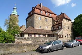
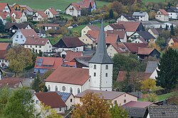
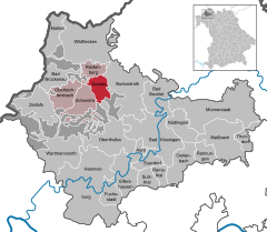
Kalchreuth is a municipality in the district of Erlangen-Höchstadt, in Bavaria, Germany. It is located 10 kilometers east of Erlangen and 15 kilometers north of Nuremberg and contains the villages of Kalchreuth, Käswasser and Röckenhof and also the hamlets of Stettenberg, Minderleinsmühle and Gabermühle.

<span class="mw-page-title-main">Kleinsendelbach</span> Municipality in Bavaria, Germany

Kleinsendelbach is a municipality in the district of Forchheim in Bavaria in Germany. It is located about 17 Kilometers south of the town of Forchheim and 15 Kilometers to the east of the city of Erlangen, and is part of the administration community Dormitz.

<span class="mw-page-title-main">Pinzberg</span> Municipality in Bavaria, Germany

Pinzberg is a municipality in the district of Forchheim in Bavaria in Germany.

<span class="mw-page-title-main">Leupoldsgrün</span> Municipality in Bavaria, Germany

Leupoldsgrün is a municipality in Upper Franconia. It can be found in the district of Hof, which is part of Bavaria, Germany.

<span class="mw-page-title-main">Trogen, Bavaria</span> Municipality in Bavaria, Germany

Trogen is a municipality in Upper Franconia in the district of Hof in Bavaria in Germany.

<span class="mw-page-title-main">Neudrossenfeld</span> Municipality in Bavaria, Germany

Neudrossenfeld is a municipality in the district of Kulmbach in Upper Franconia in Bavaria, Germany.

<span class="mw-page-title-main">Stiefenhofen</span> Municipality in Bavaria, Germany

Stiefenhofen is a municipality in the district of Lindau in Bavaria in Germany and the seat of the administrative community of Stiefenhofen.

<span class="mw-page-title-main">Ampfing</span> Municipality in Bavaria, Germany

Ampfing is a municipality in the district of Mühldorf in Bavaria in Germany, and a name of a small town of the same name.

<span class="mw-page-title-main">Sonnen</span> Municipality in Bavaria, Germany

Sonnen is a small municipality in the district of Passau in Bavaria in Germany. It is located in the Danube forest, lower Bavarian forest and is located mostly in the district Passau at a height of 700 to 900 meters. Sonnen lies 28 km from Passau, 9 km from Hauzenberg and from the forest itself 13 km. Sonnen borders with upper Austria which lies only 8 km away.

<span class="mw-page-title-main">Winklarn</span> Municipality in Bavaria, Germany

Winklarn is a market town and municipality in the district of Schwandorf in Bavaria, Germany. In 2006, Winklarn had 1,446 inhabitants. Winklarn lies in the Upper Palatinate. In the North of Winklarn, there is a large forest, the so-called Frauenstein.

<span class="mw-page-title-main">Stetten, Bavaria</span> Municipality in Bavaria, Germany

Stetten is a municipality in the district of Unterallgäu in Bavaria, Germany. The town has a municipal association with Dirlewang.

References