
Valley of Flowers National Park is an Indian national park which was established in 1982. It is located in Chamoli in the state of Uttarakhand and is known for its meadows of endemic alpine flowers and the variety of flora. This richly diverse area is also home to rare and endangered animals, including the Asiatic black bear, snow leopard, musk deer, brown bear, red fox and blue sheep. Birds found in the park include Himalayan monal pheasant and other high-altitude birds.
Auli is in Chamoli district in the Himalayan mountains of Uttarakhand, India. Auli, also known as Auli Bugyal, in Garhwali, which means "meadow", is located at an elevation of 2,800 metres (9,200 ft) above sea level. Between June and October, the valley has one of highest numbers of flower species found anywhere in the world, with 520 species of high-altitude plants, 498 of which are flowering plants with significant populations of endangered species.

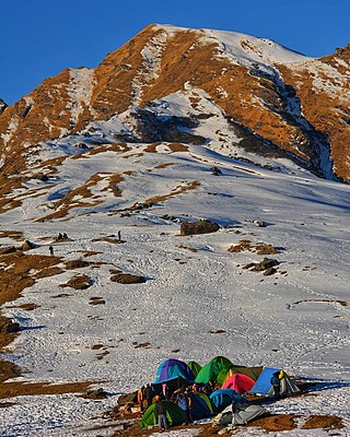
Bugyals are alpine pasture lands, or meadows, in higher elevation range between 3,300 metres (10,800 ft) and 4,000 metres (13,000 ft) of the Himalayas in the Indian state of Uttarakhand, where they are called "nature’s own gardens". The topography of the terrain is either flat or sloped. The surface of these bugyals is covered with natural green grass and seasonal flowers. They are used by tribal herdsmen to graze their cattle. During the winter season the alpine meadows remain snow-covered. During summer months, the Bugyals present a riot of beautiful flowers and grass. As bugyals constitute very fragile ecosystems, particular attention needs to be given for their conservation.

Gangotri National Park is a national park in Uttarkashi District in Uttarakhand state of India, covering about 2,390 km2 (920 sq mi). Its habitat consists of coniferous forests, alpine meadows and glaciers. Gomukh at Gangotri glacier, the origin of the river Ganga, is located inside the park. Gangotri National Park was established in 1989.

Uttarkashi, meaning Kashi of the north, is a town located in Uttarkashi district in Uttarakhand, India. Uttarkashi town is headquarters of the district. Uttarkashi is also known as Somya Kashi. Uttarkashi is a Hindu religious place for spiritual and adventurous tourism. Uttarkashi town is also called as Shivnagri. The town has number of temples and ashrams. Uttarkashi is known for its religious people, weather, education.
Kedarnath Wild Life Sanctuary, also called the Kedarnath Musk Deer Sanctuary, is a wildlife sanctuary declared under Wildlife Protection Act, 1972 and located in Uttarakhand, India. Its alternate name comes from its primary purpose of protecting the endangered Himalayan musk deer. Consisting of an area of 975 km2 (376 sq mi), it is the largest protected area in the western Himalayas.It is famous for alpine musk deer, Himalayan Thar, Himalayan Griffon, Himalayan Black bear, Snow Leopard and other flora park and fauna. It is internationally important for the diversity of its flora and fauna.

Uttarakhand has a total geographic area of 53,483 km2, of which 86% is mountainous and 65% is covered by forest. Most of the northern parts of the state are part of Greater Himalaya ranges, covered by the high Himalayan peaks and glaciers, while the lower foothills were densely forested till denuded by the British log merchants and later, after independence, by forest contractors. Recent efforts in reforestation, however, have been successful in restoring the situation to some extent. The unique Himalayan ecosystem plays host to many animals, plants and rare herbs. Two of India's great rivers, the Ganges and the Yamuna take birth in the glaciers of Uttarakhand, and are fed by myriad lakes, glacial melts and streams.

Chopta is a small region of meadows and evergreen forest area, a part of Kedarnath wildlife sanctuary located in Uttarakhand state, India and a base for trekking to Tungnath, the third temple of Panch Kedar which lies 3.5 kilometres (2.2 mi) away. Located at a distance of 1.5 kilometres (0.93 mi) from Tungnath is Chandrashila, a summit rising to over 4,000 metres (13,000 ft).
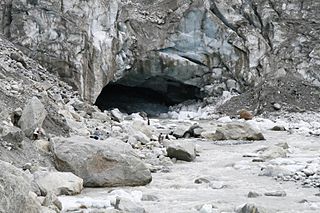
Gomukh, also known as "Gaumukh" or "Gomukhi", is the terminus or snout of the Gangotri Glacier and the source of the Bhagirathi River, one of the primary headstreams of the Ganga River. The word Gomukh/Gaumukh literally means "Mouth of a Cow."

Yamunotri Temple is a Hindu temple, situated in the western region of Garhwal Himalayas at an altitude of 3,291 metres (10,797 ft) in Uttarkashi district, Uttarakhand, India. It's just 129 km from Uttarkashi, the main district headquarters. The temple is dedicated to Goddess Yamuna, and has a black marble idol of the goddess. The Yamunotri temple is a full day's journey from Uttarakhand's main towns — Uttarkashi, Rishikesh, Haridwar or Dehradun.
The Krishansar Lake or Krishan Sar is an alpine high elevation oligotrophic lake situated near Sonamarg, in the Ganderbal district of Jammu and Kashmir in India at an elevation of 3,710 metres (12,170 ft). It is located less than one kilometer northwest of Vishansar Lake, and has a maximum length of 0.95 km and maximum width of 0.6 km.
Govind Pashu Vihar National Park and Wildlife Sanctuary is a national park in Supin Range, near Uttarkashi town in the district and state of the same name in India. It was established initially as a wildlife sanctuary in 1955, and was later converted into a national park. It is named after prominent Indian freedom fighter and politician Govind Ballabh Pant, who became Home Minister in 1955 and is credited for establishing Hindi as an official language of India.

Dudhatoli is a middle Himalayan mountain range/forest running approximately 25 km in a north–south direction, starting near Thalisain tehsil of Pauri Garhwal district in Uttarakhand, with Gairsain in Chamoli district being its western limit and Syoli-Khand region in Pauri its northernmost spur.
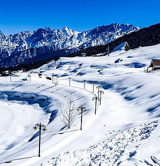
Gorson Bugyal is a Himalayan Alpine Meadow in Auli, Chamoli district of Uttarakhand. Gorson Bugyal is a skiing destination. The Bugyal has an average elevation of 3519m and is around 19 km from Joshimath. It is a large alpine meadow which has expanse of grass land that covers several hundred acres of land. It has a well maintained trek route. The trek to Gorson Bugyal passes through lush vegetation of apple orchards, oak and deodar forests.

Panwali Kantha Bugyal is a Himalayan Alpine Meadow in the Tehri Garhwal district of Uttarakhand. Panwali Kantha Bugyal is a trekking and hiking Destination. The Bugyal has an average elevation of 3368m and is around 90 km from New Tehri. It is an alpine meadow which has expanse of grass land. It has a well maintained trek route. The trek to Panwali Kantha Bugyal passes through lush vegetation of rhododendrons, oak and deodar forests.
Chopta Bugyal, also known as "Tungnath Bugyal" or "Rohini Bugyal", is a cluster of Bugyals in Chopta, Rudraprayag district of Uttarakhand. Chopta Bugyal is a trekking and camping destination. The Bugyal has an average elevation of 2,849 m (9,347 ft) and is around 30 km (19 mi) from Ukhimath. It is situated on the trek route to Tungnath, the third temple of the Panch Kedar and the highest Shiva temple in the world and Chandrashila, a summit at an altitude of 3,645 m (11,959 ft). Chopta Bugyal is surrounded by forests of pine, deodar and rhododendron and is rich in flora and fauna.

Dayara Bugyal is a Bugyal in the Uttarkashi district of Uttarakhand. Dayara Bugyal is a popular trekking and camping destination. The Bugyal has an average elevation of 3639m and is around 40 km from Uttarkashi. It is nestled between the Deodar and Rhododendron trees and is rich in flora and fauna.
Khaliya Bugyal is a Bugyal in the Pithoragarh district of Uttarakhand. Khaliya Bugyal is a trekking and skiing destination. The Bugyal has the highest elevation of 3709m and is around 16 km from Munsiyari. Khaliya Bugyal is situated between the snowy peaks and the forests of Deodar, Pine and Rhododendrons.

"Kush Kalyan" is a bugyal in the Tehri Garhwal district of Uttarakhand, India. Kush Kalyan Bugyal is a popular trekking and camping Destination. The Bugyal has the highest elevation of 3789m. The trek is of 16 km and starts from Malla, which is around 30 km from Uttarkashi. The trek to Kush Kalyan goes through dense forests, past lakes, and amongst wild flora and fauna.
Sankri is a village situated at an altitude of 1950 m above sea level in Mori Tehsil, Uttarkashi district, Uttarakhand, India. Part of the Govind Balabh Pant Wildlife Sanctuary, Sankri is 25 km away from the sub-district headquarters Mori and 195 km from the district headquarters Uttarkashi. Barkot is the closest town to Sankri at approximately 86 km. The total geographical area of Sankri village is 40.01 hectares. According to 2009 statistics, Saur is the gram panchayat of Sankri, and according to 2011 census information, the location code or village code of Sankari village is 040230.
 Gidara Bugyal
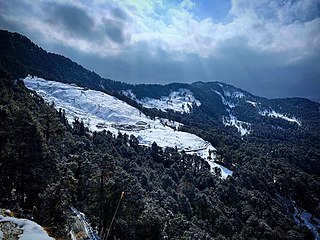
 Gidara Bugyal covered with snow
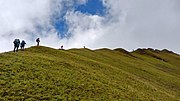 Ridge walking at Gidara Bugyal
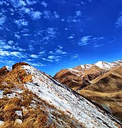 Gidara Bugyal


