Moffett Federal Airfield, also known as Moffett Field, is a joint civil-military airport located in an unincorporated part of Santa Clara County, California, United States, between northern Mountain View and northern Sunnyvale. On November 10, 2014, NASA announced that it would be leasing 1,000 acres (400 ha) of the airfield property to Google for 60 years.

Marine Corps Air Station El Toro was a United States Marine Corps Air Station located next to the community of El Toro and was then adjacent to the city of Irvine.

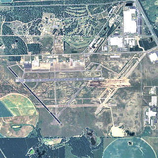
Orlando Sanford International Airport is in Sanford, Florida, United States, near Orlando. It was built as Naval Air Station Sanford, a Master Jet Base for carrier-based attack and reconnaissance aircraft, and was used by the U.S. Navy until 1969. The airport is owned and operated by the Sanford Airport Authority. It serves as an operating base for Allegiant Air.

Marine Corps Air Station Miramar is a United States Marine Corps installation that is home to the 3rd Marine Aircraft Wing, which is the aviation element of the I Marine Expeditionary Force. It is located in Miramar, a community of San Diego, California, about 14 miles (23 km) north of downtown San Diego.

Brown Field Municipal Airport is in the Otay Mesa neighborhood of San Diego, California, United States, 13 miles (21 km) southeast of downtown San Diego and named in honor of Commander Melville S. Brown, USN, who was killed in an airplane crash in 1936. Its main runway is 7,972 feet (2,430 m) long. Its FAA/IATA airport code is SDM. Formerly Naval Auxiliary Air Station Brown Field, it is now a civilian reliever airport and a port of entry from Mexico. It is sometimes staffed by U.S. Customs and Border Protection, but only upon request of incoming pilots to the Federal Aviation Administration. The development plans for the SDM airport have been announced on 4th Oct 2022, the development will occur in phases over 20 years. The plans include a new FBO terminal building and individual airplane hangars. There is also talk of adding a million square feet of retail and industrial buildings and possibly a hotel.

Pitt–Greenville Airport is a public airport located two miles (3 km) north of the central business district of Greenville, North Carolina, and East Carolina University. The airport covers 872 acres (353 ha) and has two runways. It is mostly used for general aviation but is also served by American Airlines, which operates commuter service to Charlotte. The airport manager is Kim W. Hopper.

Miami-Opa Locka Executive Airport is a joint civil-military airport located in Miami-Dade County, Florida 11 mi (18 km) north of downtown Miami. Part of the airport is in the city limits of Opa-locka. The National Plan of Integrated Airport Systems for 2011–2015 called it a general aviation reliever airport.

Camarillo Airport is a public airport located three miles (5 km) west of the central business district of Camarillo, a city in Ventura County, California, United States. The airport has one runway and serves privately operated general aviation and executive aircraft with no scheduled commercial service. A separate, uncontrolled runway in the southwest quadrant of the airport is for exclusive use of light-sport aircraft and ultralights, and is not connected to the larger airport. The airport is the site for an annual air show "Wings Over Camarillo", organized by the Southern California Wing of the Commemorative Air Force.
North Perry Airport is a public airport in the City of Pembroke Pines, 5 miles (8 km) west of the central business district of Hollywood, in Broward County, Florida, United States. It is also known as Hollywood North Perry Airport, hence the HWO codes. The airport is owned by the Broward County Aviation Department. It is a general aviation airport devoted to private and business light aircraft activity.

Coastal Carolina Regional Airport is a commercial airport located three miles (5 km) southeast of the central business district of New Bern, a city in Craven County, North Carolina, United States. EWN covers 785 acres of land.

Chino Airport is a county-owned airport about three miles southeast of Chino, in San Bernardino County, California, United States. The Federal Aviation Administration's National Plan of Integrated Airport Systems for 2007–2011 classified it as a reliever airport, due to its proximity to the Ontario International Airport and the John Wayne Airport.

Chicago/Aurora Municipal Airport is a public airport opened in April 1966, located in the village of Sugar Grove, Illinois, United States, 8 miles (13 km) west of the city of Aurora, both in Kane County. The airport is owned and operated by the City of Aurora. It is 50 miles (80 km) west of Chicago and is designated as a reliever airport for Chicago's O'Hare and Midway airports.

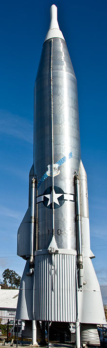
Marine Corps Air Station Eagle Mountain Lake was a United States Marine Corps (USMC) air station that was located 23 miles (37 km) northwest of Fort Worth, Texas during World War II, next to the lake of the same name. Commissioned on 1 December 1942, the air station was originally home to the Marine Corps military glider program. When the program was cancelled in 1943 the station was used to train USMC dive bomber pilots and later became home to the Marines' night fighter program. After the war the air station went into caretaker status in December 1946, became an outlying landing field of Naval Air Station Dallas, and was later used by the Texas Army National Guard and other branches of the U.S. military before being sold to a private owner in the 1970s. Today, the facility is a private airport run by Kenneth Copeland Ministries as Kenneth Copeland Airport.

Cable Airport is a non-towered public-use airport located two miles (3 km) northwest of the central business district of Upland, a city in San Bernardino County, California, United States. It is privately owned by the Cable Land Company.
Paso Robles Municipal Airport is four miles (6.4 km) northeast of downtown Paso Robles, in San Luis Obispo County, California, United States.
Decatur County Industrial Air Park is a county-owned public-use airport located six nautical miles (11 km) northwest of the central business district of Bainbridge, a city in Decatur County, Georgia, United States.

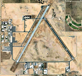
Coolidge Municipal Airport is a city-owned public airport 5 miles southeast of Coolidge, in Pinal County, Arizona, United States.
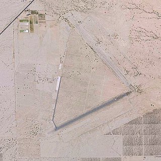
Desert Center Airport is a private-use airport located five nautical miles northeast of the central business district of Desert Center, in Riverside County, California, United States.

Rolle Airfield, also known as Rolle Field, formally Yuma Auxiliary Army Airfield No. 4, is a public use non-towered airport owned by United States Department of the Interior, and managed by the Yuma County Airport Authority. The airport is located in San Luis, Arizona, 14 miles south of the central business district of Yuma, a city in Yuma County, Arizona, United States. It is 146 miles east of San Diego International Airport. The airport is 3.5 miles north of the Mexico–United States border.