Devils Lake Regional Airport is a public use airport located two nautical miles (4 km) west of the central business district of Devils Lake, a city in Ramsey County, North Dakota, United States. It is owned by the Devils Lake Airport Authority and was formerly known as Devils Lake Municipal Airport. A new terminal recently opened for business at the airport. DVL is mostly used for general aviation but is also served by one commercial airline, with flights two times daily. Scheduled passenger service is subsidized by the Essential Air Service program.
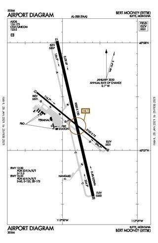
Bert Mooney Airport is a public airport three miles southeast of Butte, in Silver Bow County, Montana, United States. It is owned by the Bert Mooney Airport Authority.

McNary Field is in Marion County, Oregon, United States, two miles southeast of downtown Salem, which owns it. The airport is named for U.S. Senator Charles L. McNary.
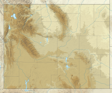
Worland Municipal Airport is in Washakie County, Wyoming, three miles south of Worland, which owns it. It was built in 1953. It has no scheduled airline service; Great Lakes Airlines pulled out on September 30, 2016.

Laramie Regional Airport is three miles west of Laramie, in Albany County, Wyoming. It is owned by the Laramie Regional Airport Board. Airline service is subsidized by the Essential Air Service program.

Central Wyoming Regional Airport, formerly Riverton Regional Airport, is three miles northwest of Riverton, in Fremont County, Wyoming; it also serves nearby Lander, Wyoming. It is used for general aviation and sees one passenger airline. Service was subsidized by the Essential Air Service program until October 2006, when Great Lakes Airlines began providing subsidy-free service. Key Lime Air operating as the Denver Air Connection began serving the airport with regional jet aircraft on July 1, 2016.
Sheridan County Airport is located in Sheridan County, Wyoming, approxiametly two miles southwest of the city of Sheridan, Wyoming. It serves both commercial and general aviation, as well as military aircraft.

Western Nebraska Regional Airport is three miles east of Scottsbluff, in Scotts Bluff County, Nebraska. The airport is owned by the Airport Authority of Scotts Bluff County and is named after William B. Heilig. Known as "Scottsbluff's Mr. Aviation," he was a World War II United States Army Air Force primary flight instructor, a civil flight instructor, and manager of the city's airport.

Liberal Mid-America Regional Airport is two miles west of Liberal, in Seward County, Kansas. It is used for general aviation and is subsidized by the Essential Air Service program. Formerly Liberal Municipal Airport, it hosts the Mid-America Air Museum.

Waynesville-St. Robert Regional Airport, also known as Forney Field, is a public and military use airport located at Fort Leonard Wood in Pulaski County, Missouri, United States. The airport's passenger terminal is operated under the control of the U.S. Army and general aviation is under the direction of a board named by the cities of Waynesville and St. Robert. Formerly known as Waynesville Regional Airport at Forney Field, it is served by one commercial airline with scheduled service subsidized by the Essential Air Service program.
Fayetteville Regional Airport, also known as Grannis Field, is a public use airport in Cumberland County, North Carolina, United States. It is owned by the city of Fayetteville and located three nautical miles (6 km) south of its central business district.

Lynchburg Regional Airport, also known as Preston Glenn Field, is a public use airport in Campbell County, Virginia, United States. It is located at the intersection of Route 29 South and Route 460, five nautical miles southwest of the central business district of the City of Lynchburg, which owns the airport. Opened in 1931, it was originally named Preston Glenn Airport in honor of Lt. Preston Glenn, a Lynchburg native who died while serving in World War I as an Army Air Corps pilot. Mostly used for general aviation, the airport is also served by one commercial airline, American Airlines, flying Embraer ERJ-145 aircraft to Charlotte Douglas International Airport in Charlotte, North Carolina.

John Murtha Johnstown–Cambria County Airport is a civil-military airport three miles (5 km) northeast of Johnstown, in Cambria County, Pennsylvania. It is owned by Johnstown–Cambria County Airport Authority and is named after the late Congressman John Murtha. It sees one airline, subsidized by the Essential Air Service.

Arnold Palmer Regional Airport is in Westmoreland County, Pennsylvania, United States, two miles (3 km) southwest of Latrobe and about 33 miles (53 km) southeast of Pittsburgh. It was formerly Westmoreland County Airport; it was renamed in September 1999 for Arnold Palmer as part of his 70th birthday celebration. Palmer learned to fly at the airport, and the dedication ceremony included Governor Tom Ridge and a flyover of three A-10s of the Pennsylvania Air National Guard.
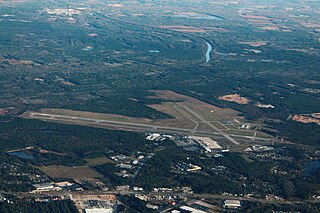
Tri-Cities Airport, is in Blountville, Tennessee, United States. It serves the Tri-Cities area of Northeast Tennessee and Southwest Virginia. The airport is governed by the Tri-Cities Airport Authority (TCAA) whose members are appointed by the cities of Johnson City, Kingsport, Bristol (TN), Bristol (VA) and both Washington and Sullivan counties in Tennessee.

Merle K. (Mudhole) Smith Airport is a state-owned public-use airport located 11 nautical miles southeast of the central business district of Cordova, a city in the Chugach Census Area of the U.S. state of Alaska which has no road access to the outside world. Airline service is subsidized by the Essential Air Service program.
Tunica Municipal Airport is a public use airport located one nautical mile (2 km) east of the central business district of Tunica, in Tunica County, Mississippi, United States. It is owned by the Tunica County Airport Commission. Also known as Tunica Airport, it should not be confused with the 10 acre privately owned, public use Tunica Airport located 2 nautical miles (4 km) south of the center of town, which has been recently changed to Ralph M Sharpe Airport.

Gustavus Airport is a state-owned public-use airport located in Gustavus, a city in the Hoonah-Angoon Census Area of the U.S. state of Alaska. Scheduled airline service is subsidized by the Essential Air Service program.
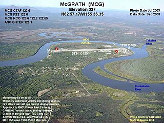
McGrath Airport is a state-owned public-use airport serving McGrath, a city in the Yukon-Koyukuk Census Area of the U.S. state of Alaska.

Newport Municipal Airport is a city-owned, public-use airport located three nautical miles (6 km) south of the central business district of Newport, a city in Lincoln County, Oregon, United States. It is included in the National Plan of Integrated Airport Systems for 2011–2015, which categorized it as a general aviation facility.