
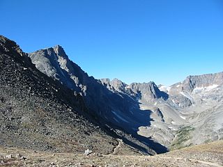
Absaroka–Beartooth Wilderness was created from existing National Forest lands in 1978 and is located in Montana and Wyoming, United States. The wilderness encompasses two distinct mountain ranges: the Beartooth and Absaroka ranges. These ranges are completely distinct geologically speaking, with the Absaroka composed primarily of volcanic and metamorphic rock, while the Beartooth is made up almost entirely of granitic rocks. The Absaroka are noted for their dark and craggy appearance, lush and heavily forested valleys, and abundant wildlife. The highest peak in the range, in Wyoming, is Francs Peak at 13,153 feet (4,009 m). The Beartooth is more alpine, with huge treeless plateaus and the highest peak of Montana. The wilderness has more than 120 peaks over 10,000 feet (3,000 m) and 28 peaks over 12,000 feet (3,700 m), including Montana's highest, Granite Peak at 12,799 feet (3,901 m). The wilderness is integral to the 20-million-acre (81,000 km2) Greater Yellowstone Ecosystem and borders Yellowstone National Park.
Crazy Peak, elevation 11,214 ft (3,418 m), is the highest peak in the Crazy Mountains, an island range of the Montana Rockies, in the United States. Crazy Peak dominates the surroundings, rising over 7,000 feet (2,100 m) above the Yellowstone River Valley, and is the highest peak in Montana north of the Beartooth Mountains, which are 50 miles (80 km) to the south. Crazy Peak is also the most topographically prominent peak in Montana. A small glacier exists on the northeast slope of the mountain. The mountain is located on private land within the Gallatin National Forest.
Beartooth Glacier is in the U.S. state of Montana. The glacier is situated in a cirque northeast of Beartooth Mountain at an average elevation of 10,500 feet (3,200 m) above sea level.
Hopper Glacier is located in the US state of Montana. The glacier is situated east of Sky Pilot Mountain in the Beartooth Mountains at an elevation of 11,000 feet (3,400 m) above sea level.
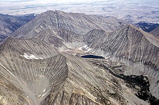
Granite Glacier is located in the US state of Montana. The glacier is situated in the Beartooth Mountains at an elevation of 11,000 feet (3,400 m) above sea level and is on the north slope of Granite Peak, the highest summit in Montana. The glacier covers approximately 40 acres (0.16 km2).
Hidden Glacier is located in the US state of Montana. The glacier is situated in the Beartooth Mountains at an elevation of 10,500 feet (3,200 m), nestled within a cirque between Mount Villard to the east and Glacier Peak to the west. The glacier covers approximately 10 acres (0.040 km2).
Sky Top Glacier is in the Beartooth Mountains in the U.S. state of Montana. The glacier is situated at an elevation of 11,600 feet (3,500 m) in a cirque to the west of Granite Peak, the tallest summit in Montana. The glacier covers approximately 25 acres (0.10 km2) and a small proglacial lake is near the glacier terminus.
Castle Mountain is in the Beartooth Mountains in the U.S. state of Montana, about 15 miles (24 km) east-northeast of Cooke City. It is located in the Gallatin National Forest and Custer National Forest, just outside the northern boundary of Yellowstone National Park in the Absaroka–Beartooth Wilderness.
Whitetail Peak is in the Beartooth Mountains in the U.S. state of Montana. The peak is one of the tallest in the Beartooth Mountains, the fifth-tallest in Montana, and is located in the Absaroka-Beartooth Wilderness of Custer National Forest.
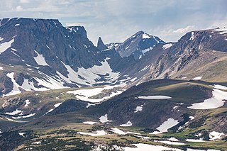
Castle Rock Spire is in the Beartooth Mountains in the U.S. state of Montana. The peak is one of the tallest in the Beartooth Mountains, the seventh tallest in Montana and in the Absaroka-Beartooth Wilderness of Custer and Gallatin National Forests. Castle Rock Spire is only .50 mi (0.80 km) WSW of Castle Mountain. The Sundance Glacier lies on the north slopes of the peak.
Tempest Mountain is in the Beartooth Mountains in the U.S. state of Montana. The peak is one of the tallest in the Beartooth Mountains, the eighth tallest in Montana and is in the Absaroka-Beartooth Wilderness of Custer National Forest. Tempest Mountain is less than 1 mi (1.6 km) ENE of Granite Peak, the tallest mountain in Montana.
Castle Rock Mountain is in the Beartooth Mountains in the U.S. state of Montana. The peak is one of the tallest in the Beartooth Mountains, the tenth-tallest in Montana and is in the Absaroka-Beartooth Wilderness, on the border of Custer and Gallatin national forests. The nearest taller mountain to Castle Rock Mountain is Castle Rock Spire, 0.65 mi (1.05 km) east. Castle Rock Mountain is flanked by the Sundance Glacier to the north and the Castle Rock Glacier to the south.
Bowback Mountain is in the Beartooth Mountains in the U.S. state of Montana. The peak is one of the tallest in the Beartooth Mountains, the 11th tallest in Montana and is in the Absaroka-Beartooth Wilderness in Custer National Forest.
Beartooth Mountain is in the Beartooth Mountains in the U.S. state of Montana. The peak is one of the tallest in the Beartooth Mountains, the 11th tallest in Montana and is in the Absaroka-Beartooth Wilderness in Custer National Forest. Along a ridge .29 mi (0.47 km) to the northeast lies the spire known as Bears Tooth.

Mount Villard is in the Beartooth Mountains in the U.S. state of Montana. The peak is one of the tallest in the Beartooth Mountains and is in the Absaroka-Beartooth Wilderness on the border of Custer and Gallatin National Forests. Hidden Glacier lies to the northwest of the peak.
Mount Hague is in the Beartooth Mountains in the U.S. state of Montana. The peak is one of the tallest in the Beartooth Mountains and is in the Absaroka-Beartooth Wilderness of Custer National Forest.

Spirit Mountain is in the Beartooth Mountains in the U.S. state of Montana. The peak is one of the tallest in the Beartooth Mountains and is in the Absaroka-Beartooth Wilderness, in Custer National Forest.

Mount Rearguard is in the Beartooth Mountains in the U.S. state of Montana. The peak is one of the tallest in the Beartooth Mountains and is in the Absaroka-Beartooth Wilderness in Custer National Forest. A small remnant glacier lies to the east of Mount Rearguard, which sits at the western edge of the Hellroaring Plateau.
Snowbank Mountain is in the Beartooth Mountains in the U.S. state of Montana. The peak is in the Absaroka-Beartooth Wilderness in Custer National Forest. The tiny Snowbank Glacier lies immediately southeast of the peak.
Sky Pilot Mountain is in the Beartooth Mountains in the U.S. state of Montana. The peak is in the Absaroka-Beartooth Wilderness on the borders of Custer and Gallatin National Forests. The Hopper Glacier lies on the east flank of the peak.


