
Castleford is a town within the City of Wakefield district, West Yorkshire, England. It had a population of 45,106 at a 2021 population estimate. Historically in the West Riding of Yorkshire, to the north of the town centre the River Calder joins the River Aire and the Aire and Calder Navigation. It is located north east of Wakefield, north of Pontefract and south east of Leeds. Castleford is the largest town in the Wakefield district after Wakefield itself.

Ledston is a village in the Leeds metropolitan borough, in the county of West Yorkshire, England. It is 3 miles (5 km) north of Castleford and 10 miles (16 km) east of Leeds. The parish had a population of 400 in 2001, which decreased slightly to 394 at the 2011 Census.

Wakefield, also known as the City of Wakefield, is a local government district with city status and a metropolitan borough in West Yorkshire, England. Wakefield, the largest settlement, is the administrative centre of the district. The population of the City of Wakefield at the 2011 Census was 325,837.

Kexbrough is a village in the Barnsley district, in the county of South Yorkshire, England, on the border with West Yorkshire. The village falls within the Darton West ward of Barnsley MBC. It is located west of the M1 motorway, just south of Junction 38 at an elevation of around 351 feet (107 m) above sea level. Historically the village was known as Kexborough, and includes the hamlets of Haigh and Swithin. Until 1974 it was in the West Riding of Yorkshire.

Carlton is a village in the Metropolitan Borough of Barnsley in South Yorkshire, England. It is situated between the villages of Athersley and Royston. The village is split into two parts, one half in the Monk Bretton ward and the rest in the Royston ward of the Barnsley MBC. It was built up on coking and coal mining industries and now has one of the largest industrial estates within the surrounding area. In the industrial estate lies a glass recycling plant, called Rexam. To its east stands the Mr Kipling cake factory, owned by Premier Foods. Until 1974 it was in the West Riding of Yorkshire.
The Pontefract line is one of the rail services in the West Yorkshire Metro area of northern England. The service is operated by Northern, and links Wakefield and Leeds with Goole via Pontefract. The Metro timetable for the line also includes services operated as the Dearne Valley line between York and Sheffield via Pontefract.

Methley is a dispersed village in the City of Leeds metropolitan borough, south east of Leeds, in West Yorkshire, England. It is located near Rothwell, Oulton, Woodlesford, Mickletown and Allerton Bywater. The Leeds City Ward is called Kippax and Methley. It is within the triangle formed by Leeds, Castleford and Wakefield, and between the confluence of the River Aire and River Calder. The latter is crossed by Methley Bridge, the A639 road, about a mile south-east of the village.

Ackton is a hamlet in the parish of Featherstone, in the Wakefield district of West Yorkshire, England. It is near Pontefract. In 1931 the parish had a population of 961.
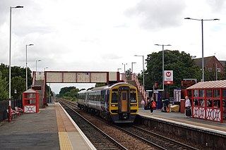
Glasshoughton railway station serves Glasshoughton, Castleford in West Yorkshire, England. It lies on the Pontefract Line, operated by Northern, 12 miles (19 km) south-east of Leeds.

Altofts is a village in the civil parish of Normanton and Altofts, in the City of Wakefield, West Yorkshire, England. It lies 5 miles (8 km) north-east from the centre of Wakefield and less than 1 mile (1.6 km) north-west of Normanton. The M62 runs close to the village to the north-east, and the Aire and Calder Navigation to the north-west.
Upton is a village in the civil parish of Upton and North Elmsall, in the City of Wakefield, West Yorkshire, England. The parish had a population of 3,541 in the 2001 census.

Thorpe on the Hill is a village in the Leeds district, in the county of West Yorkshire, England. The village falls within the Ardsley and Robin Hood ward of the Leeds Metropolitan Council. It was mentioned as "Torp" in the Domesday Book together with neighbouring Carlton, Lofthouse, Middleton, and Rothwell as part of the Morley Hundred in the West Riding.

Ferry Fryston is a suburb of the town of Castleford in West Yorkshire, England. It is situated in the metropolitan borough of the City of Wakefield. The appropriate ward is called Airedale and Ferry Fryston.
East Hardwick is a village and civil parish in the City of Wakefield in West Yorkshire, England. It has a population of 191, reducing to 173 at the 2011 Census. Until 1974 it was part of Osgoldcross Rural District.

Wintersett is a hamlet in the Wakefield district, in West Yorkshire, England. At the 2001 census the population of the parish was 50. Until 1974 it formed part of Wakefield Rural District in the West Riding of Yorkshire. It gives its name to the nearby Wintersett Reservoir.

The Municipal Borough of Castleford was a local government district in the West Riding of Yorkshire from 1955 to 1974 around the town of Castleford, covering Airedale, New Fryston, Whitwood, Cutsyke, Glasshoughton and Whitwood. The Castleford Urban District administered the town from 1894 to 1955.

Monkhill is an area of Pontefract, in the Wakefield district, in the county of West Yorkshire, England.
The Yorkshire Electric Tramways operated two separate tramway services. One in Wakefield between 1904 and 1932, and the other between Normanton, Pontefract and Castleford between 1906 and 1932

Sitlington, historically Shitlington, was a township in the ancient ecclesiastical parish of Thornhill in the wapentake of Agbrigg and Morley in the West Riding of Yorkshire comprising the villages and hamlets of Middlestown, Netherton, Overton and Midgley. The h was dropped from Shitlington and Sitlington was adopted in 1929 with the approval of the county council. The population of the civil parish at the 2011 census was 5,963.

Carleton is a small village on the southern outskirts of Pontefract, in the Wakefield district, in the county of West Yorkshire, England. The village is home to the parish church of St Michael the Archangel, and two schools, Carleton High School and the Rookeries primary school. Pontefract RUFC is also based in the village.


