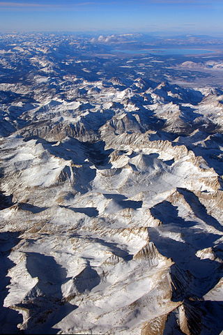
The Sierra Nevada is a mountain range in the Western United States, between the Central Valley of California and the Great Basin. The vast majority of the range lies in the state of California, although the Carson Range spur lies primarily in Nevada. The Sierra Nevada is part of the American Cordillera, an almost continuous chain of mountain ranges that forms the western "backbone" of the Americas.

The John Muir Trail (JMT) is a long-distance trail in the Sierra Nevada mountain range of California, passing through Yosemite, Kings Canyon and Sequoia National Parks. It is named after John Muir, a naturalist.
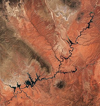
Lake Powell is an artificial reservoir on the Colorado River in Utah and Arizona, United States. It is a major vacation destination visited by approximately two million people every year. It is the second largest artificial reservoir by maximum water capacity in the United States behind Lake Mead, storing 24,322,000 acre-feet (3.0001×10¹⁰ m3) of water when full. However, Lake Mead has fallen below Lake Powell in size several times during the 21st century in terms of volume of water, depth and surface area.

The John Muir Wilderness is a wilderness area that extends along the crest of the Sierra Nevada of California for 90 miles (140 km), in the Inyo and Sierra National Forests. Established in 1964 by the Wilderness Act and named for naturalist John Muir, it encompasses 652,793 acres (2,641.76 km2). The wilderness lies along the eastern escarpment of the Sierra from near Mammoth Lakes and Devils Postpile National Monument in the north, to Cottonwood Pass near Mount Whitney in the south. The wilderness area also spans the Sierra crest north of Kings Canyon National Park, and extends on the west side of the park down to the Monarch Wilderness.
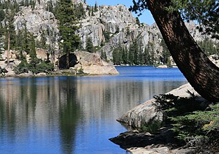
The Emigrant Wilderness of Stanislaus National Forest is a wilderness area in the Sierra Nevada. It is bordered by Yosemite National Park on the south, the Toiyabe National Forest and the Hoover Wilderness on the east, and State Route 108 over Sonora Pass on the north. It is an elongated area that extends northeast about 25 miles (40 km) in length and up to 15 miles (24 km) in width. Watersheds drain to the Stanislaus and Tuolumne Rivers. The Emigrant Wilderness area, which is a glaciated landscape, is entirely within Tuolumne County, California and is approximately 140 miles (230 km) east of San Francisco, California and 50 miles (80 km) south of Lake Tahoe.

Mount Williamson, at an elevation of 14,379 feet (4,383 m), is the second-highest mountain in both the Sierra Nevada range and the state of California, and the sixth-highest peak in the contiguous United States.

Mount Langley is a mountain located on the crest of the Sierra Nevada, on the boundary between Inyo and Tulare counties in eastern California, in the United States. To the east is the Owens Valley, and to the west is the Kern River Valley. It is the ninth-highest peak in the state and the seventh-highest in the Sierra. Mount Whitney, the highest peak in the contiguous United States, lies 4.8 miles (7.7 km) to the northwest. Mount Langley also has the distinction of being the southernmost fourteener in the United States.

Split Mountain is a fourteener in the Sierra Nevada of the U.S. state of California, near the southeast end of the Palisades group of peaks. It is the only fourteener in the watershed of the South Fork Kings River, and it rises to 14,064 feet (4,287 m), making it the eighth-highest peak in the state.

Muir Pass is a mountain pass in the Sierra Nevada of California, United States, in Kings Canyon National Park. It is named for John Muir.

Leavitt Peak is located in the Emigrant Wilderness near Sonora Pass in the eastern Sierra Nevada range of California. Leavitt Peak is located on the Tuolumne County - Mono County line. The Pacific Crest Trail runs close to the east of Leavitt Peak, at an elevation of about 10,800 feet (3,290 m) elevation. The peak offers views south to Yosemite National Park and north towards South Lake Tahoe.
The South Sierra Wilderness is a federally designated wilderness area in the Southern Sierra Nevada, in eastern California. It is located 65 miles (105 km) northeast of Bakersfield, and is southwest of Owens Lake and Olancha.

The Dinkey Lakes Wilderness is a federally designated wilderness area located 45 miles (72 km) northeast of Fresno, in the state of California, United States. It comprises 30,000 acres (12,141 ha) within the Sierra National Forest and was added to the National Wilderness Preservation System by the California Wilderness Act of 1984. Elevations range from 8,200 feet (2,500 m) to 10,619 feet (3,237 m). Recreational activities in the wilderness include day hiking, backpacking, horseback riding, fishing, rock climbing and cross-country skiing.

Mono Hot Springs is a summer resort and campground at a group of hot springs in Fresno County, central California. It is located within the Sierra National Forest, 70 miles (110 km) northeast of Fresno via California State Route 168.

Waconda Lake, also known as Glen Elder Reservoir, is a reservoir in Mitchell County and Osborne County, Kansas, United States. Built and managed by the U.S. Bureau of Reclamation for flood control and irrigation, it is also used for recreation. Glen Elder State Park is located on its north shore.
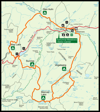
The High Sierra Camps are nine rustic lodging facilities located in two national parks and a national monument in California's Sierra Nevada mountain range. Open most years from June or July to September, they are staffed camps with tent cabins and food service facilities. The backcountry camps receive their supplies by pack mules.

Lake Thomas A Edison is a reservoir in the Sierra National Forest and in Fresno County, California. It is in the Sierra Nevada, and near the Pacific Crest Trail.
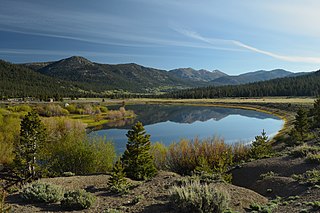
Hope Valley is a broad mountain valley in Alpine County, California, located on the eastern slope of the Sierra Nevada to the northeast of Carson Pass and south of Lake Tahoe. The valley served as a major thoroughfare for the passage of settlers and emigrants to and from California during the Gold Rush era. Sitting at an elevation of just above 7,000 feet (2,100 m) and framed by peaks reaching over 10,000 feet (3,000 m) high, Hope Valley is known for its wide vistas, fly fishing, fall colors, and winter activities.

Mount Rixford is a 12,887-foot-elevation (3,928-meter) mountain summit located one mile west of the crest of the Sierra Nevada mountain range, in the southeast corner of Fresno County, in northern California. It is situated in Kings Canyon National Park, 11.5 miles (18.5 km) west of the community of Independence, and one mile north of the Kearsarge Pinnacles and Kearsarge Lakes. Topographic relief is significant as the north aspect rises 2,346 feet above Rae Lakes in one mile. The John Muir Trail crosses Glen Pass one mile to the west of this mountain. Mt. Rixford ranks as the 183rd highest summit in California. Painted Lady is a subsidiary summit at the end of Rixford's north ridge.

Mount McGee is a 12,944-foot-elevation (3,945-meter) mountain summit located west of the crest of the Sierra Nevada mountain range, in Fresno County of central California, United States. It is situated in northern Kings Canyon National Park, 0.6 miles (0.97 km) southeast of Peter Peak, 2 miles (3.2 km) southwest of The Hermit, and 2.6 miles (4.2 km) north-northwest of Mount Goddard, the nearest higher neighbor. Topographic relief is significant as the west aspect rises 3,100 feet above Goddard Canyon in two miles. This geographical feature was named for William John McGee (1853–1912), well-known American geologist and anthropologist. This mountain's name has been officially adopted by the United States Board on Geographic Names. The first ascent of the summit was made in July 1923 by Roger N. Burnham, Robert E. Brownlee, Ralph H. Brandt, and Leonard Keeler.

Pinchot Pass is a high mountain pass in the Sierra Nevada mountain range of California, in the United States. It lies within far eastern Fresno County, inside Kings Canyon National Park and the Sequoia-Kings Canyon Wilderness.


