Gmina Lubartów

Last updated
Gmina Lubartów
Lubartów Commune
Gmina
POL gmina Lubartow COA.svg
Coat of arms
Lub Lubartowski Lubartow w.png
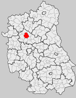
Location within the county and voivodeship
Coordinates(Lubartów): 51°28′N22°36′E / 51.467°N 22.600°E / 51.467; 22.600 Coordinates: 51°28′N22°36′E / 51.467°N 22.600°E / 51.467; 22.600
CountryFlag of Poland.svg  Poland
Voivodeship Lublin
County Lubartów
Seat Lubartów
Area
  Total 158.94 km2 (61.37 sq mi)
Population (2015 [1] )
  Total 11,272
  Density 71/km2 (180/sq mi)
Website http://www.lubartow.gmina.woi.lublin.pl/

Gmina Lubartów is a rural gmina (administrative district) in Lubartów County, Lublin Voivodeship, in eastern Poland. Its seat is the town of Lubartów, although the town is not part of the territory of the gmina.

Gmina administrative division of Poland

The gmina is the principal unit of the administrative division of Poland, similar to a municipality. As of 2010 there were 2,478 gminy throughout the country. The word gmina derives from the German word Gemeinde, meaning "community".

Lubartów County County in Lublin, Poland

Lubartów County is a unit of territorial administration and local government (powiat) in Lublin Voivodeship, eastern Poland. It was established on January 1, 1999, as a result of the Polish local government reforms passed in 1998. Its administrative seat and largest town is Lubartów, which lies 25 kilometres (16 mi) north of the regional capital Lublin. The county also contains the towns of Kock, lying 23 km (14 mi) north-west of Lubartów, and Ostrów Lubelski, 18 km (11 mi) east of Lubartów.

Lublin Voivodeship Voivodeship in Poland

Lublin Voivodeship, or Lublin Province, is a voivodeship, or province, located in southeastern Poland. It was created on January 1, 1999, out of the former Lublin, Chełm, Zamość, Biała Podlaska and (partially) Tarnobrzeg and Siedlce Voivodeships, pursuant to Polish local government reforms adopted in 1998. The province is named after its largest city and regional capital, Lublin, and its territory is made of four historical lands: the western part of the voivodeship, with Lublin itself, belongs to Lesser Poland, the eastern part of Lublin Area belongs to Red Ruthenia, and the northeast belongs to Polesie and Podlasie.

Contents

The gmina covers an area of 158.94 square kilometres (61.4 sq mi), and as of 2006 its total population is 10,212 (11,272 in 2015).

History

Gmina Lubartów was created out of the Łucka and Lisów gminas in 1973.

Łucka Village in Lublin, Poland

Łucka is a village in the administrative district of Gmina Lubartów, within Lubartów County, Lublin Voivodeship, in eastern Poland. It lies approximately 6 kilometres (4 mi) south-east of Lubartów and 22 km (14 mi) north of the regional capital Lublin.

Lisów, Lublin Voivodeship Village in Lublin, Poland

Lisów is a village in the administrative district of Gmina Lubartów, within Lubartów County, Lublin Voivodeship, in eastern Poland. It lies approximately 6 kilometres (4 mi) south of Lubartów and 20 km (12 mi) north of the regional capital Lublin.

The oldest monument of the gmina is probably Góra Tatarska, an old fort. The area is well known for its craft skills, particularly dried flower compositions and Easter palms (made of dried grasses).

Geography

About 57% of the land is arable whilst 35% is forested, mostly in the southwestern corner of the gmina. It is located on the Lubartów plateau, and the Wieprz river valley forms the eastern part of the region and here there are large areas of meadow and pastures, as well as some wetlands. In the south there is a large forest - Kozłowiecki forest.

Wieprz river in Poland

The Wieprz is a river in central-eastern Poland, a tributary of the Vistula. It is the country's ninth longest river, with a total length of 349 km and a catchment area of 10,497 km², all within Poland. Its course near the town of Łęczna includes the protected area known as Wieprz Landscape Park.

River Natural flowing watercourse

A river is a natural flowing watercourse, usually freshwater, flowing towards an ocean, sea, lake or another river. In some cases a river flows into the ground and becomes dry at the end of its course without reaching another body of water. Small rivers can be referred to using names such as stream, creek, brook, rivulet, and rill. There are no official definitions for the generic term river as applied to geographic features, although in some countries or communities a stream is defined by its size. Many names for small rivers are specific to geographic location; examples are "run" in some parts of the United States, "burn" in Scotland and northeast England, and "beck" in northern England. Sometimes a river is defined as being larger than a creek, but not always: the language is vague.

Valley Low area between hills, often with a river running through it.

A valley is a low area between hills or mountains typically with a river running through it. In geology, a valley or dale is a depression that is longer than it is wide. The terms U-shaped and V-shaped are descriptive terms of geography to characterize the form of valleys. Most valleys belong to one of these two main types or a mixture of them, at least with respect to the cross section of the slopes or hillsides.

Neighbouring gminas

Gmina Lubartów is bordered by the town of Lubartów and by the gminas of Firlej, Kamionka, Niedźwiada, Niemce, Ostrówek, Serniki and Spiczyn.

Gmina Firlej Gmina in Lublin, Poland

Gmina Firlej is a rural gmina in Lubartów County, Lublin Voivodeship, in eastern Poland. Its seat is the village of Firlej, which lies approximately 12 kilometres (7 mi) north-west of Lubartów and 35 km (22 mi) north of the regional capital Lublin.

Gmina Kamionka Gmina in Lublin, Poland

Gmina Kamionka is a rural gmina in Lubartów County, Lublin Voivodeship, in eastern Poland. Its seat is the village of Kamionka, which lies approximately 10 kilometres (6 mi) west of Lubartów and 26 km (16 mi) north of the regional capital Lublin. It lies on the generally flat Lubartów plain.

Gmina Niedźwiada Gmina in Lublin, Poland

Gmina Niedźwiada is a rural gmina in Lubartów County, Lublin Voivodeship, in eastern Poland. Its seat is the village of Niedźwiada, which lies approximately 10 kilometres (6 mi) north-east of Lubartów and 34 km (21 mi) north of the regional capital Lublin.

Villages

The gmina contains the following villages with the status of sołectwo: Annobór, Annobór-Kolonia, Baranówka, Brzeziny, Chlewiska, Lisów, Łucka, Łucka-Kolonia, Majdan Kozłowiecki, Mieczysławka, Nowodwór, Nowodwór-Piaski, Rokitno, Lubartów County, Skrobów, Skrobów-Kolonia, Szczekarków, Trójnia, Trzciniec, Wandzin, Wincentów, Wola Lisowska, Wola Mieczysławska, Wólka Rokicka and Wólka Rokicka-Kolonia.

A sołectwo(listen) is an administrative unit in Poland, an optional subdivision of a gmina. In many cases it consists of one village, but sometimes large villages may be divided into several sołectwos, while in other cases one sołectwo may consist of several villages or hamlets. Like the dzielnica and osiedle, a sołectwo is an auxiliary unit of a gmina. Only rural locations are assigned to sołectwos, while the comparable administrative unit in town is either dzielnica or osiedle.

Annobór Village in Lublin, Poland

Annobór is a village in the administrative district of Gmina Lubartów, within Lubartów County, Lublin Voivodeship, in eastern Poland. It lies approximately 4 kilometres (2 mi) south of Lubartów and 21 km (13 mi) north of the regional capital Lublin.

Annobór-Kolonia Village in Lublin, Poland

Annobór-Kolonia is a village in the administrative district of Gmina Lubartów, within Lubartów County, Lublin Voivodeship, in eastern Poland. It lies approximately 6 kilometres (4 mi) south of Lubartów and 20 km (12 mi) north of the regional capital Lublin.

Related Research Articles

Wólka Rokicka-Kolonia is a village in the administrative district of Gmina Lubartów, within Lubartów County, Lublin Voivodeship, in eastern Poland.

Gmina Michów Gmina in Lublin, Poland

Gmina Michów is a rural gmina in Lubartów County, Lublin Voivodeship, in eastern Poland. Its seat is the village of Michów, which lies approximately 21 kilometres (13 mi) west of Lubartów and 36 km (22 mi) north-west of the regional capital Lublin.

Gmina Serniki Gmina in Lublin, Poland

Gmina Serniki is a rural gmina in Lubartów County, Lublin Voivodeship, in eastern Poland. Its seat is the village of Serniki, which lies approximately 6 kilometres (4 mi) south-east of Lubartów and 22 km (14 mi) north of the regional capital Lublin.

Gmina Ostrów Lubelski Gmina in Lublin, Poland

Gmina Ostrów Lubelski is an urban-rural gmina in Lubartów County, Lublin Voivodeship, in eastern Poland. Its seat is the town of Ostrów Lubelski, which lies approximately 18 kilometres (11 mi) east of Lubartów and 34 km (21 mi) north-east of the regional capital Lublin.

Gmina Batorz is a rural gmina in Janów Lubelski County, Lublin Voivodeship, in eastern Poland. Its seat is the village of Batorz, which lies approximately 16 kilometres (10 mi) north of Janów Lubelski and 45 km (28 mi) south of the regional capital Lublin.

Gmina Żółkiewka is a rural gmina in Krasnystaw County, Lublin Voivodeship, in eastern Poland. Its seat is the village of Żółkiewka, which lies approximately 26 kilometres (16 mi) south-west of Krasnystaw and 43 km (27 mi) south-east of the regional capital Lublin.

Gmina Głusk is a rural gmina in Lublin County, Lublin Voivodeship, in eastern Poland. It takes its name from Głusk – this was formerly a village, but in 1988 was incorporated into the city of Lublin, and is therefore no longer a part of the territory of Gmina Głusk, although it still serves as its administrative seat. The gmina lies to the south-east of the regional capital Lublin. It covers an area of 64 square kilometres (24.7 sq mi), and as of 2006 its total population is 7,372.

Gmina Niemce is a rural gmina in Lublin County, Lublin Voivodeship, in eastern Poland. Its seat is the village of Niemce, which lies approximately 14 kilometres (9 mi) north of the regional capital Lublin.

Gmina Spiczyn is a rural gmina in Łęczna County, Lublin Voivodeship, in eastern Poland. Its seat is the village of Spiczyn, which lies approximately 10 kilometres (6 mi) north-west of Łęczna and 18 km (11 mi) north-east of the regional capital Lublin.

Gmina Stoczek Łukowski is a rural gmina in Łuków County, Lublin Voivodeship, in eastern Poland. Its seat is the town of Stoczek Łukowski, although the town is not part of the territory of the gmina.

Gmina Kłoczew Gmina in Lublin, Poland

Gmina Kłoczew is a rural gmina in Ryki County, Lublin Voivodeship, in eastern Poland. Its seat is the village of Kłoczew, which lies approximately 11 kilometres (7 mi) north of Ryki and 68 km (42 mi) north-west of the regional capital Lublin.

Gmina Bełchatów is a rural gmina in Bełchatów County, Łódź Voivodeship, in central Poland. Its seat is the town of Bełchatów, although the town is not part of the territory of the gmina.

Gmina Opoczno is an urban-rural gmina in Opoczno County, Łódź Voivodeship, in south-central Poland. Its seat is the town of Opoczno, which lies approximately 72 kilometres (45 mi) south-east of the regional capital Łódź.

Gmina Zduńska Wola is a rural gmina in Zduńska Wola County, Łódź Voivodeship, in central Poland. Its seat is the town of Zduńska Wola, although the town is not part of the territory of the gmina.

Gmina Rzeczniów is a rural gmina in Lipsko County, Masovian Voivodeship, in east-central Poland. Its seat is the village of Rzeczniów, which lies approximately 16 kilometres (10 mi) west of Lipsko and 124 km (77 mi) south of Warsaw.

Gmina Zwoleń is an urban-rural gmina in Zwoleń County, Masovian Voivodeship, in east-central Poland. Its seat is the town of Zwoleń, which lies approximately 104 kilometres (65 mi) south-east of Warsaw.

Gmina Bodzechów is a rural gmina in Ostrowiec County, Świętokrzyskie Voivodeship, in south-central Poland. The district takes its name from the village of Bodzechów, but its administrative offices are in the town of Ostrowiec Świętokrzyski, which is not part of the territory of the gmina.

References